
Make a donation
Gear up for your next adventure:
As an Amazon Associate, this site earns from qualifying purchases at no extra cost to you.
Doklam Plateau topographic map
Click on the map to display elevation.
Make a donation
Gear up for your next adventure:
As an Amazon Associate, this site earns from qualifying purchases at no extra cost to you.
About this map
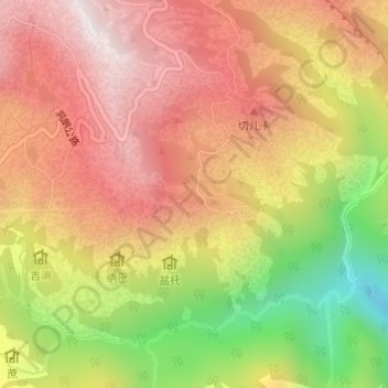
Name: Doklam Plateau topographic map, elevation, terrain.
Location: Doklam Plateau, Bhutan (27.29481 88.93464 27.29491 88.93474)
Average elevation: 3,946 m
Minimum elevation: 3,420 m
Maximum elevation: 4,318 m
Make a donation
Gear up for your next adventure:
As an Amazon Associate, this site earns from qualifying purchases at no extra cost to you.
Other topographic maps
Click on a map to view its topography, its elevation and its terrain.
Make a donation
Gear up for your next adventure:
As an Amazon Associate, this site earns from qualifying purchases at no extra cost to you.
Make a donation
Gear up for your next adventure:
As an Amazon Associate, this site earns from qualifying purchases at no extra cost to you.
Tala Hydroelectric Power Plant Bhutan
Bhutan > Chukha > Bjagchhog Gewog > Bjagchhog
Average elevation: 1,771 m
Make a donation
Gear up for your next adventure:
As an Amazon Associate, this site earns from qualifying purchases at no extra cost to you.
Make a donation
Gear up for your next adventure:
As an Amazon Associate, this site earns from qualifying purchases at no extra cost to you.
Make a donation
Gear up for your next adventure:
As an Amazon Associate, this site earns from qualifying purchases at no extra cost to you.
Make a donation
Gear up for your next adventure:
As an Amazon Associate, this site earns from qualifying purchases at no extra cost to you.
Thimphu
The city extends in a north–south direction on the west bank of the valley formed by the Wang Chhu, which flows out into India as the Raidāk River. Thimphu is the fifth highest capital in the world by altitude and the highest capital in Asia, ranging from 2,248 metres (7,375 feet) to 2,648 metres (8,688…
Average elevation: 3,005 m
Make a donation
Gear up for your next adventure:
As an Amazon Associate, this site earns from qualifying purchases at no extra cost to you.
Jigme Dorji National Park
Bhutan > Gasa District > Raminang_Uesana Chiwogs
The Jigme Dorji National Park (JDNP), named after the late Jigme Dorji Wangchuck, is the second-largest National Park of Bhutan. It occupies almost the entire Gasa District, as well as the northern areas of Thimphu District, Paro District, Punakha, and Wangdue Phodrang Districts. It was established in 1974 and…
Average elevation: 4,173 m
Make a donation
Gear up for your next adventure:
As an Amazon Associate, this site earns from qualifying purchases at no extra cost to you.
Make a donation
Gear up for your next adventure:
As an Amazon Associate, this site earns from qualifying purchases at no extra cost to you.
Make a donation
Gear up for your next adventure:
As an Amazon Associate, this site earns from qualifying purchases at no extra cost to you.
Make a donation
Gear up for your next adventure:
As an Amazon Associate, this site earns from qualifying purchases at no extra cost to you.
Dorithasa_Kowkha_Yangtse
Bhutan > Haa District > Gakiling Gewog > Dorithasa_Kowkha_Yangtse
Average elevation: 1,731 m
Make a donation
Gear up for your next adventure:
As an Amazon Associate, this site earns from qualifying purchases at no extra cost to you.
Chhusemu Chu
Bhutan > Wangdue Phodrang District > Saephu Gewog > Booso Zeri
Average elevation: 3,129 m
Wet Land
Bhutan > Trongsa District > Nubi Gewog > Bagochen Boolingpang Ueling
Average elevation: 2,195 m