
Make a donation
Gear up for your next adventure:
As an Amazon Associate, this site earns from qualifying purchases at no extra cost to you.
Shajapur topographic map
Click on the map to display elevation.
Make a donation
Gear up for your next adventure:
As an Amazon Associate, this site earns from qualifying purchases at no extra cost to you.
Shajapur
The region stretches from north to south in the middle of the district covering considerable portions of Agar Malwa and Shajapur tehsils and a small part of Susner tehsil. It is a part of the Malwa plateau with typical topography. There is a continuous chain of hills throughout the entire region. The height of the region varies between 450 and 530 meters above the mean sea level. The surface height decreases towards the north. Since it is an upland area, a number of seasonal streams originate from this zone and drain mostly towards the east. Lakundar and Ahu are the main streams flowing from south to north in this region. The streams that join the Lakundar river on its left bank, originate from this hill tract. The Ahu river drains along the western border of the region. The hilly terrain is covered with forest.
Make a donation
Gear up for your next adventure:
As an Amazon Associate, this site earns from qualifying purchases at no extra cost to you.
About this map
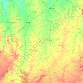
Name: Shajapur topographic map, elevation, terrain.
Location: Shajapur, Madhya Pradesh, India (23.10709 76.12015 23.63705 77.05107)
Average elevation: 466 m
Minimum elevation: 388 m
Maximum elevation: 610 m
Make a donation
Gear up for your next adventure:
As an Amazon Associate, this site earns from qualifying purchases at no extra cost to you.
Other topographic maps
Click on a map to view its topography, its elevation and its terrain.
Make a donation
Gear up for your next adventure:
As an Amazon Associate, this site earns from qualifying purchases at no extra cost to you.
Make a donation
Gear up for your next adventure:
As an Amazon Associate, this site earns from qualifying purchases at no extra cost to you.
Make a donation
Gear up for your next adventure:
As an Amazon Associate, this site earns from qualifying purchases at no extra cost to you.
Sehore
India > Madhya Pradesh > Sehore Nagar Tahsil
Sehore is 37 km from the state capital, Bhopal, towards the south-west and on the Bhopal - Indore highway. Its height from mean sea level is between 1500 ft. and 2000 ft. Sehore is situated on the Western Railway line from Bhopal to Ratlam. It is surrounded by 7 districts: Bhopal, Raisen, Harda, Hoshangabad,…
Average elevation: 501 m
Chanderi
India > Madhya Pradesh > Chanderi Tahsil
Chanderi is located at 24°43′N 78°08′E / 24.72°N 78.13°E / 24.72; 78.13. It has an average elevation of 456 metres (1496 feet).
Average elevation: 440 m
Make a donation
Gear up for your next adventure:
As an Amazon Associate, this site earns from qualifying purchases at no extra cost to you.
Make a donation
Gear up for your next adventure:
As an Amazon Associate, this site earns from qualifying purchases at no extra cost to you.
Make a donation
Gear up for your next adventure:
As an Amazon Associate, this site earns from qualifying purchases at no extra cost to you.
Make a donation
Gear up for your next adventure:
As an Amazon Associate, this site earns from qualifying purchases at no extra cost to you.
Make a donation
Gear up for your next adventure:
As an Amazon Associate, this site earns from qualifying purchases at no extra cost to you.
Jhabua
India > Madhya Pradesh > Jhabua Tahsil
Jhabua has an average elevation of 318 metres (1043 feet). Jhabua is located at the bottom left side of MP, mainly towards Gujarat.
Average elevation: 337 m
Make a donation
Gear up for your next adventure:
As an Amazon Associate, this site earns from qualifying purchases at no extra cost to you.
Make a donation
Gear up for your next adventure:
As an Amazon Associate, this site earns from qualifying purchases at no extra cost to you.
Narmada Udgam Kund
India > Madhya Pradesh > Pushparajgarh Tehsil > Amarkantak
Average elevation: 1,043 m
Make a donation
Gear up for your next adventure:
As an Amazon Associate, this site earns from qualifying purchases at no extra cost to you.
Make a donation
Gear up for your next adventure:
As an Amazon Associate, this site earns from qualifying purchases at no extra cost to you.
Make a donation
Gear up for your next adventure:
As an Amazon Associate, this site earns from qualifying purchases at no extra cost to you.
Make a donation
Gear up for your next adventure:
As an Amazon Associate, this site earns from qualifying purchases at no extra cost to you.
Make a donation
Gear up for your next adventure:
As an Amazon Associate, this site earns from qualifying purchases at no extra cost to you.
Make a donation
Gear up for your next adventure:
As an Amazon Associate, this site earns from qualifying purchases at no extra cost to you.
Make a donation
Gear up for your next adventure:
As an Amazon Associate, this site earns from qualifying purchases at no extra cost to you.
Lahar
India > Madhya Pradesh > Lahar Tahsil
Lahar is located at 26°07′N 78°34′E / 26.11°N 78.56°E / 26.11; 78.56. It has an average elevation of 275 metres (902 feet). Sports facilities in Lahar including a cricket stadium named after Indira Gandhi.
Average elevation: 155 m
Make a donation
Gear up for your next adventure:
As an Amazon Associate, this site earns from qualifying purchases at no extra cost to you.
Make a donation
Gear up for your next adventure:
As an Amazon Associate, this site earns from qualifying purchases at no extra cost to you.
Make a donation
Gear up for your next adventure:
As an Amazon Associate, this site earns from qualifying purchases at no extra cost to you.
Pachmarhi
India > Madhya Pradesh > Pipariya Tahsil
Pachmarhi has an altitude of 1067. Dhupgarh, the highest point (1,352 meters) in Madhya Pradesh and the Satpura range, is located nearby. The town is wholly located within the Pachmarhi Biosphere Reserve and the Satpura Tiger Reserve.
Average elevation: 968 m
Make a donation
Gear up for your next adventure:
As an Amazon Associate, this site earns from qualifying purchases at no extra cost to you.
Make a donation
Gear up for your next adventure:
As an Amazon Associate, this site earns from qualifying purchases at no extra cost to you.
Make a donation
Gear up for your next adventure:
As an Amazon Associate, this site earns from qualifying purchases at no extra cost to you.
Make a donation
Gear up for your next adventure:
As an Amazon Associate, this site earns from qualifying purchases at no extra cost to you.
Make a donation
Gear up for your next adventure:
As an Amazon Associate, this site earns from qualifying purchases at no extra cost to you.