
Chatham Island topographic map
Interactive map
Click on the map to display elevation.
About this map
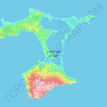
Name: Chatham Island topographic map, elevation, terrain.
Location: Chatham Island, Chatham Islands, 8942, Neuseeland (-44.13206 -176.89368 -43.69269 -176.19231)
Average elevation: 18 m
Minimum elevation: -1 m
Maximum elevation: 294 m
Die T-förmige, 899 km² große Insel ist geprägt von zwei großen Buchten, der Petre Bay im Westen mit dem Hauptort Waitangi und der über 35 km langen Hanson Bay im Osten. Dazwischen befindet sich die 179 km² große Te Whanga-Lagune, die nur durch Landbrücken von der See getrennt ist. Der Süden der Insel wird von einem Hochplateau eingenommen und erreicht im Maungatere Hill eine Höhe von 294 m über dem Meer. Weiterhin gibt es Torflandschaften und lange Sandstrände. Auf einer in die Lagune ragenden Halbinsel befindet sich der Flughafen Tuuta (IATA: CHT, ICAO: NZCI).
Other topographic maps
Click on a map to view its topography, its elevation and its terrain.
Castlepoint
Neuseeland > Wellington > Masterton District
Castlepoint, Masterton District, Wellington, Neuseeland
Average elevation: 29 m
Ashburton District
Ashburton District, Canterbury, Neuseeland
Average elevation: 661 m
Kaimanawa / Three Kings
Neuseeland > Manawatū-Whanganui > Ruapehu District
Kaimanawa / Three Kings, Ruapehu District, Manawatū-Whanganui, Neuseeland
Average elevation: 1,259 m
Arthur's Pass
Neuseeland > Canterbury > Selwyn District
Arthur's Pass, Selwyn District, Canterbury, 7875, Neuseeland
Average elevation: 1,204 m
Milford Sound / Piopiotahi
Neuseeland > Southland > Southland District > Fiordland Community
Milford Sound / Piopiotahi, Fiordland Community, Southland District, Southland, Neuseeland
Average elevation: 655 m
Aua / King Billy Island
Neuseeland > Canterbury > Christchurch City > Banks Peninsula Community
Aua / King Billy Island, Diamond Harbour, Banks Peninsula Community, Christchurch City, Canterbury, Neuseeland
Average elevation: 6 m
Baal
Neuseeland > West Coast > Westland District
Baal, Westland District, West Coast, Neuseeland
Average elevation: 522 m
Twizel
Neuseeland > Canterbury > Mackenzie District
Twizel, Mackenzie District, Canterbury, 7901, Neuseeland
Average elevation: 472 m
Te Puke
Neuseeland > Bay of Plenty > Western Bay of Plenty District
Te Puke, Western Bay of Plenty District, Bay of Plenty, 3182, Neuseeland
Average elevation: 36 m
Oamaru
Neuseeland > Otago > Waitaki District
Oamaru, Waitaki District, Otago, 9444, Neuseeland
Average elevation: 34 m
Huriwa Historic Reserve
Neuseeland > Otago > Dunedin City > Karitane
Huriwa Historic Reserve, Kilda Street, Karitane, Dunedin City, Otago, 9510, Neuseeland
Average elevation: 2 m
Reefton
Neuseeland > West Coast > Buller District
Reefton, Buller District, West Coast, 7830, Neuseeland
Average elevation: 310 m
Halswell-Hornby-Riccarton Community
Neuseeland > Canterbury > Christchurch City
Halswell-Hornby-Riccarton Community, Christchurch City, Canterbury, Neuseeland
Average elevation: 49 m
Hurunui District
Neuseeland > Canterbury > Hurunui District
Hurunui District, Canterbury, Neuseeland
Average elevation: 674 m
Lake Te Au
Neuseeland > Southland > Southland District > Fiordland Community
Lake Te Au, Fiordland Community, Southland District, Southland, Neuseeland
Average elevation: 597 m
Hibiscus Coast
Neuseeland > Auckland > Hibiscus Coast
Hibiscus Coast, Hibiscus and Bays, Auckland, 0932, Neuseeland
Average elevation: 40 m
Tairua
Neuseeland > Waikato > Thames-Coromandel District
Tairua, Thames-Coromandel District, Waikato, 3579, Neuseeland
Average elevation: 222 m
Castle Rock
Neuseeland > Waikato > Thames-Coromandel District
Castle Rock, Thames-Coromandel District, Waikato, Neuseeland
Average elevation: 217 m
Matira / Castle Rock
Neuseeland > Wellington > Masterton District > Castlepoint
Matira / Castle Rock, Castlepoint, Masterton District, Wellington, Neuseeland
Average elevation: 25 m
Christchurch
Neuseeland > Canterbury > Christchurch City
Christchurch, Christchurch City, Canterbury, Neuseeland
Average elevation: 41 m
Hampden
Neuseeland > Otago > Waitaki District > Hampden
Hampden, Waitaki District, Otago, 9410, Neuseeland
Average elevation: 23 m
Omaha Beach
Neuseeland > Auckland > Rodney > Omaha
Omaha Beach, Omaha, Rodney, Auckland, Neuseeland
Average elevation: 3 m
Maungakiekie-Tāmaki
Maungakiekie-Tāmaki, Auckland, Neuseeland
Average elevation: 23 m
745
Neuseeland > Wellington > South Wairarapa District > Greytown Community
745, Greytown Community, South Wairarapa District, Wellington, Neuseeland
Average elevation: 520 m
Runciman
Neuseeland > Auckland > Franklin > Runciman
Runciman, Franklin, Auckland, 2578, Neuseeland
Average elevation: 20 m
Lauder
Neuseeland > Vincent Community > Lauder
Lauder, Vincent Community, Central Otago District, Otago, Neuseeland
Average elevation: 358 m
Lake Taupo
Lake Taupo, Taupō District, Waikato, Neuseeland
Average elevation: 416 m
Hahei Beach
Neuseeland > Waikato > Thames Coromandel District > Hahei
Hahei Beach, Hahei, Thames Coromandel District, Waikato, Neuseeland
Average elevation: 29 m
Whangarei District
Neuseeland > Whangarei District
Whangarei District, Northland, Neuseeland
Average elevation: 98 m
Te Anau
Neuseeland > Southland > Southland District > Fiordland Community
Te Anau, Fiordland Community, Southland District, Southland, 9600, Neuseeland
Average elevation: 249 m
Maruia Springs
Maruia Springs, Buller District, West Coast, Neuseeland
Average elevation: 1,022 m
Punakaiki
Punakaiki, Buller District, West Coast, 7873, Neuseeland
Average elevation: 70 m
Wellington
Neuseeland > Wellington > Wellington City
Wellington, Wellington City, Wellington, 6011, Neuseeland
Average elevation: 85 m
Kaikōura District
Kaikōura District, Canterbury, Neuseeland
Average elevation: 621 m
Havelock North
Havelock North, Hastings District, Hawke's Bay, 4130, Neuseeland
Average elevation: 45 m
Invercargill City
Neuseeland > Invercargill City
Invercargill City, Southland, Neuseeland
Average elevation: 11 m
Wellington City
Wellington City, Wellington, Neuseeland
Average elevation: 80 m