
Lake County topographic map
Interactive map
Click on the map to display elevation.
Lake County
The central part of the county is higher and hillier. As you travel south from the low and relatively flat lake plain in the northern part of the county, the land gradually rises in elevation until the peak of the Valparaiso Moraine. The highest point, at 801 feet (244 m), is in northeastern Winfield Township near 109th Street and North Lakeshore Drive in Lakes of the Four Seasons. From here the land descends south into the Kankakee Outwash Plain until the Kankakee River is reached.
About this map
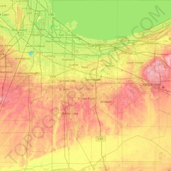
Name: Lake County topographic map, elevation, terrain.
Location: Lake County, Indiana, United States (41.16195 -87.52671 41.76089 -87.21884)
Average elevation: 202 m
Minimum elevation: 144 m
Maximum elevation: 267 m
Other topographic maps
Click on a map to view its topography, its elevation and its terrain.
Indianapolis
United States > Indiana > Indianapolis
Indianapolis is within the Tipton Till Plain, a flat to gently sloping terrain underlain by glacial deposits known as till. The lowest point in the city is about 650 feet (198 m) above mean sea level, with the highest natural elevation at about 900 feet (274 m) above sea level. Few hills or short ridges, known…
Average elevation: 241 m
Johnson Lake
United States > Indiana > Jefferson County > Madison > North Madison
Average elevation: 266 m
Fort Benjamin Harrison State Park and Nature Preserve
United States > Indiana > Marion County > Indianapolis
Average elevation: 254 m
Indiana Dunes State Park
United States > Indiana > Porter County > Chesterton
Average elevation: 186 m
Country Club Meadows
United States > Indiana > Vanderburgh County > Evansville
Average elevation: 126 m