
Louisiana topographic map
Interactive map
Click on the map to display elevation.
About this map
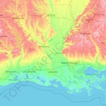
Name: Louisiana topographic map, elevation, terrain.
Location: Louisiana, United States (28.85429 -94.04319 33.01959 -88.75833)
Average elevation: 39 m
Minimum elevation: -4 m
Maximum elevation: 196 m
The higher and contiguous hill lands of the north and northwestern part of the state have an area of more than 25,000 square miles (65,000 km2). They consist of prairie and woodlands. The elevations above sea level range from 10 feet (3 m) at the coast and swamp lands to 50–60 feet (15–18 m) at the prairie and alluvial lands. In the uplands and hills, the elevations rise to Driskill Mountain, the highest point in the state only 535 feet (163 m) above sea level. From 1932 to 2010 the state lost 1,800 square miles due to rises in sea level and erosion. The Louisiana Coastal Protection and Restoration Authority (CPRA) spends around $1 billion per year to help shore up and protect Louisiana shoreline and land in both federal and state funding.
Other topographic maps
Click on a map to view its topography, its elevation and its terrain.
Santa Barbara
United States > California > Santa Barbara County
Santa Barbara, Santa Barbara County, California, United States
Average elevation: 119 m
Santa Cruz
United States > California > Santa Cruz County
Santa Cruz, Santa Cruz County, California, United States
Average elevation: 89 m
Brooklyn
United States > New York > New York
Brooklyn, Kings County, New York, United States
Average elevation: 9 m
Aurora
United States > Colorado > Adams County
Aurora, Adams County, Colorado, United States
Average elevation: 1,691 m
Albuquerque
United States > New Mexico > Bernalillo County
Albuquerque, Bernalillo County, New Mexico, United States
Average elevation: 1,688 m
Houston
United States > Texas > Harris County
Houston, Harris County, Texas, United States
Average elevation: 25 m
Manhattan
United States > New York > New York County > New York
Manhattan, New York County, New York, United States
Average elevation: 16 m
Hillsborough County
Hillsborough County, Florida, United States
Average elevation: 20 m
Allegheny County
Allegheny County, Pennsylvania, United States
Average elevation: 325 m
Parker
United States > Colorado > Douglas County
Parker, Douglas County, Colorado, 80134, United States
Average elevation: 1,845 m
Jacksonville
United States > Florida > Duval County
Jacksonville, Duval County, Florida, United States
Average elevation: 10 m
Cape Cod
United States > Massachusetts > Plymouth County
Cape Cod, Plymouth County, Massachusetts, United States
Average elevation: 2 m
Indianapolis
United States > Indiana > Indianapolis
Indianapolis, Marion County, Indiana, 46204, United States
Average elevation: 241 m
Tampa
United States > Florida > Hillsborough County
Tampa, Hillsborough County, Florida, United States
Average elevation: 11 m
Knoxville
United States > Tennessee > Knox County
Knoxville, Knox County, East Tennessee, Tennessee, United States
Average elevation: 307 m
Hudson River
Hudson River, New Jersey, 12834:12871, United States
Average elevation: 297 m
Central Park
United States > New York > New York County > New York
Central Park, New York County, New York, United States
Average elevation: 26 m
Oakland County
Oakland County, Michigan, United States
Average elevation: 282 m