
Make a donation
Gear up for your next adventure:
As an Amazon Associate, this site earns from qualifying purchases at no extra cost to you.
Michigan topographic map
Click on the map to display elevation.
Make a donation
Gear up for your next adventure:
As an Amazon Associate, this site earns from qualifying purchases at no extra cost to you.
Michigan
Michigan's topography is characterized by a diverse landscape that transitions from flat plains to rugged hills. The state comprises two peninsulas, with the Upper Peninsula showcasing more pronounced elevation changes, including its highest point, Mount Arvon, which rises to 1,979 feet (603 meters). In contrast, the Lower Peninsula features relatively flat terrain with some rolling hills, particularly in its southern regions. The average elevation across Michigan is around 862 feet (263 meters), and notable features include the Great Lakes, which greatly influence the state’s ecology and climate. Additionally, the landscape is marked by various lakes, rivers, and even significant sand dunes along the Lake Michigan shoreline, some reaching heights over 200 feet (61 meters). This unique blend of geographic features contributes to Michigan's rich natural beauty and ecological diversity.
Make a donation
Gear up for your next adventure:
As an Amazon Associate, this site earns from qualifying purchases at no extra cost to you.
About this map
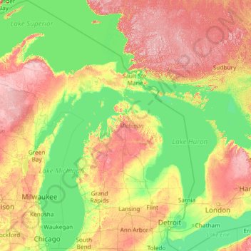
Name: Michigan topographic map, elevation, terrain.
Location: Michigan, United States (41.69613 -90.41862 48.30606 -82.12281)
Average elevation: 259 m
Minimum elevation: 169 m
Maximum elevation: 653 m
Make a donation
Gear up for your next adventure:
As an Amazon Associate, this site earns from qualifying purchases at no extra cost to you.
Other topographic maps
Click on a map to view its topography, its elevation and its terrain.
San Francisco Bay Area
United States > California > San Francisco
The San Francisco Bay Area is characterized by a diverse and dynamic topography shaped by geological processes over millions of years. This region features a combination of coastal plains, steep hills, and rugged mountains, all influenced by the tectonic activity associated with the nearby San Andreas Fault…
Average elevation: 113 m
Appalachian Mountains
United States > North Carolina > Yancey County
The Appalachian Mountains (French: Appalaches), often called the Appalachians, are a system of mountains in eastern to northeastern North America. The Appalachians first formed roughly 480 million years ago during the Ordovician Period. They once reached elevations similar to those of the Alps and the Rocky…
Average elevation: 1,463 m
Baltimore
United States > Maryland > Baltimore
Baltimore is in north-central Maryland on the Patapsco River close to where it empties into the Chesapeake Bay. The city is also located on the fall line between the Piedmont Plateau and the Atlantic coastal plain, which divides Baltimore into "lower city" and "upper city". The city's elevation ranges from sea…
Average elevation: 65 m
Make a donation
Gear up for your next adventure:
As an Amazon Associate, this site earns from qualifying purchases at no extra cost to you.
Anna Maria island
United States > Florida > Manatee County
Anna Maria Island features a flat, sandy topography typical of a barrier island on the Gulf Coast. With an average elevation of around 15 feet above sea level, the terrain includes broad beaches, low dunes, and narrow stretches of sandy soil, making it highly vulnerable to storm surges and tidal flooding. The…
Average elevation: 2 m
Make a donation
Gear up for your next adventure:
As an Amazon Associate, this site earns from qualifying purchases at no extra cost to you.
Strawberry Mansion
United States > Pennsylvania > Philadelphia County > Philadelphia
Average elevation: 31 m
Make a donation
Gear up for your next adventure:
As an Amazon Associate, this site earns from qualifying purchases at no extra cost to you.
Navarre
United States > Florida > Santa Rosa County
Navarre is located at 30°24′04″N 86°51′47″W / 30.401°N 86.863°W / 30.401; -86.863Coordinates: 30°24′04″N 86°51′47″W / 30.401°N 86.863°W / 30.401; -86.863. It is located within a portion of the Florida Panhandle observing the Central Time Zone. Elevation is at an average of 10 feet (3.0 m).
Average elevation: 4 m
Virginia Beach
United States > Virginia > Virginia Beach
According to the United States Census Bureau, the city has a total area of 497 square miles (1,290 km2), of which 249 square miles (640 km2) is land and 248 square miles (640 km2) (49.9%) is water. It is the largest city in Virginia by total area and third-largest city land area. The average elevation is 12…
Average elevation: 2 m
El Dorado Hills
United States > California > El Dorado County > Cameron Park
El Dorado Hills (EDH), as defined by the 2010 census-designated place (CDP), is at the western border of El Dorado County, between the City of Folsom and the unincorporated community of Cameron Park. The northern limits of the CDP are Folsom Lake and the South Fork of the American River, where river rafters…
Average elevation: 254 m
Make a donation
Gear up for your next adventure:
As an Amazon Associate, this site earns from qualifying purchases at no extra cost to you.
Columbus
United States > Ohio > Franklin County > Columbus
The confluence of the Scioto and Olentangy rivers is just north-west of Downtown Columbus. Several smaller tributaries course through the Columbus metropolitan area, including Alum Creek, Big Walnut Creek, and Darby Creek. Columbus is considered to have relatively flat topography thanks to a large glacier that…
Average elevation: 255 m
Port Charlotte
United States > Florida > Charlotte County
Port Charlotte is characterized by a predominantly flat and low-lying terrain, typical of Florida’s coastal landscape. The area features a network of waterways, including the Peace River and Charlotte Harbor, which provide ample opportunities for recreational activities like boating and fishing. Elevations…
Average elevation: 4 m
Ponte Vedra Beach
United States > Florida > Saint Johns County > Ponte Vedra Beach
Ponte Vedra Beach is characterized by its gently rolling terrain that is primarily flat and lies only about 15 feet above sea level. The landscape is predominantly shaped by coastal dunes and the proximity to the Atlantic Ocean, resulting in sandy beaches interspersed with vegetation typical of barrier island…
Average elevation: 3 m
Little Saint James Island
United States > United States Virgin Islands > Saint Thomas - Saint John District
Average elevation: 1 m
Make a donation
Gear up for your next adventure:
As an Amazon Associate, this site earns from qualifying purchases at no extra cost to you.
Albuquerque
United States > New Mexico > Bernalillo County
Albuquerque is located in north-central New Mexico. To its east are the Sandia–Manzano Mountains. The Rio Grande flows north to south through its center, while the West Mesa and Petroglyph National Monument make up the western part of the city. Albuquerque has one of the highest elevations of any major city…
Average elevation: 1,671 m
Georgetown
United States > Texas > Georgetown
The city is located on the northeastern edge of Texas Hill Country. Portions of Georgetown are located on either side of the Balcones Escarpment, a fault line in which the areas roughly east of IH-35 are flat and characterized by having black, fertile soils of the Blackland Prairie, and the west side of the…
Average elevation: 219 m
Make a donation
Gear up for your next adventure:
As an Amazon Associate, this site earns from qualifying purchases at no extra cost to you.
Stone Mountain
United States > Georgia > DeKalb County
The park is owned by the state of Georgia and is currently managed by Herschend Family Entertainment. At its summit, the elevation is 1,686 feet (514 m) above sea level and 825 feet (251 m) above the surrounding area. Stone Mountain is well known for not only its geology, but also the enormous rock relief on…
Average elevation: 299 m
Make a donation
Gear up for your next adventure:
As an Amazon Associate, this site earns from qualifying purchases at no extra cost to you.
South Salem
United States > New York > Westchester County > Town of Lewisboro
Average elevation: 174 m
Ridge Manor
United States > Florida > Hernando County > Brooksville > Ridge Manor
Average elevation: 22 m
Make a donation
Gear up for your next adventure:
As an Amazon Associate, this site earns from qualifying purchases at no extra cost to you.
Crowley Lake
United States > California > Mono County
Crowley Lake is a census-designated place in Mono County, California. Crowley Lake sits at an elevation of 6,939 feet (2,115 m). The 2020 United States census reported Crowley Lake's population was 980.
Average elevation: 2,251 m
Make a donation
Gear up for your next adventure:
As an Amazon Associate, this site earns from qualifying purchases at no extra cost to you.
Samsula-Spruce Creek
United States > Florida > Volusia County > New Smyrna Beach > South Village
Average elevation: 8 m
Hobcaw Point
United States > South Carolina > Charleston County > Mount Pleasant
Average elevation: 4 m
Make a donation
Gear up for your next adventure:
As an Amazon Associate, this site earns from qualifying purchases at no extra cost to you.
Ricketts Glen State Park
United States > Pennsylvania > Luzerne County > Fairmount Township
The state's original plans for the new park included building an inn, an 18-hole golf course and country club, and a winter sports complex for skiing, ice boating, and tobogganing, as well as a beach with bathing facilities, cabins, and a tent camping area. Only the last three were actually built, all south of…
Average elevation: 588 m
Appalachian Mountains
United States > North Carolina > Yancey County
The Appalachian Mountains (French: Appalaches), often called the Appalachians, are a system of mountains in eastern to northeastern North America. The Appalachians first formed roughly 480 million years ago during the Ordovician Period. They once reached elevations similar to those of the Alps and the Rocky…
Average elevation: 1,463 m
Make a donation
Gear up for your next adventure:
As an Amazon Associate, this site earns from qualifying purchases at no extra cost to you.
Lutz
United States > Florida > Hillsborough County > Tampa
Lutz is characterized by a gently rolling topography that showcases the distinctive features of the central Florida landscape. The area has an average elevation of about 70 feet (21 meters) above sea level, contributing to its mild undulations rather than dramatic elevation changes. The terrain is marked by a…
Average elevation: 20 m
Central Park
United States > New York > New York County > New York
In June 1856, Fernando Wood appointed a "consulting board" of seven people, headed by author Washington Irving, to inspire public confidence in the proposed development. Wood hired military engineer Egbert Ludovicus Viele as the park's chief engineer, tasking him with a topographical survey of the site. The…
Average elevation: 26 m
Make a donation
Gear up for your next adventure:
As an Amazon Associate, this site earns from qualifying purchases at no extra cost to you.
Johnston Island
The climate is tropical but generally dry. Northeast trade winds are consistent and there is little seasonal temperature variation. With elevation ranging from sea level to 5 m (16 ft) at Summit Peak, the islands contain some low-growing vegetation and palm trees on mostly flat terrain, and no natural fresh…
Average elevation: 1 m
Rescue
United States > California > El Dorado County > Cameron Park
Rescue, formerly Green Valley, El Dorado County, California, is an unincorporated community in El Dorado County, California. It is located north-northwest of Shingle Springs and north-northeast of Cameron Park. The zip code is 95672, and Rescue is located in area code 530. The town lies at an elevation of 1214…
Average elevation: 393 m
Make a donation
Gear up for your next adventure:
As an Amazon Associate, this site earns from qualifying purchases at no extra cost to you.
Hoover Dam
United States > Arizona > Mohave County
The amount of electricity generated by Hoover Dam has been decreasing along with the falling water level in Lake Mead due to the prolonged drought since year 2000 and high demand for the Colorado River's water. By 2014 its generating capacity was downrated by 23% to 1592 MW and was providing power only during…
Average elevation: 429 m
Make a donation
Gear up for your next adventure:
As an Amazon Associate, this site earns from qualifying purchases at no extra cost to you.
Make a donation
Gear up for your next adventure:
As an Amazon Associate, this site earns from qualifying purchases at no extra cost to you.
Lebec
United States > California > Kern County
According to the United States Census Bureau, Lebec has an area of 15.3 square miles (40 km2). The community, which is near Tejon Pass, lies at an elevation of 3,481 feet (1,061 m).
Average elevation: 1,162 m
Make a donation
Gear up for your next adventure:
As an Amazon Associate, this site earns from qualifying purchases at no extra cost to you.
Santa Cruz Mountains
United States > California > Santa Clara County
The Santa Cruz Mountains are a region of great biological diversity, encompassing cool, moist coastal ecosystems as well as warm, dry chaparral. Much of the area in the Santa Cruz mountains is considered temperate rainforest. In valleys and moist ocean-facing slopes some of the southernmost coast redwoods…
Average elevation: 230 m
Make a donation
Gear up for your next adventure:
As an Amazon Associate, this site earns from qualifying purchases at no extra cost to you.
Palmyra Atoll
In 1962, the Department of Defense used Palmyra as an observation site during several high-altitude nuclear weapons tests high above Johnston Atoll. A group of about ten men supported the observation posts during this series of tests, while about 40 people carried out the observations.
Average elevation: 0 m
Keystone Lake
United States > Oklahoma > Osage County > Westport
The spillway is a gated ogee weir, 720 feet (220 m) wide with eighteen tainter gates, each 40 by 35 feet (12 by 11 m). Spillway capacity at the maximum pool level (elevation 766.0 feet (233.5 m)) is 939,000 cubic feet per second (26,600 m3/s). Capacity at the top of the flood control pool level (elevation…
Average elevation: 241 m
Rocky Mountains
United States > Wyoming > Teton County
Agriculture and forestry are major industries. Agriculture includes dryland and irrigated farming and livestock grazing. Livestock are frequently moved between high-elevation summer pastures and low-elevation winter pastures, a practice known as transhumance.
Average elevation: 2,292 m
Make a donation
Gear up for your next adventure:
As an Amazon Associate, this site earns from qualifying purchases at no extra cost to you.
Parrish
United States > Florida > Manatee County
Parrish features a predominantly flat terrain with an average elevation of approximately 36 feet above sea level. The area's landscape is characterized by gently rolling hills and low-lying regions, making it typical of the Central Florida topography. Surrounding Parrish are numerous wetlands and drainage…
Average elevation: 12 m
Evergreen
United States > Colorado > Jefferson County
Evergreen sits at an elevation of 7,220 feet (2,200 m) in the Rocky Mountains, 19 miles west of Denver, Colorado. Its addresses are oriented according to the Street_system_of_Denver.
Average elevation: 2,309 m
Grand Lake
United States > Colorado > Grand County
Established in 1881, Grand Lake sits at an elevation of 8,369 feet (2,551 m) and derives its name from the lake on whose shores it is situated: Grand Lake, the largest natural body of water in Colorado. The town of Grand Lake was originally an outfitting and supply point for the mining settlements of Lulu…
Average elevation: 2,630 m
Make a donation
Gear up for your next adventure:
As an Amazon Associate, this site earns from qualifying purchases at no extra cost to you.
Atigun Pass
United States > Alaska > North Slope Borough
Atigun Pass (/ˈætɪɡən/ AT-i-gən), elevation 4,739 feet (1,444 m), is a high mountain pass across the Brooks Range in Alaska, located at the head of the Dietrich River. It is where the Dalton Highway crosses the Continental Divide (at mile marker 244), and is the highest pass in Alaska that is maintained…
Average elevation: 1,530 m
Make a donation
Gear up for your next adventure:
As an Amazon Associate, this site earns from qualifying purchases at no extra cost to you.
Tyler State Park
United States > Pennsylvania > Bucks County > Northampton Township
Average elevation: 67 m
Make a donation
Gear up for your next adventure:
As an Amazon Associate, this site earns from qualifying purchases at no extra cost to you.
Mount Magazine State Park
United States > Arkansas > Logan County
There also exist many opportunities for ATV riding, backpacking, hang gliding, mountain biking, rappelling, and rock climbing within the park. The park hosts the annual Mount Magazine International Butterfly Festival, and is a haven for many rare species of butterflies in Arkansas due to the special blend of…
Average elevation: 447 m
Saint Elmo
United States > Colorado > Chaffee County
Saint Elmo is a ghost town in Chaffee County, Colorado, United States. Founded in 1880, Saint Elmo lies in the heart of the Sawatch Range, 20 miles (32 km) southwest of Buena Vista and sits at an elevation of 9,961 feet (3,036 m). Nearly 2,000 people settled in this town when mining for gold and silver…
Average elevation: 3,247 m
Make a donation
Gear up for your next adventure:
As an Amazon Associate, this site earns from qualifying purchases at no extra cost to you.
Colorado River
United States > Colorado > Mesa County > Clifton
The entire eastern boundary of the Colorado River Basin runs along the North American Continental Divide and is defined largely by the Rocky Mountains and the Rio Grande Basin. The Wind River Range in Wyoming marks the northern extent of the basin, and is separated from the Colorado Rockies by the endorheic…
Average elevation: 1,417 m
Make a donation
Gear up for your next adventure:
As an Amazon Associate, this site earns from qualifying purchases at no extra cost to you.
Make a donation
Gear up for your next adventure:
As an Amazon Associate, this site earns from qualifying purchases at no extra cost to you.
Highlands
United States > California > San Mateo County > San Mateo Highlands
Average elevation: 129 m
Brackney
United States > Pennsylvania > Susquehanna County > Silver Lake Township
Average elevation: 491 m
Make a donation
Gear up for your next adventure:
As an Amazon Associate, this site earns from qualifying purchases at no extra cost to you.