
Butnan topographic map
Interactive map
Click on the map to display elevation.
Butnan
Libya has mostly a flat undulating plain and occasional plateau, with an average elevation of around 423 m (1,388 ft). Around 91 per cent of the land is covered by desert, with only 8.8 per cent agricultural land (with only 1% arable lands) and 0.1 per cent of forests. The major resources are petroleum, gypsum and natural gas. Along the coastal regions, the climate is Mediterranean in coastal areas, while it is desert climate in all other parts. Dust storms lasting four to eight days is pretty common during Spring. Triplotania is the northwest region, while it is Cyrenacia in the east and Fezzen in southwest. Cyrenacia is the largest region in Libya, which is mostly semi arid in nature. The region receives an annual rainfall of 5 in (130 mm). There are no perennial rivers in the region, but the region is abundant with groundwater aquifers.
About this map
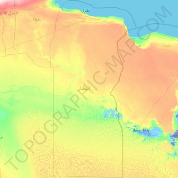
Name: Butnan topographic map, elevation, terrain.
Location: Butnan, Libya (28.09333 22.95560 32.38638 25.37706)
Average elevation: 111 m
Minimum elevation: -79 m
Maximum elevation: 580 m
Other topographic maps
Click on a map to view its topography, its elevation and its terrain.
Libyan Desert
Sand plains, dunes, ridges, and some depressions (basins) typify the endorheic region, with no rivers draining into or out of the desert. The Gilf Kebir plateau reaches an altitude of just over 1,000 m (3,300 feet), and along with the nearby massif of Jebel Uweinat is an exception to the uninterrupted…
Average elevation: 566 m
Tarhuna
During the late 1950s and into the 1960s, the RAF established a bombing range on the outskirts of the town. It was manned by RAF personnel from nearby RAF Idris and it was used by Canberra bombers from various bases in Germany. The range consisted of a main control tower with full equipment for communication…
Average elevation: 360 m
Benghazi
The largest Ottoman architectural monument in Benghazi is the late 19th-century Ottoman palace in El-Berka; built during the rule of Rashid Pasha II. The front elevation was completed in 1895, whilst the side sections were added later during Italian rule. The white and green structure houses 360 rooms; and is…
Average elevation: 23 m
Bayda
The city of Bayda has a mild Mediterranean climate (Csb, according to the Köppen climate classification) with an average annual precipitation of 540 millimetres or 21 inches. It is famous for recurring snow falls and heavy rains, where the temperature rises in the summer time to 30 °C (86 °F), but in the…
Average elevation: 504 m