
Black Mountain topographic map
Interactive map
Click on the map to display elevation.
About this map
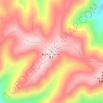
Name: Black Mountain topographic map, elevation, terrain.
Location: Black Mountain, Harlan County, Kentucky, United States (36.91428 -82.89391 36.91438 -82.89381)
Average elevation: 1,108 m
Minimum elevation: 810 m
Maximum elevation: 1,253 m
Black Mountain is the highest mountain peak in the Commonwealth of Kentucky, United States, with a summit elevation of 4,145 feet (1,263 m) above mean sea level and a top-to-bottom height of over 2,500 feet (760 m). The summit is located at approximately 36°54′51″N 82°53′38″W / 36.91417°N 82.89389°W / 36.91417; -82.89389 in Harlan County, Kentucky near the Virginia border, just above the towns of Lynch, Kentucky and Appalachia, Virginia. It is alternatively known as Katahrin's Mountain, and is about 500 feet (150 m) taller than any other mountain in Kentucky.
Other topographic maps
Click on a map to view its topography, its elevation and its terrain.
Lexington
United States > Kentucky > Lexington
Lexington, Fayette County, Kentucky, 40508, United States
Average elevation: 285 m
East Bernstadt
United States > Kentucky > Laurel County
East Bernstadt, Laurel County, Kentucky, United States
Average elevation: 367 m
Sandhill
United States > Kentucky > Muhlenberg County
Sandhill, Muhlenberg County, Kentucky, 42369, United States
Average elevation: 143 m
McDowell
United States > Kentucky > Floyd County
McDowell, Floyd County, Kentucky, 41647, United States
Average elevation: 324 m
Indian Hills Cherokee Section
United States > Kentucky > Jefferson County > Indian Hills
Indian Hills Cherokee Section, Indian Hills, Jefferson County, Kentucky, 40207, United States
Average elevation: 168 m
Morning View
United States > Kentucky > Kenton County
Morning View, Kenton County, Kentucky, 41063, United States
Average elevation: 192 m
Broad Bottom
United States > Kentucky > Pike County
Broad Bottom, Pike County, Kentucky, 41659, United States
Average elevation: 274 m
Louisville
United States > Kentucky > Jefferson County > Louisville
Louisville, Jefferson County, Kentucky, 40202-2923, United States
Average elevation: 180 m
Plumville
United States > Kentucky > Mason County
Plumville, Mason County, Kentucky, United States
Average elevation: 247 m
Lawrence County
Lawrence County, Kentucky, United States
Average elevation: 255 m
Carrollton
United States > Kentucky > Carroll County
Carrollton, Carroll County, Kentucky, United States
Average elevation: 170 m
Livingston County
Livingston County, Kentucky, United States
Average elevation: 131 m
Keaton
United States > Kentucky > Johnson County
Keaton, Johnson County, Kentucky, 41226, United States
Average elevation: 270 m
Owensboro
United States > Kentucky > Daviess County
Owensboro, Daviess County, Kentucky, United States
Average elevation: 123 m
Aboretum
United States > Kentucky > Calloway County > Murray
Aboretum, Murray, Calloway County, Kentucky, United States
Average elevation: 168 m
Edsel
United States > Kentucky > Elliott County
Edsel, Elliott County, Kentucky, United States
Average elevation: 277 m
Dunmor
United States > Kentucky > Muhlenberg County
Dunmor, Muhlenberg County, Kentucky, 42339, United States
Average elevation: 179 m
Villa Hills
United States > Kentucky > Kenton County
Villa Hills, Kenton County, Kentucky, United States
Average elevation: 224 m
Oak Grove
United States > Kentucky > Christian County
Oak Grove, Christian County, Kentucky, 42262, United States
Average elevation: 170 m
Muhlenberg County
Muhlenberg County, Kentucky, United States
Average elevation: 144 m
Burtonville
United States > Kentucky > Lewis County
Burtonville, Lewis County, Kentucky, United States
Average elevation: 254 m
Buster Hill
United States > Kentucky > Wayne County > Monticello
Buster Hill, Monticello, Wayne County, Kentucky, 42633, United States
Average elevation: 295 m
Limp
United States > Kentucky > Hardin County
Limp, Hardin County, Kentucky, United States
Average elevation: 211 m
Danville
United States > Kentucky > Boyle County
Danville, Boyle County, Kentucky, United States
Average elevation: 290 m
Elizabethtown
United States > Kentucky > Hardin County
Elizabethtown, Hardin County, Kentucky, 42701, United States
Average elevation: 241 m
Hindman
United States > Kentucky > Knott County
Hindman, Knott County, Kentucky, United States
Average elevation: 388 m
E.P. "Tom" Sawyer State Park
United States > Kentucky > Jefferson County > Louisville > Lakeland
E.P. "Tom" Sawyer State Park, Lakeland, Louisville, Jefferson County, Kentucky, United States
Average elevation: 209 m
Lebanon Junction
United States > Kentucky > Bullitt County
Lebanon Junction, Bullitt County, Kentucky, United States
Average elevation: 144 m
Gilbertsville
United States > Kentucky > Marshall County
Gilbertsville, Marshall County, Kentucky, United States
Average elevation: 104 m
Clark County
Clark County, Kentucky, 40391, United States
Average elevation: 273 m
Morehead
United States > Kentucky > Rowan County
Morehead, Rowan County, Kentucky, 40351, United States
Average elevation: 287 m
McConnell Springs
United States > Kentucky > Fayette County > Lexington
McConnell Springs, Lexington, Fayette County, Kentucky, United States
Average elevation: 287 m
Guthrie
United States > Kentucky > Todd County
Guthrie, Todd County, Kentucky, United States
Average elevation: 172 m
Maysville
United States > Kentucky > Mason County
Maysville, Mason County, Kentucky, 41056, United States
Average elevation: 236 m
Wilmore
United States > Kentucky > Jessamine County
Wilmore, Jessamine County, Kentucky, 40390, United States
Average elevation: 272 m
Dry Ridge
United States > Kentucky > Grant County
Dry Ridge, Grant County, Kentucky, United States
Average elevation: 274 m
Epperson
United States > Kentucky > McCracken County
Epperson, McCracken County, Kentucky, United States
Average elevation: 107 m
Hampton Manor
United States > Kentucky > Clark County > Winchester
Hampton Manor, Winchester, Clark County, Kentucky, 40391, United States
Average elevation: 297 m
Nicholasville
United States > Kentucky > Jessamine County
Nicholasville, Jessamine County, Kentucky, 40356, United States
Average elevation: 285 m
Eolia
United States > Kentucky > Letcher County
Eolia, Letcher County, Kentucky, 40826, United States
Average elevation: 612 m
William Whitley State Historic House
United States > Kentucky > Lincoln County
William Whitley State Historic House, Lincoln County, Kentucky, United States
Average elevation: 284 m
Crestwood
United States > Kentucky > Oldham County
Crestwood, Oldham County, Kentucky, United States
Average elevation: 223 m
West Point
United States > Kentucky > Hardin County
West Point, Hardin County, Kentucky, United States
Average elevation: 163 m
Taylor Mill
United States > Kentucky > Kenton County
Taylor Mill, Kenton County, Kentucky, 41015, United States
Average elevation: 211 m
Shakertown
United States > Kentucky > Mercer County
Shakertown, Mercer County, Kentucky, United States
Average elevation: 252 m