
Niagara Region topographic map
Click on the map to display elevation.
About this map
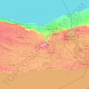
Name: Niagara Region topographic map, elevation, terrain.
Location: Niagara Region, Golden Horseshoe, Ontario, Canada (42.83200 -79.75396 43.26603 -78.90595)
Average elevation: 148 m
Minimum elevation: 72 m
Maximum elevation: 259 m
Other topographic maps
Click on a map to view its topography, its elevation and its terrain.
Christian Island
Canada > Ontario > Simcoe County
Christian Island is a large island in Georgian Bay close to the communities of Penetanguishene and Midland, Ontario. The island, with its neighbours Hope Island and Beckwith Island, is a 5,428.1 hectares (13,413.1 acres) Ojibwa reserve, known as Christian Island Indian Reserve No. 30. Together with the 7.5…
Average elevation: 185 m
Toronto
Despite its deep ravines, Toronto is not remarkably hilly, but its elevation does increase steadily away from the lake. Elevation differences range from 76.5 metres (251 ft) above sea level at the Lake Ontario shore to 209 m (686 ft) ASL near the York University grounds in the city's north end at the…
Average elevation: 113 m
Sharbot Lake
Canada > Ontario > Frontenac County > Central Frontenac > Sharbot Lake
Average elevation: 201 m
Beausoleil Island
Canada > Ontario > Muskoka District > Georgian Bay Township
Average elevation: 180 m
Slate Islands
Canada > Ontario > Kenora District > Unorganized Kenora District
Average elevation: 322 m
Ara Lake
Canada > Ontario > Thunder Bay District > Unorganized Thunder Bay District
Average elevation: 308 m
Windermere Lake
Canada > Ontario > Kenora District > Unorganized Kenora District
Average elevation: 422 m
Kashabowie
Canada > Ontario > Thunder Bay District > Unorganized Thunder Bay District
Average elevation: 467 m
Moose Creek
Canada > Ontario > Stormont, Dundas and Glengarry Counties > North Stormont
Average elevation: 87 m
Peterborough
Canada > Ontario > Peterborough
Peterborough's topography is largely defined by land formations created by the receding Wisconsian glaciers 10,000–15,000 years ago. The South End and Downtown portions of the City sit on what was the bottom of the glacial Lake Peterborough—part of a glacial spillway created when glacial meltwaters from…
Average elevation: 235 m
Dalkeith
Canada > Ontario > Stormont, Dundas and Glengarry Counties > North Glengarry
Average elevation: 70 m
Ferris Provincial Park
Canada > Ontario > Northumberland County > Trent Hills > Campbellford
Average elevation: 151 m
Mount Arabella
Canada > Ontario > Sudbury District > Unorganized North Sudbury
Average elevation: 243 m
Alexandria
Canada > Ontario > Stormont, Dundas and Glengarry Counties > North Glengarry
Average elevation: 84 m
Albany Island
Canada > Ontario > Cochrane District > Unorganized North Cochrane
Average elevation: 12 m
Ludgate
Canada > Ontario > Parry Sound District > Unorganized Centre Parry Sound
Average elevation: 194 m
Black Bass Island
Canada > Ontario > Parry Sound District > The Archipelago Township
Average elevation: 202 m
Mindoka
Canada > Ontario > Timiskaming District > Unorganized West Timiskaming
Average elevation: 276 m
Shetland Island
Canada > Ontario > Leeds and Grenville Counties > Leeds and the Thousand Islands
Average elevation: 74 m
Ombabika River
Canada > Ontario > Thunder Bay District > Unorganized Thunder Bay District
Average elevation: 311 m