
Muramvya topographic map
Interactive map
Click on the map to display elevation.
About this map
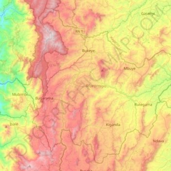
Name: Muramvya topographic map, elevation, terrain.
Location: Muramvya, Burundi (-3.42437 29.50204 -3.10670 29.85215)
Average elevation: 1,852 m
Minimum elevation: 1,029 m
Maximum elevation: 2,650 m
Other topographic maps
Click on a map to view its topography, its elevation and its terrain.
Rukuba
Burundi > Bujumbura Rural Province
Rukuba, Bujumbura Rural Province, Burundi
Average elevation: 1,288 m