
Mokhotlong District topographic map
Interactive map
Click on the map to display elevation.
About this map
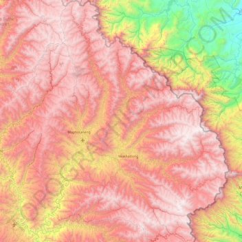
Name: Mokhotlong District topographic map, elevation, terrain.
Location: Mokhotlong District, Lesotho (-29.58166 28.55597 -28.75596 29.45571)
Average elevation: 2,435 m
Minimum elevation: 1,029 m
Maximum elevation: 3,463 m
In the east, Mokhotlong borders on the KwaZulu-Natal Province of South Africa, with its north point bordering the Free State Province. Domestically, it borders on the following districts, namely, Butha-Buthe District in northwest, Leribe District in west, and Thaba-Tseka District in the south. It is traversed by the northwesterly line of equal latitude and longitude. The Eastern districts of Lesotho has predominantly low land zone with an elevation of 1,500 m (4,900 ft) 1,800 m (5,900 ft) above the sea level. These lands are not the major agricultural zones in the country, compared to the Western counterparts. The average annual rainfall in the country is 100 cm (39 in), most of which is received during the rainy season of October to April. Though it rains during all the months of the year, groundwater is limited on account of run-offs. The region has a temperate climate (Cwb) on account of the elevation and is humid during most parts of the year. The temperature in low lands vary from 32 °C (90 °F) to −7 °C (19 °F) in the winter.
Other topographic maps
Click on a map to view its topography, its elevation and its terrain.
Botso Water Reseviour
Botso Water Reseviour, Leribe District, Lesotho
Average elevation: 2,285 m
PTC
Lesotho > Maseru District > Maseru
PTC, Maseru, Maseru District, 100, Lesotho
Average elevation: 1,649 m
Moyeni (Quthing)
Lesotho > Quthing District > Moyeni (Quthing)
Moyeni (Quthing), Quthing District, Lesotho
Average elevation: 1,644 m
Ha Long
Lesotho > Thaba-Tseka District > Ha Long
Ha Long, Thaba-Tseka District, Lesotho
Average elevation: 2,412 m
Thaba-Tseka
Lesotho > Thaba-Tseka District > Thaba-Tseka
Thaba-Tseka, Thaba-Tseka District, Lesotho
Average elevation: 2,216 m
Drakensberg
Drakensberg, Mokhotlong District, Lesotho
Average elevation: 3,286 m
Maqalika Dam
Lesotho > Maseru District > Maseru
Maqalika Dam, Maseru, Maseru District, 100, Lesotho
Average elevation: 1,540 m
Qacha's Nek
Lesotho > Qacha's Nek District > Qacha's Nek
Qacha's Nek, Qacha's Nek District, 600, Lesotho
Average elevation: 1,982 m