
Mai Maihu topographic map
Interactive map
Click on the map to display elevation.
About this map
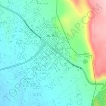
Name: Mai Maihu topographic map, elevation, terrain.
Location: Mai Maihu, Nakuru, Kenya (-0.99487 36.57370 -0.97531 36.59250)
Average elevation: 1,868 m
Minimum elevation: 1,794 m
Maximum elevation: 2,055 m
Other topographic maps
Click on a map to view its topography, its elevation and its terrain.
Longonot
Kenya > Nakuru > Naivasha > Mai Mahiu ward
Mount Longonot is protected by Kenya Wildlife Service as part of Mount Longonot National Park. A 3.1 km trail runs from the park entrance up to the crater rim, and continues in a 7.2 km loop encircling the crater. The whole tour (gate-around the rim-gate) of 13.5 km takes about 4–5 hours allowing for…
Average elevation: 2,439 m
Nakuru
On 3 June 2021, Nakuru was officially endorsed for city status after the Kenyan Senate voted for its elevation from a Municipality. The President of the Republic of Kenya will need to give a city charter for official transformation to city status. If and once given the charter, Nakuru will be the fourth city…
Average elevation: 1,993 m