
Republic of Karakalpakstan topographic map
Interactive map
Click on the map to display elevation.
About this map
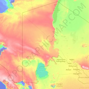
Name: Republic of Karakalpakstan topographic map, elevation, terrain.
Location: Republic of Karakalpakstan, Uzbekistan (40.99362 55.99855 45.59068 62.49867)
Average elevation: 107 m
Minimum elevation: -72 m
Maximum elevation: 410 m
Other topographic maps
Click on a map to view its topography, its elevation and its terrain.
Chirakchi
Uzbekistan > Qashqadaryo Region > Chirakchi District
It is located on the Kashkadarya River, 12 kilometers from the Yakkabag railway station, and about 500 kilometers to the south of Tashkent. The city is situated in the southwestern foothills of the Zeravshan Range at an elevation of approximately 510 meters above sea level.
Average elevation: 528 m
Jizzakh
From the slopes of the mountains at an altitude of 1800 meters above sea level, pine forests begin. As the mountains rise, the pine forest thickens.
Average elevation: 381 m
Amirsay
Uzbekistan > Tashkent Region > Bostanlik district
The Amirsoy resort covers an area of 900 hectares on the northern slope of Maygashkan Mountain, part of the Chatkal Range in the Western Tian Shan. The elevation of the ski slopes is between 1,630m and 2,275m.
Average elevation: 1,626 m
Shohimardon
Uzbekistan > Fergana Region > Fergana District
Shakhimardan City Resort is situated at 1975m above sea level, 155 km from Ferghana, in the picturesque mountainous district. The Kuliqurbon or Blue Lake is seven kilometers southeast of Shakhimardan. It was formed in 1766 after a series of extreme earthquakes. The lake is located at an altitude of 1,724…
Average elevation: 1,790 m
Katta-Kurgan
Uzbekistan > Samarqand Region > Kattaqo‘rg‘on Tumani > Katta-Kurgan
Average elevation: 491 m