
Banteay Meanchey topographic map
Interactive map
Click on the map to display elevation.
About this map
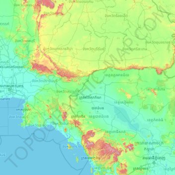
Name: Banteay Meanchey topographic map, elevation, terrain.
Location: Banteay Meanchey, Cambodia (11.19891 100.28627 16.39891 105.48627)
Average elevation: 122 m
Minimum elevation: -2 m
Maximum elevation: 1,659 m
Other topographic maps
Click on a map to view its topography, its elevation and its terrain.
Tonle Sap Lake
The land cover of the Tonlé Sap Lake Basin is 55% of the forest land and 45% of the agricultural land. The lake is surrounded by freshwater mangroves known as "flood forests", accounting for 3% of the basin area, and the floodplain is surrounded by low hills and covered with evergreen or deciduous seasonal…
Average elevation: 8 m
Mondulkiri
Mondulkiri is Cambodia's largest and also most sparsely populated province, containing an area of 14,288 km2 (5,517 sq mi) with elevations ranging from 190 to 1,000 metres (620 to 3,280 ft). It is located in the south-east part of the country and borders three provinces in Vietnam; Đắk Lắk, Đắk Nông,…
Average elevation: 254 m
Keo Seima Wildlife Sanctuary
Mixed forest types and a range of elevation gives rise to a rich collection of biodiversity, both flora and fauna. A total of 959 plant, fungi, and animal species have been recorded in the area, the highest reported number for any Cambodian protected area. A total of 356 bird species have been recorded,…
Average elevation: 201 m
Kandal
The province consists of the typical plain wet area, covering rice fields and other agricultural plantations. The average altitude of the province is no more than 10 meters above sea level. The province also features two of the biggest rivers in the country, the Bassac and Mekong Rivers.
Average elevation: 16 m
Mondulkiri
Mondulkiri is Cambodia's largest and also most sparsely populated province, containing an area of 14,288 km2 (5,517 sq mi) with elevations ranging from 190 to 1,000 metres (620 to 3,280 ft). It is located in the south-east part of the country and borders three provinces in Vietnam; Đắk Lắk, Đắk Nông,…
Average elevation: 254 m