
Kansas topographic map
Interactive map
Click on the map to display elevation.
About this map
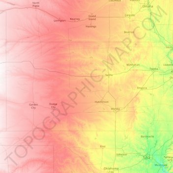
Name: Kansas topographic map, elevation, terrain.
Location: Kansas, United States (36.99307 -102.05179 40.00323 -94.58820)
Average elevation: 601 m
Minimum elevation: 150 m
Maximum elevation: 1,302 m
The western two-thirds of the state, lying in the great central plain of the United States, has a generally flat or undulating surface, while the eastern third has many hills and forests. The land gradually rises from east to west; its altitude ranges from 684 ft (208 m) along the Verdigris River at Coffeyville in Montgomery County, to 4,039 ft (1,231 m) at Mount Sunflower, 0.5 miles (0.80 kilometers) from the Colorado border, in Wallace County. It is a common misconception that Kansas is the flattest state in the nation—in 2003, a tongue-in-cheek study famously declared the state "flatter than a pancake". In fact, Kansas has a maximum topographic relief of 3,360 ft (1,020 m), making it the 23rd flattest U.S. state measured by maximum relief.
Other topographic maps
Click on a map to view its topography, its elevation and its terrain.
Los Angeles
Los Angeles, Los Angeles County, California, United States
Average elevation: 241 m
Des Moines
United States > Iowa > Polk County
Des Moines, Polk County, Iowa, United States
Average elevation: 264 m
Cochise County
Cochise County, Arizona, United States
Average elevation: 1,410 m
Lancaster County
Lancaster County, Pennsylvania, United States
Average elevation: 158 m
Joshua Tree National Park
Joshua Tree National Park, California, United States
Average elevation: 639 m
Great Smoky Mountains National Park
United States > Tennessee > Sevier County
Great Smoky Mountains National Park, Sevier County, East Tennessee, Tennessee, United States
Average elevation: 765 m
Houston
United States > Texas > Harris County
Houston, Harris County, Texas, United States
Average elevation: 25 m
Greenwich
United States > Connecticut > Western Connecticut Planning Region
Greenwich, Western Connecticut Planning Region, Connecticut, United States
Average elevation: 57 m
Hillsborough County
Hillsborough County, Florida, United States
Average elevation: 20 m
Texarkana
United States > Texas > Bowie County
Texarkana, Bowie County, Texas, United States
Average elevation: 99 m
Idaho Falls
United States > Idaho > Bonneville County
Idaho Falls, Bonneville County, Idaho, United States
Average elevation: 1,441 m
Grand Teton National Park
United States > Wyoming > Teton County
Grand Teton National Park, Teton County, Wyoming, United States
Average elevation: 2,409 m
Spokane
United States > Washington > Spokane County
Spokane, Spokane County, Washington, United States
Average elevation: 655 m
Jacksonville
United States > Florida > Duval County
Jacksonville, Duval County, Florida, United States
Average elevation: 10 m
Chamberlins
United States > Florida > Hillsborough County > Tampa
Chamberlins, Tampa, Hillsborough County, Florida, 33602, United States
Average elevation: 7 m
Cavalier Park
United States > Virginia > Virginia Beach
Cavalier Park, Virginia Beach, Virginia, 23451, United States
Average elevation: 3 m
Staten Island
United States > New York > New York
Staten Island, Richmond County, New York, United States
Average elevation: 9 m
Brooklyn
United States > New York > New York
Brooklyn, Kings County, New York, United States
Average elevation: 9 m
Appalachian Mountains
United States > North Carolina > Yancey County
Appalachian Mountains, Yancey County, North Carolina, United States
Average elevation: 1,463 m
Madison
United States > Wisconsin > Dane County
Madison, Dane County, Wisconsin, United States
Average elevation: 284 m
Middle Tennessee
Middle Tennessee, Tennessee, United States
Average elevation: 251 m
Charlotte County
Charlotte County, Florida, United States
Average elevation: 10 m
Eau Claire County
Eau Claire County, Wisconsin, United States
Average elevation: 304 m