
Westmoreland topographic map
Interactive map
Click on the map to display elevation.
Westmoreland
There are over 40 square kilometres (10,000 acres) of morass land, the largest part of which is called the Great Morass. This contains plant and animal material collected over centuries. The morass can be mined as peat, an excellent source of energy. The marsh serves as a natural and unique sanctuary for a wide variety of Jamaican wildlife and birds. The remaining area consists of several hills of moderate elevation, and alluvial plains along the coast.
About this map
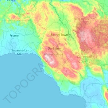
Name: Westmoreland topographic map, elevation, terrain.
Location: Westmoreland, Cornwall County, Jamaica (18.06298 -78.36893 18.35784 -77.87568)
Average elevation: 173 m
Minimum elevation: -4 m
Maximum elevation: 775 m
Other topographic maps
Click on a map to view its topography, its elevation and its terrain.
Blue Mountain Peak
The Blue Mountains are popular for hiking and camping. The traditional Blue Mountain trek is a 7-mile (11 km) hike to the peak and consists of a 3,000-foot (910 m) increase in elevation. Jamaicans prefer to reach the peak at sunrise, thus the 3- to 4-hour hike is usually undertaken in darkness. Since the sky…
Average elevation: 1,808 m