
Make a donation
Gear up for your next adventure:
As an Amazon Associate, this site earns from qualifying purchases at no extra cost to you.
Chittorgarh District topographic map
Click on the map to display elevation.
Make a donation
Gear up for your next adventure:
As an Amazon Associate, this site earns from qualifying purchases at no extra cost to you.
About this map
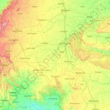
Name: Chittorgarh District topographic map, elevation, terrain.
Location: Chittorgarh District, Rajasthan, India (24.21845 74.10503 25.21565 75.81544)
Average elevation: 460 m
Minimum elevation: 173 m
Maximum elevation: 1,172 m
Make a donation
Gear up for your next adventure:
As an Amazon Associate, this site earns from qualifying purchases at no extra cost to you.
Other topographic maps
Click on a map to view its topography, its elevation and its terrain.
Make a donation
Gear up for your next adventure:
As an Amazon Associate, this site earns from qualifying purchases at no extra cost to you.
Kanor
India > Rajasthan > Vallabhnagar Tehsil
Kanore is located at 24°26′N 74°16′E / 24.43°N 74.27°E / 24.43; 74.27. It has an average elevation of 469 metres (1,539 ft).
Average elevation: 476 m
Make a donation
Gear up for your next adventure:
As an Amazon Associate, this site earns from qualifying purchases at no extra cost to you.
Make a donation
Gear up for your next adventure:
As an Amazon Associate, this site earns from qualifying purchases at no extra cost to you.
Make a donation
Gear up for your next adventure:
As an Amazon Associate, this site earns from qualifying purchases at no extra cost to you.
Pokaran
India > Rajasthan > Pokaran Tehsil
Pokhran is located 112 km east of Jaisalmer city, 172 km northwest of Jodhpur and 225 km south of Bikaner by road. It lies on Jaisalmer to Jodhpur railway line. It is situated at 27°05′42″N 71°45′11″E / 27.095°N 71.753°E / 27.095; 71.753 and has an average elevation of 233 metres (764 feet).
Average elevation: 229 m
Make a donation
Gear up for your next adventure:
As an Amazon Associate, this site earns from qualifying purchases at no extra cost to you.
Malpura
India > Rajasthan > Malpura Tehsil
Malpura is located at 26°17′N 75°23′E / 26.28°N 75.38°E / 26.28; 75.38. It has an average elevation of 132 metres (401 feet). Distance from Jaipur 90 km, Malpura is also Known for Avikanagar – 4 km from Malpura. It is famous for the Central Sheep and Wool Research Institute (CSWRI).
Average elevation: 331 m
Make a donation
Gear up for your next adventure:
As an Amazon Associate, this site earns from qualifying purchases at no extra cost to you.
Make a donation
Gear up for your next adventure:
As an Amazon Associate, this site earns from qualifying purchases at no extra cost to you.
Laxmangarh
India > Rajasthan > Lachhmangarh Tehsil
Laxmangarh is located at 27°49′21″N 75°01′31″E / 27.8225°N 75.025278°E / 27.8225; 75.025278. It has an average elevation of 222 metres (728 ft).
Average elevation: 360 m
Make a donation
Gear up for your next adventure:
As an Amazon Associate, this site earns from qualifying purchases at no extra cost to you.
Hindaun
India > Rajasthan > Hindaun Tehsil
Hindaun has an average elevation of 235 metres (771 ft). Its distance from the state capital of Jaipur is around 150 km.
Average elevation: 230 m
Make a donation
Gear up for your next adventure:
As an Amazon Associate, this site earns from qualifying purchases at no extra cost to you.
Make a donation
Gear up for your next adventure:
As an Amazon Associate, this site earns from qualifying purchases at no extra cost to you.
Nagaur
India > Rajasthan > Nagaur Tehsil
Nagaur is located at 27°12′N 73°44′E / 27.2°N 73.73°E / 27.2; 73.73. It has an average elevation of 302 metres (990 feet). Nagaur is situated amidst seven districts namely Bikaner, Churu, Sikar, Jaipur, Ajmer, Pali, Jodhpur. Nagaur is the fifth largest district in Rajasthan with a vast terrain…
Average elevation: 303 m
Behror
India > Rajasthan > Behror Tehsil
Located at co-ordinates 27°53′N 76°17′E / 27.88°N 76.28°E / 27.88; 76.28. with an average elevation of 312 metres (1,024 ft) Behror sits amidst generally plain and very fertile agricultural land with Aravali Range mountains running north–south approximately 5 km to west of Behror.
Average elevation: 318 m
Make a donation
Gear up for your next adventure:
As an Amazon Associate, this site earns from qualifying purchases at no extra cost to you.
Make a donation
Gear up for your next adventure:
As an Amazon Associate, this site earns from qualifying purchases at no extra cost to you.
Sirohi
India > Rajasthan > Sirohi Tehsil
Sirohi is located at 24°53′06″N 72°51′45″E / 24.885°N 72.8625°E / 24.885; 72.8625. It has an average elevation of 321 metres (1053 ft).
Average elevation: 321 m
Make a donation
Gear up for your next adventure:
As an Amazon Associate, this site earns from qualifying purchases at no extra cost to you.
Didwana
India > Rajasthan > Didwana Tehsil
Didwana is located at 27°24′N 74°34′E / 27.4°N 74.57°E / 27.4; 74.57. It has an average elevation of 336 metres (1102 feet). City divided in 40 Wards. It is an important station of Jodhpur-Delhi Broad gauge rail route of North West Railway Jodhpur division.
Average elevation: 343 m
Make a donation
Gear up for your next adventure:
As an Amazon Associate, this site earns from qualifying purchases at no extra cost to you.
Sheoganj
India > Rajasthan > Sheoganj Tehsil
Sheoganj is located at 25°09′N 73°04′E / 25.15°N 73.07°E / 25.15; 73.07. It has an average elevation of 260 metres (853 feet).
Average elevation: 271 m
Make a donation
Gear up for your next adventure:
As an Amazon Associate, this site earns from qualifying purchases at no extra cost to you.
Bundi
India > Rajasthan > Bundi Tehsil
The town of Bundi is situated 35 km from Kota and 210 km from Jaipur. It is located at 25°26′N 75°38′E / 25.44°N 75.64°E / 25.44; 75.64 and an average elevation of 268 metres (879 feet). The city lies near a narrow gorge, and is surrounded on three sides by hills of the Aravalli Range. A…
Average elevation: 284 m
Make a donation
Gear up for your next adventure:
As an Amazon Associate, this site earns from qualifying purchases at no extra cost to you.
Make a donation
Gear up for your next adventure:
As an Amazon Associate, this site earns from qualifying purchases at no extra cost to you.
Make a donation
Gear up for your next adventure:
As an Amazon Associate, this site earns from qualifying purchases at no extra cost to you.
Ratangarh
India > Rajasthan > Ratangarh Tehsil
Ratangarh is located at 28°05′N 74°36′E / 28.08°N 74.6°E / 28.08; 74.6. It has an average elevation of 312 metres (1023 feet).
Average elevation: 316 m
(Shree Pravshnath park )Prabhu Pravshnath nagar pal balaji
India > Rajasthan > Jodhpur Tehsil > Jodhpur
Average elevation: 231 m
Make a donation
Gear up for your next adventure:
As an Amazon Associate, this site earns from qualifying purchases at no extra cost to you.
Make a donation
Gear up for your next adventure:
As an Amazon Associate, this site earns from qualifying purchases at no extra cost to you.
Make a donation
Gear up for your next adventure:
As an Amazon Associate, this site earns from qualifying purchases at no extra cost to you.
Kotputli
India > Rajasthan > Kotpuli Tehsil
Kotputli has an average elevation of 439 meters (1,440 ft).
Average elevation: 354 m
Make a donation
Gear up for your next adventure:
As an Amazon Associate, this site earns from qualifying purchases at no extra cost to you.
Gangapur
India > Rajasthan > Gangapur Tehsil
Gangapur City is located in the eastern part of Rajasthan; it is situated 140 km from Jaipur (The Capital of Rajasthan). The city's area is about 25 km² and has an average elevation of 1,624 feet.
Average elevation: 265 m
Make a donation
Gear up for your next adventure:
As an Amazon Associate, this site earns from qualifying purchases at no extra cost to you.
Make a donation
Gear up for your next adventure:
As an Amazon Associate, this site earns from qualifying purchases at no extra cost to you.
Make a donation
Gear up for your next adventure:
As an Amazon Associate, this site earns from qualifying purchases at no extra cost to you.