
Portland topographic map
Interactive map
Click on the map to display elevation.
About this map
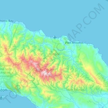
Name: Portland topographic map, elevation, terrain.
Location: Portland, Surrey County, Jamaica (17.98686 -76.75296 18.26681 -76.25798)
Average elevation: 297 m
Minimum elevation: 0 m
Maximum elevation: 2,230 m
Other topographic maps
Click on a map to view its topography, its elevation and its terrain.
Blue Mountain Peak
The Blue Mountains are popular for hiking and camping. The traditional Blue Mountain trek is a 7-mile (11 km) hike to the peak and consists of a 3,000-foot (910 m) increase in elevation. Jamaicans prefer to reach the peak at sunrise, thus the 3- to 4-hour hike is usually undertaken in darkness. Since the sky…
Average elevation: 1,808 m