
Sangli topographic map
Interactive map
Click on the map to display elevation.
About this map
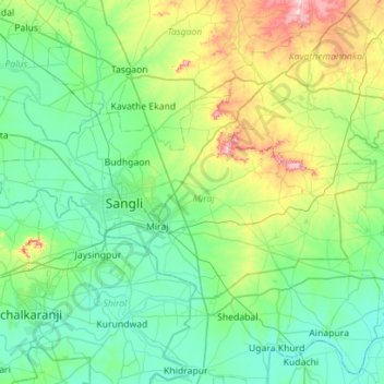
Name: Sangli topographic map, elevation, terrain.
Location: Sangli, Sangli district, Maharashtra, India (16.71489 74.40159 17.01575 74.96313)
Average elevation: 594 m
Minimum elevation: 520 m
Maximum elevation: 880 m
Other topographic maps
Click on a map to view its topography, its elevation and its terrain.
Pimpri-Chinchwad
India > Maharashtra > Haveli
Pimpri-Chinchwad also known as "PCMC", is a city in the Indian state of Maharashtra. The city is about 15 km (9.3 mi) northwest of the historic city of Pune, at an altitude of 590 m (1,940 ft) above sea level. It is the fifth largest city in Maharashtra and the nineteenth largest city in India and the…
Average elevation: 605 m
Goregaon
India > Maharashtra > Mangaon Taluka
Goregaon is located in the south-west of India at 18°10′N 73°18′E / 18.17°N 73.3°E / 18.17; 73.3. The average elevation is 28 metres (92 ft).
Average elevation: 38 m
Trimbak
India > Maharashtra > Trimbakeshwar
Trimbak is located at 19°34′N 73°19′E / 19.56°N 73.32°E / 19.56; 73.32. It has an average elevation of 720 metres (2362 feet).
Average elevation: 756 m