
Make a donation
Gear up for your next adventure:
As an Amazon Associate, this site earns from qualifying purchases at no extra cost to you.
Indonesia topographic map
Click on the map to display elevation.
Make a donation
Gear up for your next adventure:
As an Amazon Associate, this site earns from qualifying purchases at no extra cost to you.
Indonesia
Indonesia's topography is as varied as its expansive archipelago, marked by rugged mountain ranges, volcanic activity, and vast lowland plains. The majority of its major islands are mountainous, with some of the highest peaks rising above 16,000 feet (4,877 meters), such as Puncak Jaya in Papua. These mountains, part of the Pacific Ring of Fire, are often volcanic, contributing to frequent eruptions and seismic activity. The western islands, like Sumatra and Java, are particularly mountainous with steep, densely forested landscapes, while the eastern regions, such as Papua, feature towering ranges and glacial peaks. Between these highlands, Indonesia's lowlands primarily consist of coastal plains and river valleys, which are especially prominent on islands like Borneo and Sumatra. This diversity in terrain—ranging from volcanic peaks to deep sea trenches—creates a complex and dynamic landscape, fostering a unique biodiversity and a range of ecosystems across the country.
Make a donation
Gear up for your next adventure:
As an Amazon Associate, this site earns from qualifying purchases at no extra cost to you.
About this map
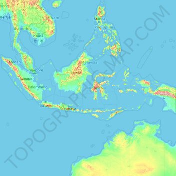
Name: Indonesia topographic map, elevation, terrain.
Location: Indonesia (-11.20857 94.77171 6.27445 141.01944)
Average elevation: 81 m
Minimum elevation: -3 m
Maximum elevation: 4,198 m
Make a donation
Gear up for your next adventure:
As an Amazon Associate, this site earns from qualifying purchases at no extra cost to you.
Other topographic maps
Click on a map to view its topography, its elevation and its terrain.
Europe
Europe's topography is characterized by a striking contrast between its rugged southern mountains and the expansive plains of the north. The continent is often described as a "peninsula of peninsulas," featuring major peninsulas like the Iberian, Italian, and Balkan, each with unique geological features. In…
Average elevation: 223 m
Istanbul
Istanbul, located in northwestern Turkey, is a city that is uniquely situated across two continents, Europe and Asia, divided by the Bosphorus Strait. The city’s topography is characterized by a complex blend of hills, valleys, and coastal plains, which create a varied and scenic landscape. The European side…
Average elevation: 57 m
Africa
Africa's topography is a complex tapestry of plateaus, mountains, valleys, and deserts. The continent is dominated by vast plateaus, with elevations averaging around 1,000 meters (3,281 feet), especially prominent in the south and east. The Ethiopian Highlands, often referred to as the "Roof of Africa," rise…
Average elevation: 462 m
Make a donation
Gear up for your next adventure:
As an Amazon Associate, this site earns from qualifying purchases at no extra cost to you.
Sochi
Russia > Krasnodar Krai > Resort Town of Sochi (municipal formation)
Sochi has a humid subtropical climate (Köppen climate classification Cfa), at the lower elevations. Its average annual temperature is 18.9 °C (66.0 °F) during the day and 11.5 °C (52.7 °F) at night. In the coldest months—January and February—the average temperature is about 10 °C (50 °F) during the…
Average elevation: 148 m
Edinburgh
United Kingdom > Scotland > Edinburgh
Some have called Edinburgh the Athens of the North for a variety of reasons. The earliest comparison between the two cities showed that they had a similar topography, with the Castle Rock of Edinburgh performing a similar role to the Athenian Acropolis. Both of them had flatter, fertile agricultural land…
Average elevation: 104 m
Make a donation
Gear up for your next adventure:
As an Amazon Associate, this site earns from qualifying purchases at no extra cost to you.
Kuala Lumpur
Located in the centre of Selangor state, Kuala Lumpur was a territory of Selangor State Government. In 1974, Kuala Lumpur was split off from Selangor to form the first Federal Territory governed directly by the Malaysian federal government. Its location in the most developed state on the west coast of…
Average elevation: 127 m
Battle of Waterloo
Belgium > Walloon Brabant > Waterloo
Waterloo was the decisive engagement of the Waterloo Campaign and Napoleon's last. According to Wellington, the battle was "the nearest-run thing you ever saw in your life". Napoleon abdicated four days later, and coalition forces entered Paris on 7 July. The defeat at Waterloo ended Napoleon's rule as Emperor…
Average elevation: 121 m
Pittsburgh
United States of America > Pennsylvania > Pittsburgh
The warmest month of the year in Pittsburgh is July, with a 24-hour average of 72.6 °F (22.6 °C). Conditions are often humid, and combined with highs reaching 90 °F (32 °C) on an average 9.5 days a year, a considerable heat index arises. The coolest month is January, when the 24-hour average is 28.4 °F…
Average elevation: 315 m
Make a donation
Gear up for your next adventure:
As an Amazon Associate, this site earns from qualifying purchases at no extra cost to you.
North America
North America's topography is characterized by its diverse and dramatic landscapes, stretching from the towering Rocky Mountains in the west to the expansive Great Plains in the central region, and the rugged Appalachian Mountains in the east. The Rocky Mountains, which include peaks exceeding 20,000 feet…
Average elevation: 294 m
United Kingdom
Scotland accounts for just under a third (32 per cent) of the total area of the UK, covering 78,772 square kilometres (30,410 sq mi). This includes nearly eight hundred islands, predominantly west and north of the mainland; notably the Hebrides, Orkney Islands and Shetland Islands. Scotland is the most…
Average elevation: 79 m
Make a donation
Gear up for your next adventure:
As an Amazon Associate, this site earns from qualifying purchases at no extra cost to you.
Athens
Greece > Attica > Regional Unit of Central Athens
Owing to the rain shadow of the Pindus Mountains, annual precipitation of Athens is lower than most other parts of Greece, especially western Greece. As an example, Ioannina receives around 1,300 mm (51 in) per year, and Agrinio around 800 mm (31 in) per year. Daily average highs for July have been measured…
Average elevation: 168 m
City of London
United Kingdom > England > City of London > City of London
The elevation of the City ranges from sea level at the Thames to 21.6 metres (71 ft) at the junction of High Holborn and Chancery Lane. Two small but notable hills are within the historic core, Ludgate Hill to the west and Cornhill to the east. Between them ran the Walbrook, one of the many "lost" rivers or…
Average elevation: 42 m
Make a donation
Gear up for your next adventure:
As an Amazon Associate, this site earns from qualifying purchases at no extra cost to you.
Hamburg
The neighborhoods of Neuenfelde, Cranz, Francop and Finkenwerder are part of the Altes Land (old land) region, the largest contiguous fruit-producing region in Central Europe. Neugraben-Fischbek has Hamburg's highest elevation, the Hasselbrack at 116.2 metres (381 ft) AMSL. Hamburg borders the states of…
Average elevation: 23 m
Cluj-Napoca
A wide variety of flora grow in the Cluj-Napoca Botanical Garden; some animals have also found refuge there. The city has a number of other parks, of which the largest is the Central Park. This park was founded during the 19th century and includes an artificial lake with an island, as well as the largest…
Average elevation: 490 m
Make a donation
Gear up for your next adventure:
As an Amazon Associate, this site earns from qualifying purchases at no extra cost to you.
Mexico City
Mexico is crossed from north to south by two mountain ranges known as Sierra Madre Oriental and Sierra Madre Occidental, which are the extension of the Rocky Mountains from northern North America. From east to west at the center, the country is crossed by the Trans-Mexican Volcanic Belt also known as the…
Average elevation: 2,321 m
Aberdeen
United Kingdom > Scotland > Aberdeen
Two weather stations collect climate data for the area, Aberdeen/Dyce Airport, and Craibstone. Both are about 4 1⁄2 miles (7 km) to the north west of the city centre, and given that they are in close proximity to each other, exhibit very similar climatic regimes. Dyce tends to have marginally warmer daytime…
Average elevation: 52 m
Make a donation
Gear up for your next adventure:
As an Amazon Associate, this site earns from qualifying purchases at no extra cost to you.
Gran Paradiso
Italy > Aosta Valley > Valsavarenche
The peak is the 7th highest mountain in the Graian Alps, with an elevation of 4,061 m. In the SOIUSA (International Standardized Mountain Subdivision of the Alps) the mountain belongs to an alpine subsection called "North-Eastern Graian Alps" (It:Alpi del Gran Paradiso; Fr:Alpes du Grand-Paradis) and also…
Average elevation: 3,459 m
Make a donation
Gear up for your next adventure:
As an Amazon Associate, this site earns from qualifying purchases at no extra cost to you.
Little Saint James Island
United States > United States Virgin Islands > Saint Thomas - Saint John District
Average elevation: 1 m
Asia
Average elevation: 563 m
Make a donation
Gear up for your next adventure:
As an Amazon Associate, this site earns from qualifying purchases at no extra cost to you.
Mount Everest
Nepal > Koshi Province > Solukhumbu
Mount Everest (Nepali: सगरमाथा, romanized: Sagarmāthā; Standard Tibetan: ཇོ་མོ་གླང་མ, romanized: Chomolungma; Chinese: 珠穆朗玛峰; pinyin: Zhūmùlǎngmǎ Fēng) is Earth's highest mountain above sea level, located in the Mahalangur Himal sub-range of the Himalayas.…
Average elevation: 7,847 m
Portsmouth
United Kingdom > England > Hampshire > Portsmouth
By road, Portsmouth lies 73.5 miles (118.3 km) from Central London, 49.5 miles (79.7 km) west of Brighton, and 22.3 miles (35.9 km) east of Southampton. Portsmouth is situated primarily on Portsea Island and is the United Kingdom's only island city, although parts of it have expanded onto the mainland. Gosport…
Average elevation: 28 m
Aarhus
Denmark > Central Denmark Region
Western winds from the Atlantic and North Sea are dominant resulting in more precipitation in western Denmark. In addition, Jutland rises sufficiently in the centre to lift air to higher, colder altitudes contributing to increased precipitation in eastern Jutland. Combined, these factors make east and south…
Average elevation: 35 m
Make a donation
Gear up for your next adventure:
As an Amazon Associate, this site earns from qualifying purchases at no extra cost to you.
Make a donation
Gear up for your next adventure:
As an Amazon Associate, this site earns from qualifying purchases at no extra cost to you.
Montgomery
United States of America > Alabama > Montgomery
Montgomery is located at 32°21′42″N 86°16′45″W / 32.36167°N 86.27917°W / 32.36167; -86.27917. According to the U.S. Census Bureau, the city has a total area of 156.2 square miles (405 km2), of which 155.4 square miles (402 km2) is land and 0.8 square miles (2.1 km2) (0.52%) is water. The…
Average elevation: 68 m
Ural Mountains
Russia > Khanty-Mansiysk Autonomous Okrug – Ugra > Beryozovsky District
The Ural Mountains (/ˈjʊərəl/ YOOR-əl; Russian: Ура́льские го́ры, tr. Uralskiye gory, IPA: [ʊˈralʲskʲɪjə ˈɡorɨ]; Bashkir: Урал тауҙары) or simply the Urals, are a mountain range in Eurasia that runs north-south mostly through Russia, from the coast of the Arctic Ocean to…
Average elevation: 1,435 m
Bogota
The city is located in the center of Colombia, on a high plateau known as the Bogotá savanna, part of the Altiplano Cundiboyacense located in the Eastern Cordillera of the Andes. Its altitude averages 2,640 meters (8,660 ft) above sea level. Subdivided into 20 localities, Bogotá has an area of 1,587 square…
Average elevation: 2,735 m
Baltimore
United States > Maryland > Baltimore
Baltimore is in north-central Maryland on the Patapsco River close to where it empties into the Chesapeake Bay. The city is also located on the fall line between the Piedmont Plateau and the Atlantic coastal plain, which divides Baltimore into "lower city" and "upper city". The city's elevation ranges from sea…
Average elevation: 65 m
Make a donation
Gear up for your next adventure:
As an Amazon Associate, this site earns from qualifying purchases at no extra cost to you.
Make a donation
Gear up for your next adventure:
As an Amazon Associate, this site earns from qualifying purchases at no extra cost to you.
British Isles
The oldest rocks are 2.7 billion years old and are found in Ireland, Wales and the northwest of Scotland. During the Silurian period, the north-western regions collided with the south-east, which had been part of a separate continental landmass. The topography of the islands is modest in scale by global…
Average elevation: 25 m
Virginia Beach
United States > Virginia > Virginia Beach
According to the United States Census Bureau, the city has a total area of 497 square miles (1,290 km2), of which 249 square miles (640 km2) is land and 248 square miles (640 km2) (49.9%) is water. It is the largest city in Virginia by total area and third-largest city land area. The average elevation is 12…
Average elevation: 2 m
Swansea
United Kingdom > Wales > Swansea
Much of Swansea is hilly with the main area of upland being located in the council ward of Mawr. Areas up to 185 metres (607 ft) in elevation range across the central section: Kilvey Hill, Townhill and Llwynmawr separate the centre of Swansea from its northern suburbs. Cefn Bryn, a ridge of high land, is the…
Average elevation: 73 m
Make a donation
Gear up for your next adventure:
As an Amazon Associate, this site earns from qualifying purchases at no extra cost to you.
Thuvakudi
India > Tamil Nadu > Thiruverumbur
Thuvakudi is located at 10°45′23″N 78°48′04″E / 10.756389°N 78.801111°E / 10.756389; 78.801111. The average elevation is 88 metres (289 ft). The topology of Thuvakudi is almost flat with a few isolated hillocks rising above the surface. The city spread over an area of 14.371 square…
Average elevation: 78 m
Make a donation
Gear up for your next adventure:
As an Amazon Associate, this site earns from qualifying purchases at no extra cost to you.
Mount Wallace
Average elevation: 323 m
Make a donation
Gear up for your next adventure:
As an Amazon Associate, this site earns from qualifying purchases at no extra cost to you.
Boise
United States > Idaho > Ada County
Boise (locally /ˈbɔɪsi/ BOY-see) is the capital and most populous city of the U.S. state of Idaho and is the county seat of Ada County. As of the 2020 census, there were 235,684 people residing in the city. On the Boise River in southwestern Idaho, it is 41 miles (66 km) east of the Oregon border and 110…
Average elevation: 1,040 m
South America
The east-central Brazilian plateau has a humid and warm tropical climate. The northern and eastern parts of the Argentine pampas have a humid subtropical climate with dry winters and humid summers of the Chinese type, while the western and eastern ranges have a subtropical climate of the dinaric type. At the…
Average elevation: 283 m
Make a donation
Gear up for your next adventure:
As an Amazon Associate, this site earns from qualifying purchases at no extra cost to you.
Appalachian Mountains
United States > North Carolina > Yancey County
The Appalachian Mountains (French: Appalaches), often called the Appalachians, are a system of mountains in eastern to northeastern North America. The Appalachians first formed roughly 480 million years ago during the Ordovician Period. They once reached elevations similar to those of the Alps and the Rocky…
Average elevation: 1,463 m
Scafell Pike
United Kingdom > England > Cumberland
Scafell Pike (/ˈskɔːfɛl paɪk/) is the highest and the most prominent mountain in England, at an elevation of 978 metres (3,209 ft) above sea level. It is located in the Lake District National Park, in Cumbria, and is part of the Southern Fells and the Scafell massif.
Average elevation: 679 m
Kisumu
Kisumu literally means a place of barter trade "sumo". The city has "Friendship" status with Cheltenham, United Kingdom and "sister city" status with Roanoke, Virginia and Boulder, Colorado, United States. It sits at an elevation of 1,131 m (3,711 ft). Kisumu is 200 miles north west of Nairobi and its located…
Average elevation: 1,219 m
Riyadh
Riyadh has a hot desert climate (Köppen Climate Classification BWh), with long, extremely hot summers and short, very mild winters. The average high temperature in August is 43.6 °C (110.5 °F). If it was not for the elevation the city was on, Riyadh would experience an even hotter climate. The city…
Average elevation: 630 m
Make a donation
Gear up for your next adventure:
As an Amazon Associate, this site earns from qualifying purchases at no extra cost to you.
Make a donation
Gear up for your next adventure:
As an Amazon Associate, this site earns from qualifying purchases at no extra cost to you.
Cambridge
United Kingdom > England > Cambridge
The city, like most of the UK, has a maritime climate highly influenced by the Gulf Stream. Located in the driest region of Britain, Cambridge's rainfall averages around 570 mm (22.44 in) per year, around half the national average, with some years occasionally falling into the semi-arid (under 500 mm (19.69…
Average elevation: 18 m
Hull
United Kingdom > England > Kingston upon Hull
Kingston upon Hull is on the northern bank of the Humber Estuary. The city centre is west of the River Hull and close to the Humber. The city is built upon alluvial and glacial deposits which overlie chalk rocks but the underlying chalk has no influence on the topography. The land within the city is generally…
Average elevation: 21 m
Make a donation
Gear up for your next adventure:
As an Amazon Associate, this site earns from qualifying purchases at no extra cost to you.
Columbus
United States > Ohio > Franklin County > Columbus
The confluence of the Scioto and Olentangy rivers is just north-west of Downtown Columbus. Several smaller tributaries course through the Columbus metropolitan area, including Alum Creek, Big Walnut Creek, and Darby Creek. Columbus is considered to have relatively flat topography thanks to a large glacier that…
Average elevation: 255 m
Leeds
Lying in the eastern foothills of the Pennines, there is a significant variation in elevation within the city's built-up area. The district ranges from 1,115 feet (340 m) in the far west on the slopes of Ilkley Moor to about 33 feet (10 m) where the rivers Aire and Wharfe cross the eastern boundary. Land rises…
Average elevation: 94 m
Pimpri-Chinchwad
India > Maharashtra > Haveli
Pimpri-Chinchwad also known as "PCMC", is a city in the Indian state of Maharashtra. The city is about 15 km (9.3 mi) northwest of the historic city of Pune, at an altitude of 590 m (1,940 ft) above sea level. It is the fifth largest city in Maharashtra and the nineteenth largest city in India and the…
Average elevation: 605 m
Dubai
Dubai lies directly within the Arabian Desert. However, the topography of Dubai is significantly different from that of the southern portion of the UAE in that much of Dubai's landscape is highlighted by sandy desert patterns, while gravel deserts dominate much of the southern region of the country. The sand…
Average elevation: 7 m
Make a donation
Gear up for your next adventure:
As an Amazon Associate, this site earns from qualifying purchases at no extra cost to you.
Adelaide
Australia > South Australia > Adelaide
South Australia was officially established as a British Province in England in February 1836. The first Governor proclaimed the commencement of colonial government in South Australia on 28 December 1836, near The Old Gum Tree in what is now the suburb of Glenelg North. The event is commemorated in South…
Average elevation: 148 m
Make a donation
Gear up for your next adventure:
As an Amazon Associate, this site earns from qualifying purchases at no extra cost to you.
Berlin
Berlin straddles the banks of the River Spree, which flows into the River Havel (a tributary of the River Elbe) in the western borough of Spandau. Among the city's main topographical features are the many lakes in the western and southeastern boroughs formed by the Spree, Havel, and Dahme rivers (the largest…
Average elevation: 47 m
Make a donation
Gear up for your next adventure:
As an Amazon Associate, this site earns from qualifying purchases at no extra cost to you.
Peterborough
United Kingdom > England > Cambridgeshire
The local topography is flat, and in some places, the land lies below sea level, for example in parts of the Fens to the east and to the south of Peterborough. Human settlement in the area began before the Bronze Age, as can be seen at the Flag Fen archaeological site to the east of the current city centre,…
Average elevation: 17 m
Make a donation
Gear up for your next adventure:
As an Amazon Associate, this site earns from qualifying purchases at no extra cost to you.
Vrindavan
India > Uttar Pradesh > Mathura
Situated on the west bank of the Yamuna River, about 15 kilometres north of Mathura and 125 km from Delhi, Vrindavan has an average elevation of 170 metres (557 feet). The Yamuna river flows through the city.
Average elevation: 172 m
Make a donation
Gear up for your next adventure:
As an Amazon Associate, this site earns from qualifying purchases at no extra cost to you.