
Make a donation
Gear up for your next adventure:
As an Amazon Associate, this site earns from qualifying purchases at no extra cost to you.
Bhutan topographic map
Click on the map to display elevation.
Make a donation
Gear up for your next adventure:
As an Amazon Associate, this site earns from qualifying purchases at no extra cost to you.
Bhutan
Bhutan is on the southern slopes of the eastern Himalayas, landlocked between the Tibet Autonomous Region of China to the north and the Indian states of Sikkim, West Bengal, Assam to the west and south, and the Indian state of Arunachal Pradesh to the east. It lies between latitudes 26°N and 29°N, and longitudes 88°E and 93°E. The land consists mostly of steep and high mountains crisscrossed by a network of swift rivers that form deep valleys before draining into the Indian plains. In fact, 98.8% of Bhutan is covered by mountains, which makes it the most mountainous country in the world. Elevation rises from 200 m (660 ft) in the southern foothills to more than 7,000 m (23,000 ft). This great geographical diversity combined with equally diverse climate conditions contributes to Bhutan's outstanding range of biodiversity and ecosystems.
Make a donation
Gear up for your next adventure:
As an Amazon Associate, this site earns from qualifying purchases at no extra cost to you.
About this map
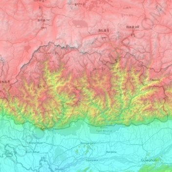
Name: Bhutan topographic map, elevation, terrain.
Location: Bhutan (26.70147 88.74624 28.24742 92.12523)
Average elevation: 2,736 m
Minimum elevation: 24 m
Maximum elevation: 7,385 m
Make a donation
Gear up for your next adventure:
As an Amazon Associate, this site earns from qualifying purchases at no extra cost to you.
Other topographic maps
Click on a map to view its topography, its elevation and its terrain.
Europe
Europe's topography is characterized by a striking contrast between its rugged southern mountains and the expansive plains of the north. The continent is often described as a "peninsula of peninsulas," featuring major peninsulas like the Iberian, Italian, and Balkan, each with unique geological features. In…
Average elevation: 223 m
Istanbul
Istanbul, located in northwestern Turkey, is a city that is uniquely situated across two continents, Europe and Asia, divided by the Bosphorus Strait. The city’s topography is characterized by a complex blend of hills, valleys, and coastal plains, which create a varied and scenic landscape. The European side…
Average elevation: 57 m
Africa
Africa's topography is a complex tapestry of plateaus, mountains, valleys, and deserts. The continent is dominated by vast plateaus, with elevations averaging around 1,000 meters (3,281 feet), especially prominent in the south and east. The Ethiopian Highlands, often referred to as the "Roof of Africa," rise…
Average elevation: 462 m
Make a donation
Gear up for your next adventure:
As an Amazon Associate, this site earns from qualifying purchases at no extra cost to you.
North America
North America's topography is characterized by its diverse and dramatic landscapes, stretching from the towering Rocky Mountains in the west to the expansive Great Plains in the central region, and the rugged Appalachian Mountains in the east. The Rocky Mountains, which include peaks exceeding 20,000 feet…
Average elevation: 294 m
Edinburgh
United Kingdom > Scotland > Edinburgh
Some have called Edinburgh the Athens of the North for a variety of reasons. The earliest comparison between the two cities showed that they had a similar topography, with the Castle Rock of Edinburgh performing a similar role to the Athenian Acropolis. Both of them had flatter, fertile agricultural land…
Average elevation: 104 m
United Kingdom
Scotland accounts for just under a third (32 per cent) of the total area of the UK, covering 78,772 square kilometres (30,410 sq mi). This includes nearly eight hundred islands, predominantly west and north of the mainland; notably the Hebrides, Orkney Islands and Shetland Islands. Scotland is the most…
Average elevation: 79 m
Make a donation
Gear up for your next adventure:
As an Amazon Associate, this site earns from qualifying purchases at no extra cost to you.
Glasgow
United Kingdom > Scotland > Glasgow City
Glasgow itself was reputed to have been founded by the Christian missionary Saint Mungo in the 6th century. He established a church on the Molendinar Burn, where the present Glasgow Cathedral stands, and in the following years Glasgow became a religious centre. Glasgow grew over the following centuries. The…
Average elevation: 128 m
Appalachian Mountains
United States > North Carolina > Yancey County
The Appalachian Mountains (French: Appalaches), often called the Appalachians, are a system of mountains in eastern to northeastern North America. The Appalachians first formed roughly 480 million years ago during the Ordovician Period. They once reached elevations similar to those of the Alps and the Rocky…
Average elevation: 1,463 m
Cambridge
United Kingdom > England > Cambridge
The city, like most of the UK, has a maritime climate highly influenced by the Gulf Stream. Located in the driest region of Britain, Cambridge's rainfall averages around 570 mm (22.44 in) per year, around half the national average, with some years occasionally falling into the semi-arid (under 500 mm (19.69…
Average elevation: 18 m
Make a donation
Gear up for your next adventure:
As an Amazon Associate, this site earns from qualifying purchases at no extra cost to you.
Mexico City
Mexico is crossed from north to south by two mountain ranges known as Sierra Madre Oriental and Sierra Madre Occidental, which are the extension of the Rocky Mountains from northern North America. From east to west at the center, the country is crossed by the Trans-Mexican Volcanic Belt also known as the…
Average elevation: 2,321 m
South America
The east-central Brazilian plateau has a humid and warm tropical climate. The northern and eastern parts of the Argentine pampas have a humid subtropical climate with dry winters and humid summers of the Chinese type, while the western and eastern ranges have a subtropical climate of the dinaric type. At the…
Average elevation: 283 m
Make a donation
Gear up for your next adventure:
As an Amazon Associate, this site earns from qualifying purchases at no extra cost to you.
Berlin
Berlin straddles the banks of the River Spree, which flows into the River Havel (a tributary of the River Elbe) in the western borough of Spandau. Among the city's main topographical features are the many lakes in the western and southeastern boroughs formed by the Spree, Havel, and Dahme rivers (the largest…
Average elevation: 47 m
Make a donation
Gear up for your next adventure:
As an Amazon Associate, this site earns from qualifying purchases at no extra cost to you.
Asia
Average elevation: 563 m
Soweto
South Africa > Gauteng > City of Johannesburg Metropolitan Municipality
Average elevation: 1,638 m
Athens
Greece > Attica > Regional Unit of Central Athens
Owing to the rain shadow of the Pindus Mountains, annual precipitation of Athens is lower than most other parts of Greece, especially western Greece. As an example, Ioannina receives around 1,300 mm (51 in) per year, and Agrinio around 800 mm (31 in) per year. Daily average highs for July have been measured…
Average elevation: 168 m
Make a donation
Gear up for your next adventure:
As an Amazon Associate, this site earns from qualifying purchases at no extra cost to you.
Amman
Jordan > Amman > Amman Sub-District
Amman is situated on the East Bank Plateau, an upland characterized by three major wadis which run through it. Originally, the city had been built on seven hills. Amman's terrain is typified by its mountains. The most important areas in the city are named after the hills or mountains they lie on. The area's…
Average elevation: 800 m
Chongqing
The central urban area of Chongqing, or Chongqing proper, is a city of unique features. Built on mountains and partially surrounded by the Yangtze and Jialing rivers, it is known as a "mountain city" and a "city on rivers". The night scene of the city is very illuminated, with millions of lights and their…
Average elevation: 318 m
Make a donation
Gear up for your next adventure:
As an Amazon Associate, this site earns from qualifying purchases at no extra cost to you.
Johannesburg
South Africa > Gauteng > City of Johannesburg Metropolitan Municipality
Johannesburg is located in the eastern plateau area of South Africa known as the Highveld, at an elevation of 1,753 metres (5,751 ft). The former Central Business District is located on the southern side of the prominent ridge called the Witwatersrand (English: White Water's Ridge) and the terrain falls to the…
Average elevation: 1,615 m
Ben Nevis
United Kingdom > Scotland > Highland
Ben Nevis has a highland (alpine) maritime (oceanic) polar climate (ET climate in the Köppen classification). Ben Nevis's elevation, maritime location and topography frequently lead to cool and cloudy weather conditions, which can pose a danger to ill-equipped walkers. According to the observations carried…
Average elevation: 912 m
Perth
Perth, the capital of Western Australia, is situated on the Swan Coastal Plain, a flat expanse of sandy soil nestled between the Indian Ocean to the west and the Darling Scarp to the east. The Darling Scarp, also known as the Darling Range, is a low escarpment that extends north–south, marking a distinct…
Average elevation: 26 m
Make a donation
Gear up for your next adventure:
As an Amazon Associate, this site earns from qualifying purchases at no extra cost to you.
Swindon
United Kingdom > England > Swindon
Swindon has an oceanic climate (Cfb in the Köppen climate classification), like the vast majority of the British Isles, with cool winters and warm summers. The nearest official weather station is RAF Lyneham, about 10 miles (16 km) west southwest of Swindon town centre. The weather station's elevation is 145…
Average elevation: 108 m
Make a donation
Gear up for your next adventure:
As an Amazon Associate, this site earns from qualifying purchases at no extra cost to you.
Bhubaneshwar
India > Odisha > Bhubaneswar (M.Corp.)
Bhubaneswar is in Khordha district of Odisha. It is in the eastern coastal plains, along the axis of the Eastern Ghats mountains. The city has an average altitude of 45 m (148 ft) above sea level. It lies southwest of the Mahanadi River that forms the northern boundary of Bhubaneswar metropolitan area, within…
Average elevation: 30 m
Make a donation
Gear up for your next adventure:
As an Amazon Associate, this site earns from qualifying purchases at no extra cost to you.
Himalayas
Nepal > Koshi Province > Solukhumbu
The Himalayas, or Himalaya (/ˌhɪməˈleɪ.ə, hɪˈmɑːləjə/; Sanskrit: [ɦɪmaːlɐjɐ]; from Sanskrit himá 'snow, frost', and ā-laya 'dwelling, abode'), is a mountain range in Asia, separating the plains of the Indian subcontinent from the Tibetan Plateau. The range has some of the planet's highest…
Average elevation: 7,555 m
Mount Everest
Nepal > Eastern Development Region > Qutang > Khumjung
Mount Everest (Chinese: 珠穆朗玛 Zhūmùlǎngmǎ; Nepali: सगरमाथा, romanized: Sagarmāthā; Tibetan: Chomolungma ཇོ་མོ་གླང་མ) is Earth's highest mountain above sea level, located in the Mahalangur Himal sub-range of the Himalayas. The China–Nepal border runs across its…
Average elevation: 7,841 m
Virginia Beach
United States > Virginia > Virginia Beach
According to the United States Census Bureau, the city has a total area of 497 square miles (1,290 km2), of which 249 square miles (640 km2) is land and 248 square miles (640 km2) (49.9%) is water. It is the largest city in Virginia by total area and third-largest city land area. The average elevation is 12…
Average elevation: 2 m
Make a donation
Gear up for your next adventure:
As an Amazon Associate, this site earns from qualifying purchases at no extra cost to you.
Cape Town
South Africa > Western Cape > City of Cape Town
The Cape Peninsula is 52 km long from Mouille Point in the north to Cape Point in the south, with an area of about 470 km2, and it displays more topographical variety than other similar sized areas in southern Africa, and consequently spectacular scenery. There are diverse low-nutrient soils, large rocky…
Average elevation: 53 m
Hull
United Kingdom > England > Kingston upon Hull
Kingston upon Hull is on the northern bank of the Humber Estuary. The city centre is west of the River Hull and close to the Humber. The city is built upon alluvial and glacial deposits which overlie chalk rocks but the underlying chalk has no influence on the topography. The land within the city is generally…
Average elevation: 21 m
Leeds
Lying in the eastern foothills of the Pennines, there is a significant variation in elevation within the city's built-up area. The district ranges from 1,115 feet (340 m) in the far west on the slopes of Ilkley Moor to about 33 feet (10 m) where the rivers Aire and Wharfe cross the eastern boundary. Land rises…
Average elevation: 94 m
Santiago
Chile > Santiago Metropolitan Region > Provincia de Santiago
The city lies in the center of the Santiago Basin, a large bowl-shaped valley consisting of broad and fertile lands surrounded by mountains. The city has a varying elevation, gradually increasing from 400 m (1,312 ft) in the western areas to more than 700 m (2,297 ft) in the eastern areas. Santiago's…
Average elevation: 722 m
Make a donation
Gear up for your next adventure:
As an Amazon Associate, this site earns from qualifying purchases at no extra cost to you.
Bogota
The city is located in the center of Colombia, on a high plateau known as the Bogotá savanna, part of the Altiplano Cundiboyacense located in the Eastern Cordillera of the Andes. Its altitude averages 2,640 meters (8,660 ft) above sea level. Subdivided into 20 localities, Bogotá has an area of 1,587 square…
Average elevation: 2,735 m
Aarhus
Denmark > Central Denmark Region
Western winds from the Atlantic and North Sea are dominant resulting in more precipitation in western Denmark. In addition, Jutland rises sufficiently in the centre to lift air to higher, colder altitudes contributing to increased precipitation in eastern Jutland. Combined, these factors make east and south…
Average elevation: 35 m
Kolkata
Spread roughly north–south along the east bank of the Hooghly River, Kolkata sits within the lower Ganges Delta of eastern India approximately 75 km (47 mi) west of the international border with Bangladesh; the city's elevation is 1.5–9 m (5–30 ft). Much of the city was originally a wetland that was…
Average elevation: 5 m
Make a donation
Gear up for your next adventure:
As an Amazon Associate, this site earns from qualifying purchases at no extra cost to you.
Kuala Lumpur
Located in the centre of Selangor state, Kuala Lumpur was a territory of Selangor State Government. In 1974, Kuala Lumpur was split off from Selangor to form the first Federal Territory governed directly by the Malaysian federal government. Its location in the most developed state on the west coast of…
Average elevation: 127 m
Make a donation
Gear up for your next adventure:
As an Amazon Associate, this site earns from qualifying purchases at no extra cost to you.
Florida Keys
United States > Florida > Monroe County
Tropical cyclones present special dangers and challenges to the entire Keys. Because no area of the islands is more than 20 feet (6.1 m) above sea level (and many are only a few feet elevation), and water surrounds the islands, nearly every neighborhood is subject to flooding as well as hurricane winds. In…
Average elevation: 0 m
Mount Hood
United States > Oregon > Hood River County
Timberline Lodge is a National Historic Landmark located on the southern flank of Mount Hood just below Palmer Glacier, with an elevation of about 6,000 ft (1,800 m).
Average elevation: 2,716 m
Make a donation
Gear up for your next adventure:
As an Amazon Associate, this site earns from qualifying purchases at no extra cost to you.
Baltimore
United States > Maryland > Baltimore
Baltimore is in north-central Maryland on the Patapsco River close to where it empties into the Chesapeake Bay. The city is also located on the fall line between the Piedmont Plateau and the Atlantic coastal plain, which divides Baltimore into "lower city" and "upper city". The city's elevation ranges from sea…
Average elevation: 65 m
Dundee
United Kingdom > Scotland > Dundee City
Dundee sits on the north bank of the Firth of Tay on the eastern, North Sea Coast of Scotland. The city lies 36.1 miles (58 km) NNE of Edinburgh and 360.6 miles (580 km) NNW of London. The built-up area occupies a roughly rectangular shape 8.3 miles (13 km) long by 2.5 miles (4 km) wide, aligned in an east to…
Average elevation: 82 m
Make a donation
Gear up for your next adventure:
As an Amazon Associate, this site earns from qualifying purchases at no extra cost to you.
Sahel
The topography of the Sahel is mainly flat; most of the region lies between 200 and 400 meters (660 and 1,310 ft) in elevation. Several isolated plateaus and mountain ranges rise from the Sahel, but are designated as separate ecoregions because their flora and fauna are distinct from the surrounding lowlands.…
Average elevation: 279 m
Pittsburgh
United States of America > Pennsylvania > Pittsburgh
The warmest month of the year in Pittsburgh is July, with a 24-hour average of 72.6 °F (22.6 °C). Conditions are often humid, and combined with highs reaching 90 °F (32 °C) on an average 9.5 days a year, a considerable heat index arises. The coolest month is January, when the 24-hour average is 28.4 °F…
Average elevation: 315 m
Antalya
While the city itself only has modest elevation changes, Antalya has high mountains in all directions to its interior. With moisture being trapped, the local climate thus has high winter rainfall, while the interior bay setting result in very hot summers for a coastal city.
Average elevation: 117 m
Make a donation
Gear up for your next adventure:
As an Amazon Associate, this site earns from qualifying purchases at no extra cost to you.
Haifa
Haifa is the center of liberal Arabic-speaking culture, as it was under British colonial rule. The Arabic-speaking neighborhoods, which are mixed Muslim and Christian, are in the lowlands near the sea, while Jewish neighborhoods are at higher elevation. An active Arab cultural life has developed in the 21st…
Average elevation: 100 m
Scottsdale
United States > Arizona > Maricopa County > Scottsdale
The city is in the Salt River Valley, or the "Valley of the Sun," in the northern reaches of the Sonoran Desert. Scottsdale, 31 mi (50 km) long and 11.4 mi (18.3 km) wide at its widest point, shares boundaries with many other municipalities and entities. On the west, Scottsdale is bordered by Phoenix, Paradise…
Average elevation: 414 m
Hawassa
Hawassa (Amharic: አዋሳ; ʾäwasa, also spelled Awassa or Awasa) known historically as Adare is a city in Ethiopia, on the shores of Lake Awassa in the Great Rift Valley. It is 273 km (170 mi) south of Addis Ababa via Bishoftu, 130 km (81 mi) east of Sodo, and 75 km (47 mi) north of Dilla. The town serves…
Average elevation: 1,862 m
Make a donation
Gear up for your next adventure:
As an Amazon Associate, this site earns from qualifying purchases at no extra cost to you.
Lakewood
United States > Colorado > Jefferson County > Lakewood
Lakewood is located at 39°42′17″N 105°04′53″W / 39.70472°N 105.08139°W / 39.70472; -105.08139 at an elevation of 5,518 feet (1,682 m). Located at the junction of U.S. Route 6 and Colorado State Highway 121 in central Colorado, the city lies immediately west of Denver and 62 miles (100 km)…
Average elevation: 1,717 m
Make a donation
Gear up for your next adventure:
As an Amazon Associate, this site earns from qualifying purchases at no extra cost to you.
Riyadh
Riyadh has a hot desert climate (Köppen Climate Classification BWh), with long, extremely hot summers and short, very mild winters. The average high temperature in August is 43.6 °C (110.5 °F). If it was not for the elevation the city was on, Riyadh would experience an even hotter climate. The city…
Average elevation: 630 m
Little Saint James Island
United States > United States Virgin Islands > Saint Thomas - Saint John District
Average elevation: 1 m
Make a donation
Gear up for your next adventure:
As an Amazon Associate, this site earns from qualifying purchases at no extra cost to you.
Mysuru
India > Karnataka > Mysuru taluk
Mysore (/maɪˈsɔːr/ (listen)), officially Mysuru ([ˈmaɪˈsuːɾu] (listen)), is a city in the southern part of the state of Karnataka, India. Mysore city is geographically located between 12° 18′ 26″ north latitude and 76° 38′ 59″ east longitude. It is located at an altitude of 770 m (2,530 ft)…
Average elevation: 727 m
Atlantic Ocean
In 1922 a historic moment in cartography and oceanography occurred. The USS Stewart used a Navy Sonic Depth Finder to draw a continuous map across the bed of the Atlantic. This involved little guesswork because the idea of sonar is straight forward with pulses being sent from the vessel, which bounce off the…
Average elevation: 0 m
Make a donation
Gear up for your next adventure:
As an Amazon Associate, this site earns from qualifying purchases at no extra cost to you.
Mount Elbrus (West Summit)
Russia > Karachay-Cherkessia > Karachayevsky District
As Elbrus is located in the Northern Hemisphere, the summer period takes place from June to mid-September, with an average of 50% of sunny days favorable to the ascent of the summit. However, the winds, dominated by westerly air masses, can turn violent and temperatures drop very quickly. Above 4000 meters…
Average elevation: 5,161 m
Kefalonia
Greece > Peloponnese, Western Greece and the Ionian > Kefallonia Regional Unit
Average elevation: 60 m
Make a donation
Gear up for your next adventure:
As an Amazon Associate, this site earns from qualifying purchases at no extra cost to you.
Central Park
United States > New York > New York County > New York
In June 1856, Fernando Wood appointed a "consulting board" of seven people, headed by author Washington Irving, to inspire public confidence in the proposed development. Wood hired military engineer Egbert Ludovicus Viele as the park's chief engineer, tasking him with a topographical survey of the site. The…
Average elevation: 26 m
Make a donation
Gear up for your next adventure:
As an Amazon Associate, this site earns from qualifying purchases at no extra cost to you.
Estes Park
United States > Colorado > Larimer County
Estes Park sits at an elevation of 7,522 feet (2,293 m) on the front range of the Rocky Mountains at the eastern entrance of the Rocky Mountain National Park. Its north, south and east extremities border the Roosevelt National Forest. Lumpy Ridge lies immediately north of Estes Park.
Average elevation: 2,543 m
Castle Donington
United Kingdom > England > North West Leicestershire > Castle Donington
Average elevation: 62 m
Make a donation
Gear up for your next adventure:
As an Amazon Associate, this site earns from qualifying purchases at no extra cost to you.
Aberdeen
United Kingdom > Scotland > Aberdeen
Two weather stations collect climate data for the area, Aberdeen/Dyce Airport, and Craibstone. Both are about 4 1⁄2 miles (7 km) to the north west of the city centre, and given that they are in close proximity to each other, exhibit very similar climatic regimes. Dyce tends to have marginally warmer daytime…
Average elevation: 52 m
Make a donation
Gear up for your next adventure:
As an Amazon Associate, this site earns from qualifying purchases at no extra cost to you.