
Lake Michigan topographic map
Interactive map
Click on the map to display elevation.
About this map
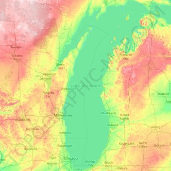
Name: Lake Michigan topographic map, elevation, terrain.
Location: Lake Michigan, United States (41.60887 -88.04169 46.10229 -84.75193)
Average elevation: 260 m
Minimum elevation: 169 m
Maximum elevation: 582 m
Lake Michigan is one of the five Great Lakes of North America. It is the second-largest of the Great Lakes by volume (1,180 cu mi (4,900 km3)) and the third-largest by surface area (22,404 sq mi (58,030 km2)), after Lake Superior and Lake Huron (and is slightly smaller than the U.S. state of West Virginia). To the east, its basin is conjoined with that of Lake Huron through the narrow Straits of Mackinac, giving it the same surface elevation as its easterly counterpart; the two are technically a single lake.
Other topographic maps
Click on a map to view its topography, its elevation and its terrain.
College Station
United States > Texas > Brazos County
College Station, Brazos County, Texas, United States
Average elevation: 87 m
Houston
United States > Texas > Harris County
Houston, Harris County, Texas, United States
Average elevation: 25 m
Los Angeles
Los Angeles, Los Angeles County, California, United States
Average elevation: 241 m
New Orleans
United States > Louisiana > Orleans Parish
New Orleans, Orleans Parish, Louisiana, United States
Average elevation: 1 m
Jacksonville
United States > Florida > Duval County
Jacksonville, Duval County, Florida, United States
Average elevation: 10 m
Albuquerque
United States > New Mexico > Bernalillo County
Albuquerque, Bernalillo County, New Mexico, United States
Average elevation: 1,688 m
Sarasota
United States > Florida > Sarasota County
Sarasota, Sarasota County, Florida, United States
Average elevation: 7 m
Brooklyn
United States > New York > New York
Brooklyn, Kings County, New York, United States
Average elevation: 9 m
Riverside County
Riverside County, California, United States
Average elevation: 538 m
Sacramento
United States > California > Sacramento County
Sacramento, Sacramento County, California, United States
Average elevation: 10 m
Fairfax County
Fairfax County, Virginia, United States
Average elevation: 75 m
Spokane
United States > Washington > Spokane County
Spokane, Spokane County, Washington, United States
Average elevation: 655 m
Seattle
United States > Washington > King County
Seattle, King County, Washington, United States
Average elevation: 40 m
Fort Worth
United States > Texas > Tarrant County
Fort Worth, Tarrant County, Texas, United States
Average elevation: 212 m
Cochise County
Cochise County, Arizona, United States
Average elevation: 1,410 m
Clark County
Clark County, Washington, United States
Average elevation: 266 m
Carmel
United States > Indiana > Hamilton County
Carmel, Hamilton County, Indiana, United States
Average elevation: 253 m
Hudson River
Hudson River, New Jersey, 12834:12871, United States
Average elevation: 297 m