
Oregon topographic map
Interactive map
Click on the map to display elevation.
About this map
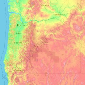
Name: Oregon topographic map, elevation, terrain.
Location: Oregon, United States (41.99179 -124.70354 46.29257 -116.46315)
Average elevation: 938 m
Minimum elevation: -3 m
Maximum elevation: 4,170 m
The earliest evidence of the name Oregon has Spanish origins. The term "orejón" (meaning "big ear") comes from the historical chronicle Relación de la Alta y Baja California (1598), written by Rodrigo Montezuma of New Spain; it made reference to the Columbia River when the Spanish explorers penetrated into the North American territory that became part of the Viceroyalty of New Spain. This chronicle is the first topographical and linguistic source with respect to the place name Oregon. Another possible source is the Spanish word oregano, which refers to a plant that grows in the southern part of the region. It is also possible that the American territory was named by the Spaniards, as there is a stream in Spain called the "Arroyo del Oregón" (which is located in the province of Ciudad Real), or that the "j" in the Spanish phrase "El Orejón" was later corrupted into a "g", and in context might refer to the 'earful' of the massive Columbia River at its mouth.
Other topographic maps
Click on a map to view its topography, its elevation and its terrain.
Cochise County
Cochise County, Arizona, United States
Average elevation: 1,410 m
Los Angeles
Los Angeles, Los Angeles County, California, United States
Average elevation: 241 m
Appalachian Mountains
United States > North Carolina > Yancey County
Appalachian Mountains, Yancey County, North Carolina, United States
Average elevation: 1,463 m
Indianapolis
United States > Indiana > Indianapolis
Indianapolis, Marion County, Indiana, 46204, United States
Average elevation: 241 m
Houston
United States > Texas > Harris County
Houston, Harris County, Texas, United States
Average elevation: 25 m
Des Moines
United States > Iowa > Polk County
Des Moines, Polk County, Iowa, United States
Average elevation: 264 m
New Orleans
United States > Louisiana > Orleans Parish
New Orleans, Orleans Parish, Louisiana, United States
Average elevation: 1 m
Brooklyn
United States > New York > New York
Brooklyn, Kings County, New York, United States
Average elevation: 9 m
New Haven
United States > Connecticut > New Haven County > New Haven
New Haven, New Haven County, Connecticut, United States
Average elevation: 22 m
Santa Cruz
United States > California > Santa Cruz County
Santa Cruz, Santa Cruz County, California, United States
Average elevation: 89 m
Sarasota
United States > Florida > Sarasota County
Sarasota, Sarasota County, Florida, United States
Average elevation: 7 m
Lancaster County
Lancaster County, Pennsylvania, United States
Average elevation: 158 m
Grand Teton National Park
United States > Wyoming > Teton County
Grand Teton National Park, Teton County, Wyoming, United States
Average elevation: 2,409 m
Charlotte County
Charlotte County, Florida, United States
Average elevation: 10 m
Olympic National Park
Olympic National Park, Washington, United States
Average elevation: 412 m
Corpus Christi
United States > Texas > Nueces County
Corpus Christi, Nueces County, Texas, United States
Average elevation: 8 m