
Missouri River topographic map
Interactive map
Click on the map to display elevation.
About this map
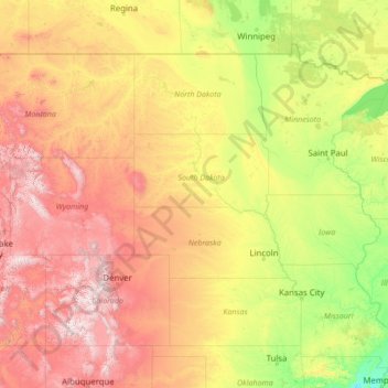
Name: Missouri River topographic map, elevation, terrain.
Location: Missouri River, 59248, United States (38.53487 -112.01534 48.14971 -90.11771)
Average elevation: 901 m
Minimum elevation: 60 m
Maximum elevation: 4,096 m
Elevations in the watershed vary widely, ranging from just over 400 feet (120 m) at the Missouri's mouth to the 14,293-foot (4,357 m) summit of Mount Lincoln in central Colorado. The river drops 8,626 feet (2,629 m) from Brower's Spring, the farthest source. Although the plains of the watershed have extremely little local vertical relief, the land rises about 10 feet per mile (1.9 m/km) from east to west. The elevation is less than 500 feet (150 m) at the eastern border of the watershed, but is over 3,000 feet (910 m) above sea level in many places at the base of the Rockies.
Other topographic maps
Click on a map to view its topography, its elevation and its terrain.
College Station
United States > Texas > Brazos County
College Station, Brazos County, Texas, United States
Average elevation: 87 m
Houston
United States > Texas > Harris County
Houston, Harris County, Texas, United States
Average elevation: 25 m
Los Angeles
Los Angeles, Los Angeles County, California, United States
Average elevation: 241 m
New Orleans
United States > Louisiana > Orleans Parish
New Orleans, Orleans Parish, Louisiana, United States
Average elevation: 1 m
Jacksonville
United States > Florida > Duval County
Jacksonville, Duval County, Florida, United States
Average elevation: 10 m
Albuquerque
United States > New Mexico > Bernalillo County
Albuquerque, Bernalillo County, New Mexico, United States
Average elevation: 1,688 m
Sarasota
United States > Florida > Sarasota County
Sarasota, Sarasota County, Florida, United States
Average elevation: 7 m
Brooklyn
United States > New York > New York
Brooklyn, Kings County, New York, United States
Average elevation: 9 m
Riverside County
Riverside County, California, United States
Average elevation: 538 m
Sacramento
United States > California > Sacramento County
Sacramento, Sacramento County, California, United States
Average elevation: 10 m
Fairfax County
Fairfax County, Virginia, United States
Average elevation: 75 m
Spokane
United States > Washington > Spokane County
Spokane, Spokane County, Washington, United States
Average elevation: 655 m
Seattle
United States > Washington > King County
Seattle, King County, Washington, United States
Average elevation: 40 m
Fort Worth
United States > Texas > Tarrant County
Fort Worth, Tarrant County, Texas, United States
Average elevation: 212 m
Cochise County
Cochise County, Arizona, United States
Average elevation: 1,410 m
Clark County
Clark County, Washington, United States
Average elevation: 266 m
Carmel
United States > Indiana > Hamilton County
Carmel, Hamilton County, Indiana, United States
Average elevation: 253 m
Hudson River
Hudson River, New Jersey, 12834:12871, United States
Average elevation: 297 m