
Maryland topographic map
Interactive map
Click on the map to display elevation.
About this map
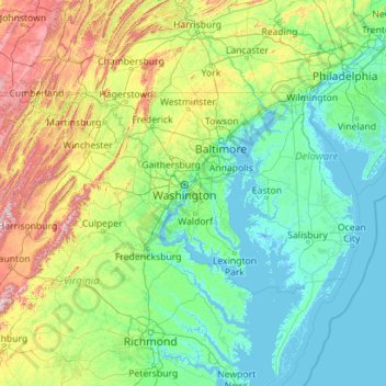
Name: Maryland topographic map, elevation, terrain.
Location: Maryland, United States (37.88653 -79.48731 39.72288 -74.98520)
Average elevation: 149 m
Minimum elevation: -4 m
Maximum elevation: 1,218 m
Sixteen of Maryland's twenty-three counties, as well as the city of Baltimore, border the tidal waters of the Chesapeake Bay estuary and its many tributaries, which combined total more than 4,000 miles of shoreline. Although one of the smallest states in the U.S., it features a variety of climates and topographical features that have earned it the moniker of America in Miniature. In a similar vein, Maryland's geography, culture, and history combine elements of the Mid-Atlantic, Northeastern, and Southern regions of the country.
Other topographic maps
Click on a map to view its topography, its elevation and its terrain.
Los Angeles
Los Angeles, Los Angeles County, California, United States
Average elevation: 241 m
Houston
United States > Texas > Harris County
Houston, Harris County, Texas, United States
Average elevation: 25 m
Brooklyn
United States > New York > New York
Brooklyn, Kings County, New York, United States
Average elevation: 9 m
Fort Worth
United States > Texas > Tarrant County
Fort Worth, Tarrant County, Texas, United States
Average elevation: 212 m
Sacramento
United States > California > Sacramento County
Sacramento, Sacramento County, California, United States
Average elevation: 10 m
Cochise County
Cochise County, Arizona, United States
Average elevation: 1,410 m
College Station
United States > Texas > Brazos County
College Station, Brazos County, Texas, United States
Average elevation: 87 m
Albuquerque
United States > New Mexico > Bernalillo County
Albuquerque, Bernalillo County, New Mexico, United States
Average elevation: 1,688 m
Des Moines
United States > Iowa > Polk County
Des Moines, Polk County, Iowa, United States
Average elevation: 264 m
Pensacola
United States > Florida > Escambia County
Pensacola, Escambia County, Florida, United States
Average elevation: 21 m
City of Albany
United States > New York > Albany County
City of Albany, Albany County, New York, United States
Average elevation: 68 m
Missoula
United States > Montana > Missoula County
Missoula, Missoula County, Montana, United States
Average elevation: 1,173 m
New Orleans
United States > Louisiana > Orleans Parish
New Orleans, Orleans Parish, Louisiana, United States
Average elevation: 1 m
Eau Claire County
Eau Claire County, Wisconsin, United States
Average elevation: 304 m
Lexington
United States > Kentucky > Lexington
Lexington, Fayette County, Kentucky, 40508, United States
Average elevation: 285 m
Jacksonville
United States > Florida > Duval County
Jacksonville, Duval County, Florida, United States
Average elevation: 10 m
Steamboat Springs
United States > Colorado > Routt County
Steamboat Springs, Routt County, Colorado, United States
Average elevation: 2,228 m
Bronx County
United States > New York > New York
Bronx County, The Bronx, New York, United States
Average elevation: 21 m