
Make a donation
Gear up for your next adventure:
As an Amazon Associate, this site earns from qualifying purchases at no extra cost to you.
Delta topographic map
Click on the map to display elevation.
Make a donation
Gear up for your next adventure:
As an Amazon Associate, this site earns from qualifying purchases at no extra cost to you.
About this map
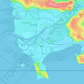
Name: Delta topographic map, elevation, terrain.
Average elevation: 13 m
Minimum elevation: -4 m
Maximum elevation: 154 m
Make a donation
Gear up for your next adventure:
As an Amazon Associate, this site earns from qualifying purchases at no extra cost to you.
Other topographic maps
Click on a map to view its topography, its elevation and its terrain.
Burnaby
Canada > British Columbia > Metro Vancouver Regional District > Burnaby
Burnaby occupies 98.60 square kilometres (38.07 sq mi) and is located at the geographic centre of the Metro Vancouver area and home to the Metro Vancouver regional government in Metrotown. Situated between the city of Vancouver on the west and Port Moody, Coquitlam, and New Westminster on the east, Burnaby is…
Average elevation: 144 m
Stanley Park
Canada > British Columbia > Metro Vancouver Regional District > Vancouver
Average elevation: 14 m
Little Mountain
Canada > British Columbia > Metro Vancouver Regional District > Vancouver
Little Mountain, elevation 125 m (410 ft), is a mountain in the central part of the city of Vancouver, British Columbia, Canada. The mountain is home to Queen Elizabeth Park, which sits at the top of the mountain, and Nat Bailey Stadium, which is located near the base. The mountain lends its name to the Riley…
Average elevation: 81 m
Make a donation
Gear up for your next adventure:
As an Amazon Associate, this site earns from qualifying purchases at no extra cost to you.
Mount Seymour
Canada > British Columbia > Metro Vancouver Regional District > District of North Vancouver
Average elevation: 1,030 m
Woodlot 0007
Canada > British Columbia > Metro Vancouver Regional District > Maple Ridge
Average elevation: 322 m
Walnut Park
Canada > British Columbia > Metro Vancouver Regional District > Surrey
Average elevation: 49 m
Annacis Island
Canada > British Columbia > Metro Vancouver Regional District > Delta
Average elevation: 16 m
Make a donation
Gear up for your next adventure:
As an Amazon Associate, this site earns from qualifying purchases at no extra cost to you.
Town Centre Park
Canada > British Columbia > Metro Vancouver Regional District > Coquitlam
Average elevation: 62 m
Finn Slough
Canada > British Columbia > Metro Vancouver Regional District > Richmond
Average elevation: 2 m
Grouse Mountain
Canada > British Columbia > Metro Vancouver Regional District
Grouse Mountain is one of the North Shore Mountains of the Pacific Ranges in the District Municipality of North Vancouver, British Columbia, Canada. With a maximum elevation of over 1,200 m (4,100 feet) at its peak, the mountain is the site of an alpine ski area, Grouse Mountain Resort, which overlooks Greater…
Average elevation: 968 m
Alouette Lake
Canada > British Columbia > Metro Vancouver Regional District > Maple Ridge
Average elevation: 549 m
Make a donation
Gear up for your next adventure:
As an Amazon Associate, this site earns from qualifying purchases at no extra cost to you.
Burnaby Mountain
Canada > British Columbia > Metro Vancouver Regional District > Burnaby
Due to its relatively high elevation, snow will often fall on the higher levels of Burnaby Mountain while rain falls in the surrounding cities. Tobogganing is a popular pastime at Centennial Park on winter days with snow.
Average elevation: 167 m
Whonnock Lake
Canada > British Columbia > Metro Vancouver Regional District > Maple Ridge
Average elevation: 190 m
Cliff Falls
Canada > British Columbia > Metro Vancouver Regional District > Maple Ridge
Average elevation: 106 m
Make a donation
Gear up for your next adventure:
As an Amazon Associate, this site earns from qualifying purchases at no extra cost to you.
Ocean Rocks Viewpoint
Canada > British Columbia > Metro Vancouver Regional District > Bowen Island Municipality
Average elevation: 33 m
Blue Mountain Park
Canada > British Columbia > Metro Vancouver Regional District > Coquitlam
Average elevation: 119 m
Livingstone Lake
Canada > British Columbia > Metro Vancouver Regional District > Vancouver
Average elevation: 86 m
Yew Lake
Canada > British Columbia > Metro Vancouver Regional District > West Vancouver
Average elevation: 990 m
Make a donation
Gear up for your next adventure:
As an Amazon Associate, this site earns from qualifying purchases at no extra cost to you.
Jericho Beach
Canada > British Columbia > Metro Vancouver Regional District > Vancouver
Average elevation: 20 m
Morgan Heights
Canada > British Columbia > Metro Vancouver Regional District > Surrey
Average elevation: 61 m
Langley Township
Canada > British Columbia > Metro Vancouver Regional District > Township of Langley > Langley Township
Average elevation: 37 m
Barnes Lake
Canada > British Columbia > Metro Vancouver Regional District > Electoral Area A
Average elevation: 1,277 m
Make a donation
Gear up for your next adventure:
As an Amazon Associate, this site earns from qualifying purchases at no extra cost to you.
Wreck Beach
Canada > British Columbia > Metro Vancouver Regional District > Electoral Area A
Average elevation: 32 m
Trout Lake
Canada > British Columbia > Metro Vancouver Regional District > Vancouver
Average elevation: 52 m
White Pine Beach
Canada > British Columbia > Metro Vancouver Regional District > Port Moody
Average elevation: 125 m
Make a donation
Gear up for your next adventure:
As an Amazon Associate, this site earns from qualifying purchases at no extra cost to you.
Central Park
Canada > British Columbia > Metro Vancouver Regional District > Burnaby
Average elevation: 113 m
Crystal Falls
Canada > British Columbia > Metro Vancouver Regional District > Coquitlam
Average elevation: 221 m
Queen Elizabeth Park
Canada > British Columbia > Metro Vancouver Regional District > Vancouver
Average elevation: 81 m
Make a donation
Gear up for your next adventure:
As an Amazon Associate, this site earns from qualifying purchases at no extra cost to you.
Pitt Meadows
Canada > British Columbia > Metro Vancouver Regional District > Pitt Meadows > Pitt Meadows
Average elevation: 7 m
Richmond
Canada > British Columbia > Metro Vancouver Regional District > Richmond
Average elevation: 15 m
Langley City
Canada > British Columbia > Metro Vancouver Regional District > Langley City
Average elevation: 57 m
Strathcona Park
Canada > British Columbia > Metro Vancouver Regional District > Vancouver
Average elevation: 17 m
Make a donation
Gear up for your next adventure:
As an Amazon Associate, this site earns from qualifying purchases at no extra cost to you.
Port Coquitlam
Canada > British Columbia > Metro Vancouver Regional District > Port Coquitlam
Average elevation: 185 m
Port Moody
Canada > British Columbia > Metro Vancouver Regional District > Port Moody
Average elevation: 233 m
Coquitlam
Canada > British Columbia > Metro Vancouver Regional District > Coquitlam
Southwest Coquitlam comprises the original core of the city, with Maillardville and Fraser River industrial sector giving way to the large residential areas of Austin Heights, colloquially referred to as "The Bump" due to its high and flat plateau topography. These older residences, with larger property…
Average elevation: 230 m
White Rock
Canada > British Columbia > Metro Vancouver Regional District > White Rock > White Rock
Average elevation: 38 m
Make a donation
Gear up for your next adventure:
As an Amazon Associate, this site earns from qualifying purchases at no extra cost to you.
Still Creek
Canada > British Columbia > Metro Vancouver Regional District > Vancouver
Average elevation: 65 m
English Bay Beach
Canada > British Columbia > Metro Vancouver Regional District > Vancouver
Average elevation: 12 m
Tynehead Regional Park
Canada > British Columbia > Metro Vancouver Regional District > Surrey
Average elevation: 45 m
Slocan Park
Canada > British Columbia > Metro Vancouver Regional District > Vancouver
Average elevation: 81 m
Make a donation
Gear up for your next adventure:
As an Amazon Associate, this site earns from qualifying purchases at no extra cost to you.
Mundy Park
Canada > British Columbia > Metro Vancouver Regional District > Coquitlam
Average elevation: 139 m
Fraser River (North Arm)
Canada > British Columbia > Metro Vancouver Regional District > Richmond
Average elevation: 27 m
Ketcheson Neighbourhood Park
Canada > British Columbia > Metro Vancouver Regional District > Richmond
Average elevation: 3 m
Passage Island
Canada > British Columbia > Metro Vancouver Regional District > Electoral Area A
Average elevation: 0 m
Make a donation
Gear up for your next adventure:
As an Amazon Associate, this site earns from qualifying purchases at no extra cost to you.
Fraser River Park
Canada > British Columbia > Metro Vancouver Regional District > Vancouver
Average elevation: 19 m
Westburnco Dog Park
Canada > British Columbia > Metro Vancouver Regional District > New Westminster
Average elevation: 68 m
Mount Eldee
Canada > British Columbia > Metro Vancouver Regional District > Electoral Area A
Average elevation: 1,026 m
Make a donation
Gear up for your next adventure:
As an Amazon Associate, this site earns from qualifying purchases at no extra cost to you.
Andy Livingstone Park
Canada > British Columbia > Metro Vancouver Regional District > Vancouver
Average elevation: 12 m
Mosquito Creek Park
Canada > British Columbia > Metro Vancouver Regional District
Average elevation: 214 m
Riverway Sports Complex
Canada > British Columbia > Metro Vancouver Regional District > Burnaby
Average elevation: 42 m
Make a donation
Gear up for your next adventure:
As an Amazon Associate, this site earns from qualifying purchases at no extra cost to you.
Crescent Beach
Canada > British Columbia > Metro Vancouver Regional District > Surrey
Average elevation: 22 m
Newton Athletic Park
Canada > British Columbia > Metro Vancouver Regional District > Surrey
Average elevation: 86 m
Kensington Park
Canada > British Columbia > Metro Vancouver Regional District > Vancouver
Average elevation: 81 m
Westminster Pier Park
Canada > British Columbia > Metro Vancouver Regional District > New Westminster
Average elevation: 27 m
Make a donation
Gear up for your next adventure:
As an Amazon Associate, this site earns from qualifying purchases at no extra cost to you.
Seymour River
Canada > British Columbia > Metro Vancouver Regional District > Electoral Area A
Average elevation: 490 m
Essondale Islet
Canada > British Columbia > Metro Vancouver Regional District > Port Coquitlam
Average elevation: 12 m
Green Timbers Urban Forest
Canada > British Columbia > Metro Vancouver Regional District > Surrey
Average elevation: 100 m
Make a donation
Gear up for your next adventure:
As an Amazon Associate, this site earns from qualifying purchases at no extra cost to you.
Burnaby Lake Regional Park
Canada > British Columbia > Metro Vancouver Regional District > Burnaby
Average elevation: 51 m
Mitchell Island
Canada > British Columbia > Metro Vancouver Regional District > Richmond
Average elevation: 14 m
North Peak
Canada > British Columbia > Metro Vancouver Regional District > Bowen Island Municipality
Average elevation: 331 m
Panorama Park Off-Leash Area
Canada > British Columbia > Metro Vancouver Regional District > Surrey
Average elevation: 76 m
Make a donation
Gear up for your next adventure:
As an Amazon Associate, this site earns from qualifying purchases at no extra cost to you.
Stoney Creek Park
Canada > British Columbia > Metro Vancouver Regional District > Burnaby
Average elevation: 85 m
Sheffield Park
Canada > British Columbia > Metro Vancouver Regional District > Coquitlam
Average elevation: 153 m
Burke Mountain Pioneer Park
Canada > British Columbia > Metro Vancouver Regional District > Coquitlam
Average elevation: 129 m
Mike Lake
Canada > British Columbia > Metro Vancouver Regional District > Maple Ridge
Average elevation: 297 m
Make a donation
Gear up for your next adventure:
As an Amazon Associate, this site earns from qualifying purchases at no extra cost to you.
South Aldergrove Park
Canada > British Columbia > Metro Vancouver Regional District > Township of Langley
Average elevation: 104 m
Cambie Park
Canada > British Columbia > Metro Vancouver Regional District > Vancouver
Average elevation: 61 m
Ioco
Canada > British Columbia > Metro Vancouver Regional District > Port Moody
Average elevation: 97 m
Make a donation
Gear up for your next adventure:
As an Amazon Associate, this site earns from qualifying purchases at no extra cost to you.
Charleson Park
Canada > British Columbia > Metro Vancouver Regional District > Vancouver
Average elevation: 28 m
Gaston Park
Canada > British Columbia > Metro Vancouver Regional District > Vancouver
Average elevation: 104 m
Brewers Park
Canada > British Columbia > Metro Vancouver Regional District > Vancouver
Average elevation: 64 m
Point Grey Park Site at Trutch Street
Canada > British Columbia > Metro Vancouver Regional District > Vancouver
Average elevation: 15 m
Make a donation
Gear up for your next adventure:
As an Amazon Associate, this site earns from qualifying purchases at no extra cost to you.
Aldergrove Regional Park
Canada > British Columbia > Metro Vancouver Regional District > Township of Langley
Average elevation: 64 m
Barnston Island
Canada > British Columbia > Metro Vancouver Regional District > Electoral Area A
Average elevation: 6 m
Maple Ridge Park
Canada > British Columbia > Metro Vancouver Regional District > Maple Ridge
Average elevation: 41 m
Barnet Marine Park
Canada > British Columbia > Metro Vancouver Regional District > Burnaby
Average elevation: 95 m
Make a donation
Gear up for your next adventure:
As an Amazon Associate, this site earns from qualifying purchases at no extra cost to you.
Waterfront Park
Canada > British Columbia > Metro Vancouver Regional District > North Vancouver
Average elevation: 22 m
Cottonwood Park
Canada > British Columbia > Metro Vancouver Regional District > Surrey
Average elevation: 37 m
McBride Park
Canada > British Columbia > Metro Vancouver Regional District > Vancouver
Average elevation: 22 m
Burns Point
Canada > British Columbia > Metro Vancouver Regional District > Port Moody
Average elevation: 94 m
Make a donation
Gear up for your next adventure:
As an Amazon Associate, this site earns from qualifying purchases at no extra cost to you.
Burnaby Mountain
Canada > British Columbia > Metro Vancouver Regional District > Burnaby
Due to its relatively high elevation, snow will often fall on the higher levels of Burnaby Mountain while rain falls in the surrounding cities. Tobogganing is a popular pastime at Centennial Park on winter days with snow.
Average elevation: 167 m
Tynehead Regional Park
Canada > British Columbia > Metro Vancouver Regional District > Surrey
Average elevation: 45 m
Make a donation
Gear up for your next adventure:
As an Amazon Associate, this site earns from qualifying purchases at no extra cost to you.
Poplar Island
Canada > British Columbia > Metro Vancouver Regional District > New Westminster
Average elevation: 32 m
Barge Park
Canada > British Columbia > Metro Vancouver Regional District > White Rock
Average elevation: 53 m
Queen Elizabeth Park
Canada > British Columbia > Metro Vancouver Regional District > Vancouver
Average elevation: 81 m
Annacis Island
Canada > British Columbia > Metro Vancouver Regional District > Delta
Average elevation: 16 m
Make a donation
Gear up for your next adventure:
As an Amazon Associate, this site earns from qualifying purchases at no extra cost to you.
Queen Elizabeth Park
Canada > British Columbia > Metro Vancouver Regional District > Vancouver
Average elevation: 81 m
Cougar Creek Park
Canada > British Columbia > Metro Vancouver Regional District > Surrey
Average elevation: 86 m
Black Mountain (North Summit)
Canada > British Columbia > Metro Vancouver Regional District > West Vancouver
Average elevation: 931 m
Make a donation
Gear up for your next adventure:
As an Amazon Associate, this site earns from qualifying purchases at no extra cost to you.