
South Dakota topographic map
Interactive map
Click on the map to display elevation.
About this map
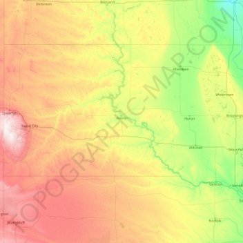
Name: South Dakota topographic map, elevation, terrain.
Location: South Dakota, United States (42.47989 -104.05776 45.94545 -96.43634)
Average elevation: 717 m
Minimum elevation: 274 m
Maximum elevation: 2,166 m
Black Elk Peak, formerly named Harney Peak, with an elevation of 7,242 ft (2,207 m), is the state's highest point, while the shoreline of Big Stone Lake is the lowest, with an elevation of 966 ft (294 m). South Dakota is bordered to the north by North Dakota; to the south by Nebraska; to the east by Iowa and Minnesota; and to the west by Wyoming and Montana. The geographical center of the U.S. is 17 miles (27 km) west of Castle Rock in Butte County. The North American continental pole of inaccessibility is between Allen and Kyle, 1,024 mi (1,648 km) from the nearest coastline.
Other topographic maps
Click on a map to view its topography, its elevation and its terrain.
Albuquerque
United States > New Mexico > Bernalillo County
Albuquerque, Bernalillo County, New Mexico, United States
Average elevation: 1,688 m
Brooklyn
United States > New York > New York
Brooklyn, Kings County, New York, United States
Average elevation: 9 m
Appalachian Mountains
United States > North Carolina > Yancey County
Appalachian Mountains, Yancey County, North Carolina, United States
Average elevation: 1,463 m
Houston
United States > Texas > Harris County
Houston, Harris County, Texas, United States
Average elevation: 25 m
Santa Cruz
United States > California > Santa Cruz County
Santa Cruz, Santa Cruz County, California, United States
Average elevation: 89 m
Bronx County
United States > New York > New York
Bronx County, The Bronx, New York, United States
Average elevation: 21 m
Brunswick County
United States > North Carolina
Brunswick County, North Carolina, United States
Average elevation: 9 m
New Orleans
United States > Louisiana > Orleans Parish
New Orleans, Orleans Parish, Louisiana, United States
Average elevation: 1 m
Manhattan
United States > New York > New York County > New York
Manhattan, New York County, New York, United States
Average elevation: 16 m
Boulder
United States > Colorado > Boulder County
Boulder, Boulder County, Colorado, United States
Average elevation: 1,785 m
Central Park
United States > New York > New York County > New York
Central Park, New York County, New York, United States
Average elevation: 26 m
Des Moines
United States > Iowa > Polk County
Des Moines, Polk County, Iowa, United States
Average elevation: 264 m
Boston
United States > Massachusetts > Suffolk County
Boston, Suffolk County, Massachusetts, United States
Average elevation: 25 m
Rudyard
United States > Michigan > Chippewa County
Rudyard, Rudyard Township, Chippewa County, Michigan, United States
Average elevation: 209 m
Jacksonville
United States > Florida > Duval County
Jacksonville, Duval County, Florida, United States
Average elevation: 10 m
Yakima County
Yakima County, Washington, United States
Average elevation: 879 m
Moab
United States > Utah > Grand County
Moab, Grand County, Utah, 84532, United States
Average elevation: 1,357 m
Palm Springs
United States > California > Riverside County
Palm Springs, Riverside County, California, United States
Average elevation: 859 m