
United Kingdom topographic map
Interactive map
Click on the map to display elevation.
About this map
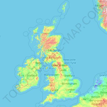
Name: United Kingdom topographic map, elevation, terrain.
Location: United Kingdom (49.67400 -14.01552 61.06100 2.09191)
Average elevation: 42 m
Minimum elevation: -6 m
Maximum elevation: 1,617 m
Scotland accounts for just under one-third (32 per cent) of the total area of the UK, covering 78,772 square kilometres (30,410 sq mi). This includes nearly 800 islands, predominantly west and north of the mainland; notably the Hebrides, Orkney Islands and Shetland Islands. Scotland is the most mountainous country in the UK and its topography is distinguished by the Highland Boundary Fault – a geological rock fracture – which traverses Scotland from Arran in the west to Stonehaven in the east. The fault separates two distinctively different regions; namely the Highlands to the north and west and the Lowlands to the south and east. The more rugged Highland region contains the majority of Scotland's mountainous land, including Ben Nevis which at 1,345 metres (4,413 ft) is the highest point in the British Isles. Lowland areas – especially the narrow waist of land between the Firth of Clyde and the Firth of Forth known as the Central Belt – are flatter and home to most of the population including Glasgow, Scotland's largest city, and Edinburgh, its capital and political centre, although upland and mountainous terrain lies within the Southern Uplands.
Other topographic maps
Click on a map to view its topography, its elevation and its terrain.
The World
United Arab Emirates > Dubai > Dubai
The World, Dubai, United Arab Emirates
Average elevation: 0 m
Ukraine
Ukraine
Average elevation: 183 m
Europe
Europe
Average elevation: 223 m
London
United Kingdom > England > London
London, Greater London, England, SW1A 2DX, United Kingdom
Average elevation: 42 m
United States
United States
Average elevation: 309 m
Indonesia
Indonesia
Average elevation: 81 m
Sweden
Sweden
Average elevation: 163 m
Italy
Italy
Average elevation: 293 m
India
India
Average elevation: 1,017 m
Australia
Australia
Average elevation: 35 m
Romania
Romania
Average elevation: 355 m
Japan
Japan
Average elevation: 58 m
Poland
Poland
Average elevation: 194 m
Germany
Germany
Average elevation: 237 m
Greece
Greece
Average elevation: 170 m
Chennai
India > Tamil Nadu > Chennai
Chennai, Chennai District, Tamil Nadu, India
Average elevation: 8 m
Turkey
Turkey
Average elevation: 487 m
Egypt
Egypt
Average elevation: 272 m
Africa
Africa
Average elevation: 462 m
France
France
Average elevation: 430 m
Netherlands
Netherlands
Average elevation: 251 m
Spain
Spain
Average elevation: 331 m
Bengaluru
India > Karnataka > Bangalore North
Bengaluru, Bangalore North, Bengaluru Urban District, Karnataka, India
Average elevation: 881 m
Israel
Israel
Average elevation: 410 m
Finland
Finland
Average elevation: 201 m
Belgium
Belgium
Average elevation: 138 m
North America
North America
Average elevation: 294 m
Mexico
Mexico
Average elevation: 412 m
Portugal
Portugal
Average elevation: 268 m
Asia
Asia
Average elevation: 563 m