
Blue Nile topographic map
Interactive map
Click on the map to display elevation.
Blue Nile
Although there are several feeder streams that flow into Lake Tana, the sacred source of the river is generally considered to be a small spring at Gish Abay, situated at an elevation of approximately 2,744 metres (9,003 ft). This stream, known as the Gilgel Abay (Lesser Abay River), flows north into Lake Tana. Other affluents of this lake include, in clockwise order from Gorgora, the Magech River, the Northern Gumara, the Reb River, the southern Gumara River, and the Kilte. Lake Tana's outflow then flows some 30 kilometres (19 mi) before plunging over the Blue Nile Falls. The river then loops across northwest Ethiopia through a series of deep valleys and canyons into Sudan, by which point it is only known as the Blue Nile.
About this map
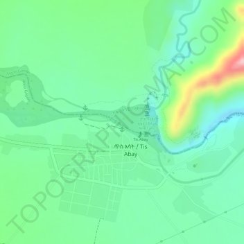
Name: Blue Nile topographic map, elevation, terrain.
Location: Blue Nile, South Gonder, Amhara Region, Ethiopia (11.48813 37.58253 11.49020 37.58613)
Average elevation: 1,647 m
Minimum elevation: 1,591 m
Maximum elevation: 1,768 m
Other topographic maps
Click on a map to view its topography, its elevation and its terrain.
Addis Ababa
Ethiopia > Addis Ababa > Arada
Moreover, the city held strong social organizations pattern prior Italian invasion. According to Richard Pankhurst (1968), the city accelerated population growth due to factors of provisional governors and their troops, the 1892 famine, eventually the Battle of Adwa. Another include the 1907 land act,…
Average elevation: 2,517 m
Adama
Ethiopia > Oromia Region > Adama
Adama (Oromo: Adaamaa or Hadaamaa), the city officially known as Adama formerly known as Nazret (ናዝሬት), is a city in central Oromia. Adama forms a Special Zone of Oromia and is surrounded by East shewa Zone. It is located at 8°32′N 39°16′E / 8.54°N 39.27°E / 8.54; 39.27 at an elevation…
Average elevation: 1,673 m
Bale Mountains National Park
The Bale Mountains play a vital role in climate control of the region by attracting large amounts of orographic rainfall, which has obvious implications for livestock and agricultural production. Some 600–1,000 mm (24–39 in) fall annually in the lower altitude areas, while 1,000–1,400 mm (39–55 in)…
Average elevation: 2,612 m
Goba
Goba (Oromo: Gobbaa, Amharic: ጎባ) is a town and separate woreda located in the Bale Zone of the Oromia Region, Ethiopia approximately 446 km southeast of Addis Ababa, this city has a latitude and longitude of 7°0′N 39°59′E / 7.000°N 39.983°E / 7.000; 39.983 and an elevation of 2,743 meters above sea level.
Average elevation: 2,736 m
Holeta Genet
Ethiopia > Oromia Region > Walmara
Holeta (Oromo: Holataa) is a town in the special zone of Oromia Region, Ethiopia. It has a latitude and longitude of 9°3′N 38°30′E / 9.050°N 38.500°E / 9.050; 38.500 and an altitude of 2391 meters above sea level.
Average elevation: 2,391 m
Kamisee
Kemise (Oromo: Kamisee; Amharic: ከሚሴ) is a town and administrative seat of the Oromia Zone in the Amhara Region, Ethiopia. Kemise is 224 kilometres (139 mi) northeast of the Ethiopian capital, Addis Ababa and has a latitude and longitude of 10°43′N 39°52′E / 10.717°N 39.867°E / 10.717;…
Average elevation: 1,494 m
Debre Birhan
Debre Birhan (Amharic: ደብረ ብርሃን) is a city in central Ethiopia. Located in the Semien Shewa Zone of Amhara Region, about 120 kilometers north east of Addis Ababa on Ethiopian highway 2, the town has an elevation of 2,840 meters, which makes it the highest town in Africa. It was an early capital…
Average elevation: 2,720 m
Sawla
Ethiopia > South Ethiopia Regional State
Sawla (also known as Felege Neway) is a town in southern Ethiopia. Located in Gofa Zone of the Southern Nations, Nationalities and Peoples' Region, this town has a latitude and longitude of 6°18′N 36°53′E / 6.300°N 36.883°E / 6.300; 36.883 with an elevation of 1,395 metres (4,577 ft) above sea…
Average elevation: 1,485 m
Bechena
Bichena (Amharic: ብቸና) is a town in northern Ethiopia. Located in the Misraq Gojjam Zone of the Amhara Region on the hillside overlooking the Abay River, it has a latitude and longitude of 10°27′N 38°12′E / 10.450°N 38.200°E / 10.450; 38.200 and an elevation of 2541 meters above sea…
Average elevation: 2,461 m
Sokoru
The altitude of this woreda ranges from 1160 to 2940 meters above sea level; the highest points include Ali Shashema, Ali Derar and Kumbi. Perennial rivers include the Gilgel Gibe a tributary of the Gibe, and the Kawar; seasonal streams include the Melka Luku. A survey of the land in this woreda shows that…
Average elevation: 1,827 m
Bahir Dar Special Zone
Bahir Dar is located at the exit of the Abbay from Lake Tana at an altitude of 1,820 metres (5,970 ft) above sea level. The city is located approximately 578 km north-northwest of Addis Ababa. The Lake Tana region is a UNESCO Biosphere Reserve since 2015.
Average elevation: 1,794 m
Tepi
Tepi (also transliterated Teppi and Tippi) is a town in southern Ethiopia. The vowels in the name are pronounced as in the English words tape and pea. Located in the Sheka Zone of the South West Ethiopia Region, this town has a latitude and longitude of 7°12′N 35°27′E / 7.200°N 35.450°E /…
Average elevation: 1,207 m
Gambela Region
The Anywaa Zone is by far the largest of the zones of Gambela region and also includes the capital, Gambela. The terrain is mostly flat at elevations between 400 – 550 meters above sea level but with the eastern fringes of Anywaa Zone and in particular the easternmost zone, Majang, being partly in the…
Average elevation: 652 m
Debre Tabor
Debre Tabor (Amharic: ደብረ ታቦር, lit. "Mount Tabor") is a town and woreda in north-central Ethiopia. Located in the Debub Gondar Zone of the Amhara Region, about 100 kilometers southeast of Gondar and 50 kilometers east of Lake Tana, this historic town has a latitude and longitude of 11°51′N…
Average elevation: 2,565 m
Lake Langano
Lake Langano (Oromo: Hora Langaanoo, Amharic: ላንጋኖ ሐይቅ) is a lake in the Oromia Region of Ethiopia, exactly 200 kilometers by road south of the capital, Addis Ababa, on the border between the East Shewa Zone and Arsi Zones. It is located to the east of Lake Abijatta in the Main Ethiopian Rift at…
Average elevation: 1,625 m
Dessie
Dessie (Amharic: ደሴ, romanized: Däse; also spelled Dese or Dessye) is a town in north-central Ethiopia. Located in the South Wollo Zone of the Amhara Region, it sits at a latitude and longitude of 11°8′N 39°38′E / 11.133°N 39.633°E / 11.133; 39.633, with an elevation between 2,470 and…
Average elevation: 2,450 m
Mieso
Mieso (Oromo: Mi'eesso) is a town in eastern Ethiopia. Located in the West Hararghe Zone of the Oromia Region, it has a latitude and longitude of 9°14′N 40°45′E / 9.233°N 40.750°E / 9.233; 40.750 with an elevation of 1394 meters above sea level.
Average elevation: 1,369 m
Bati
Bati (Oromo: Baati; Amharic: ባቲ) is a town in north-central Ethiopia. Located in the Oromia Zone of the Amhara Region, east of Dessie this town has a latitude and longitude of 11°11′N 40°1′E / 11.183°N 40.017°E / 11.183; 40.017 with an elevation of 1502 metres above sea level. It is the…
Average elevation: 1,450 m
Sheraro
Sheraro (Tigrinya: ሸራሮ) is a town and separate woreda in Tigray, Ethiopia. It is located in the North Western Zone of the Tigray Region, at an elevation of 1246 meters above sea level. It is the administrative center of Tahtay Adiyabo. It is near the border with Eritrea.
Average elevation: 1,041 m
Gebre Guracha Medhane `Alem Bete Kristiyan
Ethiopia > Oromia Region > Gebre Guracha
Average elevation: 2,473 m