
Malaysia topographic map
Interactive map
Click on the map to display elevation.
Malaysia
The two parts of Malaysia, separated from each other by the South China Sea, share a largely similar landscape in that both Peninsular and East Malaysia feature coastal plains rising to hills and mountains. Peninsular Malaysia, containing 40 per cent of Malaysia's land area, extends 740 km (460 mi) from north to south, and its maximum width is 322 km (200 mi). It is divided between its east and west coasts by the Titiwangsa Mountains, rising to a peak elevation of 2,183 metres (7,162 ft) at Mount Korbu, part of a series of mountain ranges running down the centre of the peninsula. These mountains are heavily forested, and mainly composed of granite and other igneous rocks. Much of it has been eroded, creating a karst landscape. The range is the origin of some of Peninsular Malaysia's river systems. The coastal plains surrounding the peninsula reach a maximum width of 50 kilometres (31 mi), and the peninsula's coastline is nearly 1,931 km (1,200 mi) long, although harbours are only available on the western side.
About this map
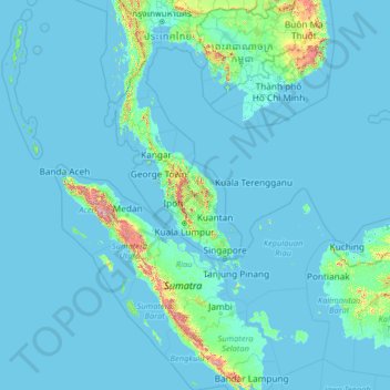
Name: Malaysia topographic map, elevation, terrain.
Location: Malaysia (0.85382 98.73651 8.38015 119.46996)
Average elevation: 54 m
Minimum elevation: -3 m
Maximum elevation: 3,191 m
Other topographic maps
Click on a map to view its topography, its elevation and its terrain.
Europe
Europe's topography is characterized by a striking contrast between its rugged southern mountains and the expansive plains of the north. The continent is often described as a "peninsula of peninsulas," featuring major peninsulas like the Iberian, Italian, and Balkan, each with unique geological features. In…
Average elevation: 223 m
Africa
Africa's topography is a complex tapestry of plateaus, mountains, valleys, and deserts. The continent is dominated by vast plateaus, with elevations averaging around 1,000 meters (3,281 feet), especially prominent in the south and east. The Ethiopian Highlands, often referred to as the "Roof of Africa," rise…
Average elevation: 462 m
Karachi
Pakistan > Sindh > Karachi South District > Saddar Town
Karachi lies very close to a major fault line, where the Indian tectonic plate meets the Arabian tectonic plate. Within the city of Karachi are two small ranges: the Khasa Hills and Mulri Hills, which lie in the northwest and act as a barrier between North Nazimabad and Orangi. Karachi's hills are barren and…
Average elevation: 20 m
Istanbul
Istanbul, located in northwestern Turkey, is a city that is uniquely situated across two continents, Europe and Asia, divided by the Bosphorus Strait. The city’s topography is characterized by a complex blend of hills, valleys, and coastal plains, which create a varied and scenic landscape. The European side…
Average elevation: 57 m
Pittsburgh
United States of America > Pennsylvania > Pittsburgh
The warmest month of the year in Pittsburgh is July, with a 24-hour average of 72.6 °F (22.6 °C). Conditions are often humid, and combined with highs reaching 90 °F (32 °C) on an average 9.5 days a year, a considerable heat index arises. The coolest month is January, when the 24-hour average is 28.4 °F…
Average elevation: 315 m
Appalachian Mountains
United States > North Carolina > Yancey County
The Appalachian Mountains (French: Appalaches), often called the Appalachians, are a system of mountains in eastern to northeastern North America. The Appalachians first formed roughly 480 million years ago during the Ordovician Period. They once reached elevations similar to those of the Alps and the Rocky…
Average elevation: 1,463 m
Estes Park
United States > Colorado > Larimer County
Estes Park sits at an elevation of 7,522 feet (2,293 m) on the front range of the Rocky Mountains at the eastern entrance of the Rocky Mountain National Park. Its north, south and east extremities border the Roosevelt National Forest. Lumpy Ridge lies immediately north of Estes Park.
Average elevation: 2,543 m
Virginia Beach
United States > Virginia > Virginia Beach
According to the United States Census Bureau, the city has a total area of 497 square miles (1,290 km2), of which 249 square miles (640 km2) is land and 248 square miles (640 km2) (49.9%) is water. It is the largest city in Virginia by total area and third-largest city land area. The average elevation is 12…
Average elevation: 2 m
Edinburgh
United Kingdom > Scotland > Edinburgh
Some have called Edinburgh the Athens of the North for a variety of reasons. The earliest comparison between the two cities showed that they had a similar topography, with the Castle Rock of Edinburgh performing a similar role to the Athenian Acropolis. Both of them had flatter, fertile agricultural land…
Average elevation: 104 m
Baltimore
United States > Maryland > Baltimore
Baltimore is in north-central Maryland on the Patapsco River close to where it empties into the Chesapeake Bay. The city is also located on the fall line between the Piedmont Plateau and the Atlantic coastal plain, which divides Baltimore into "lower city" and "upper city". The city's elevation ranges from sea…
Average elevation: 65 m
South America
The east-central Brazilian plateau has a humid and warm tropical climate. The northern and eastern parts of the Argentine pampas have a humid subtropical climate with dry winters and humid summers of the Chinese type, while the western and eastern ranges have a subtropical climate of the dinaric type. At the…
Average elevation: 283 m
Islamabad
Pakistan > Islamabad Capital Territory
Islamabad is located at 33°26′N 73°02′E / 33.43°N 73.04°E / 33.43; 73.04 at the northern edge of the Pothohar Plateau and at the foot of the Margalla Hills in Islamabad Capital Territory. Its elevation is 540 metres (1,770 ft). The modern capital and the ancient Gakhar city of Rawalpindi form…
Average elevation: 666 m
Adelaide
Australia > South Australia > Adelaide
South Australia was officially established as a British Province in England in February 1836. The first Governor proclaimed the commencement of colonial government in South Australia on 28 December 1836, near The Old Gum Tree in what is now the suburb of Glenelg North. The event is commemorated in South…
Average elevation: 148 m
Penang Island
Penang Island is irregularly shaped, with a hilly and mostly forested interior; its coastal plains are narrow, the most extensive of which is at the northeastern cape. With a height of 833 m (2,733 ft), Penang Hill, at the centre of the island, is the tallest point within Penang. From a small settlement at the…
Average elevation: 117 m
North America
North America's topography is characterized by its diverse and dramatic landscapes, stretching from the towering Rocky Mountains in the west to the expansive Great Plains in the central region, and the rugged Appalachian Mountains in the east. The Rocky Mountains, which include peaks exceeding 20,000 feet…
Average elevation: 294 m
Aberdeen
United Kingdom > Scotland > Aberdeen
Two weather stations collect climate data for the area, Aberdeen/Dyce Airport, and Craibstone. Both are about 4 1⁄2 miles (7 km) to the north west of the city centre, and given that they are in close proximity to each other, exhibit very similar climatic regimes. Dyce tends to have marginally warmer daytime…
Average elevation: 52 m
Sochi
Russia > Krasnodar Krai > Resort Town of Sochi (municipal formation)
Sochi has a humid subtropical climate (Köppen climate classification Cfa), at the lower elevations. Its average annual temperature is 18.9 °C (66.0 °F) during the day and 11.5 °C (52.7 °F) at night. In the coldest months—January and February—the average temperature is about 10 °C (50 °F) during the…
Average elevation: 148 m
Hamburg
The neighborhoods of Neuenfelde, Cranz, Francop and Finkenwerder are part of the Altes Land (old land) region, the largest contiguous fruit-producing region in Central Europe. Neugraben-Fischbek has Hamburg's highest elevation, the Hasselbrack at 116.2 metres (381 ft) AMSL. Hamburg borders the states of…
Average elevation: 23 m
Scottsdale
United States > Arizona > Maricopa County > Scottsdale
The city is in the Salt River Valley, or the "Valley of the Sun," in the northern reaches of the Sonoran Desert. Scottsdale, 31 mi (50 km) long and 11.4 mi (18.3 km) wide at its widest point, shares boundaries with many other municipalities and entities. On the west, Scottsdale is bordered by Phoenix, Paradise…
Average elevation: 414 m
Crescent City
United States > California > Del Norte County
The topography of the sea floor surrounding Crescent City has the effect of focusing tsunamis. According to researchers at Humboldt State University and the University of Southern California, the city experienced tsunami conditions 31 times between the years 1933 and 2008. Although many of these incidents were…
Average elevation: 31 m
Indianapolis
United States > Indiana > Indianapolis
Indianapolis is within the Tipton Till Plain, a flat to gently sloping terrain underlain by glacial deposits known as till. The lowest point in the city is about 650 feet (198 m) above mean sea level, with the highest natural elevation at about 900 feet (274 m) above sea level. Few hills or short ridges, known…
Average elevation: 241 m
Addis Ababa
Ethiopia > Addis Ababa > Arada
Moreover, the city held strong social organizations pattern prior Italian invasion. According to Richard Pankhurst (1968), the city accelerated population growth due to factors of provisional governors and their troops, the 1892 famine, eventually the Battle of Adwa. Another include the 1907 land act,…
Average elevation: 2,517 m
Mexico City
Mexico is crossed from north to south by two mountain ranges known as Sierra Madre Oriental and Sierra Madre Occidental, which are the extension of the Rocky Mountains from northern North America. From east to west at the center, the country is crossed by the Trans-Mexican Volcanic Belt also known as the…
Average elevation: 2,321 m
Highlands
United States > North Carolina > Macon County > Highlands
Highlands was founded in 1875 after its two founders, Samuel Truman Kelsey and Clinton Carter Hutchinson, drew lines from Chicago to Savannah and from New Orleans to New York City. They felt that the place where these lines met would eventually become a great trading center and commercial crossroads. Highlands…
Average elevation: 1,090 m
Glasgow
United Kingdom > Scotland > Glasgow City
Glasgow itself was reputed to have been founded by the Christian missionary Saint Mungo in the 6th century. He established a church on the Molendinar Burn, where the present Glasgow Cathedral stands, and in the following years Glasgow became a religious centre. Glasgow grew over the following centuries. The…
Average elevation: 128 m
Kuala Lumpur
Located in the centre of Selangor state, Kuala Lumpur was a territory of Selangor State Government. In 1974, Kuala Lumpur was split off from Selangor to form the first Federal Territory governed directly by the Malaysian federal government. Its location in the most developed state on the west coast of…
Average elevation: 127 m
United Kingdom
Scotland accounts for just under a third (32 per cent) of the total area of the UK, covering 78,772 square kilometres (30,410 sq mi). This includes nearly eight hundred islands, predominantly west and north of the mainland; notably the Hebrides, Orkney Islands and Shetland Islands. Scotland is the most…
Average elevation: 79 m
British Isles
The oldest rocks are 2.7 billion years old and are found in Ireland, Wales and the northwest of Scotland. During the Silurian period, the north-western regions collided with the south-east, which had been part of a separate continental landmass. The topography of the islands is modest in scale by global…
Average elevation: 25 m
Caucasus Mountains
Georgia > Mtskheta-Mtianeti > Dusheti Municipality > Chalisopeli
The climate of the Caucasus varies both vertically (according to elevation) and horizontally (by latitude and location). Temperature generally decreases as elevation rises. Average annual temperature in Sukhumi, Abkhazia at sea level is 15 °C (59 °F) while on the slopes of Mt.Kazbek at an elevation of 3,700…
Average elevation: 2,188 m
Asia
Average elevation: 563 m
Mt. Fuji
Japan > Sunto County > Oyama
Mount Fuji (富士山, Fujisan, Japanese: [ɸɯꜜ(d)ʑisaɴ] (listen)), or Fugaku, located on the island of Honshū, is the highest mountain in Japan, with a summit elevation of 3,776.24 m (12,389 ft 3 in). It is the second-highest volcano located on an island in Asia (after Mount Kerinci on the island of…
Average elevation: 3,261 m
Amman
Jordan > Amman > Amman Sub-District
Amman is situated on the East Bank Plateau, an upland characterized by three major wadis which run through it. Originally, the city had been built on seven hills. Amman's terrain is typified by its mountains. The most important areas in the city are named after the hills or mountains they lie on. The area's…
Average elevation: 800 m
Johannesburg
South Africa > Gauteng > City of Johannesburg Metropolitan Municipality
Johannesburg is located in the eastern plateau area of South Africa known as the Highveld, at an elevation of 1,753 metres (5,751 ft). The former Central Business District is located on the southern side of the prominent ridge called the Witwatersrand (English: White Water's Ridge) and the terrain falls to the…
Average elevation: 1,615 m
Swansea
United Kingdom > Wales > Swansea
Much of Swansea is hilly with the main area of upland being located in the council ward of Mawr. Areas up to 185 metres (607 ft) in elevation range across the central section: Kilvey Hill, Townhill and Llwynmawr separate the centre of Swansea from its northern suburbs. Cefn Bryn, a ridge of high land, is the…
Average elevation: 73 m
Cambridge
United Kingdom > England > Cambridge
The city, like most of the UK, has a maritime climate highly influenced by the Gulf Stream. Located in the driest region of Britain, Cambridge's rainfall averages around 570 mm (22.44 in) per year, around half the national average, with some years occasionally falling into the semi-arid (under 500 mm (19.69…
Average elevation: 18 m
Hineteawa / Bowen Falls
New Zealand > Southland > Southland District > Fiordland Community
Average elevation: 232 m
Cherryville
Canada > British Columbia > Regional District of North Okanagan > Area E (Cherryville/East Creighton)
Average elevation: 643 m
San Diego
United States > California > San Diego County > San Diego
The climate in San Diego, like most of Southern California, often varies significantly over short geographical distances, resulting in microclimates. In San Diego, this is mostly because of the city's topography (the Bay, and the numerous hills, mountains, and canyons). Frequently, particularly during the "May…
Average elevation: 57 m
Gilgit
Pakistan > Gilgit-Baltistan > Gilgit District
Gilgit lacks significant rainfall, averaging in 120 to 240 mm (4.7 to 9.4 in) annually, as monsoon breaks against the southern range of Himalayas. Irrigation for land cultivation is obtained from the rivers, abundant with melting snow water from higher altitudes.
Average elevation: 3,002 m
Himalayas
Nepal > Koshi Province > Solukhumbu
The Himalayas, or Himalaya (/ˌhɪməˈleɪ.ə, hɪˈmɑːləjə/; Sanskrit: [ɦɪmaːlɐjɐ]; from Sanskrit himá 'snow, frost', and ā-laya 'dwelling, abode'), is a mountain range in Asia, separating the plains of the Indian subcontinent from the Tibetan Plateau. The range has some of the planet's highest…
Average elevation: 7,555 m
Western Ghats
The range starts near south of the Tapti river and runs approximately 1,600 km (990 mi) through the states of Gujarat, Maharashtra, Karnataka, Goa, Kerala and Tamil Nadu ending at Marunthuvazh Malai, Swamithope near the southern tip of India. These hills cover 160,000 km2 (62,000 sq mi) and form the catchment…
Average elevation: 2,225 m
Bogota
The city is located in the center of Colombia, on a high plateau known as the Bogotá savanna, part of the Altiplano Cundiboyacense located in the Eastern Cordillera of the Andes. Its altitude averages 2,640 meters (8,660 ft) above sea level. Subdivided into 20 localities, Bogotá has an area of 1,587 square…
Average elevation: 2,735 m
Vijayawada
Vijayawada lies on the banks of Krishna river, covered by hills and canals. and at an altitude of 11 m (36 ft) above sea level. Three canals originating from the north side of the Prakasam Barrage reservoir — Eluru, Bandar, and Ryves — flow through the city.
Average elevation: 37 m
Quito
Quito (Spanish pronunciation: [ˈkito] (listen); Quechua: Kitu), formally San Francisco de Quito, is the capital and most populous city of Ecuador, with an estimated population of 2.8 million in its urban area. It is also the capital of the province of Pichincha. Quito is located in a valley on the eastern…
Average elevation: 2,930 m