
Ruse topographic map
Interactive map
Click on the map to display elevation.
About this map
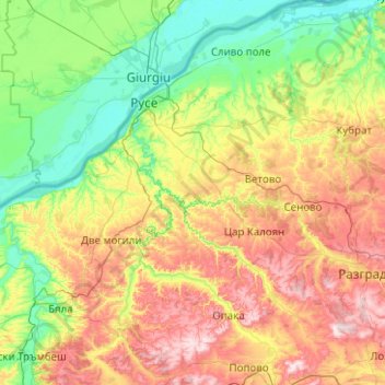
Name: Ruse topographic map, elevation, terrain.
Location: Ruse, Bulgaria (43.31717 25.45762 44.03745 26.45947)
Average elevation: 166 m
Minimum elevation: 12 m
Maximum elevation: 490 m
Other topographic maps
Click on a map to view its topography, its elevation and its terrain.
Vihren
Vihren (Bulgarian: Вихрен [ˈvixrɛn]) is the highest peak of Bulgaria's Pirin Mountains. Reaching 2,914 metres (9,560 ft), it is Bulgaria's second and the Balkans' third highest, after Musala and Mount Olympus. Although Vihren is deprived of lakes and streams due to the karst topography, a number of…
Average elevation: 2,442 m
Dobrinishte
Dobrinishte (Bulgarian: Добринище [dobˈriniʃtɛ]) is a small town and ski resort in the Blagoevgrad Province, Bansko Municipality, southwestern Bulgaria. As of 2006 it had 2973 inhabitants. It is located 6 km east of Bansko, a famous winter resort. It has an altitude of 850 m and is surrounded by…
Average elevation: 988 m
Belmeken
Belmeken (Bulgarian: Белмекен) is a summit in the northeastern part of the Rila Mountain in southwestern Bulgaria with a height of 2,626 m. It is built up of granite. Its northern slopes are steep and rise over the Kutlinite cirque. The southern and southeastern slopes are oblique. To the southeast at…
Average elevation: 2,300 m
Pasarel
Bulgaria > Sofia-City > Dolni Pasarel
The Pasarel dam and reservoir is located 20 km to the southeast of Sofia, Bulgaria at an altitude of 700 m.
Average elevation: 822 m
Laki
In 1889, Stefan Verkovic (Topographical and Ethnographic Essay of Macedonia) noted Lika (Laki) as a village with 63 Bulgarian and 18 Turkish houses.
Average elevation: 805 m
Bansko
Bansko (Bulgarian: Банско [ˈbansko]) is a town in southwestern Bulgaria, located at the foot of the Pirin Mountains at an elevation of 1200m above sea level. It is a ski resort.
Average elevation: 1,034 m
Vitosha
Due to a great variability in elevation, a rich diversity of climates, flora and fauna can be found within the park. Research has revealed that on the comparatively small area of the mountain there are 1,500 species of higher plants, 500 species of fungi, 500 species of algae, 326 species of mosses, and 200…
Average elevation: 2,105 m
Rhodope Mountains
In geomorphological terms, the Rhodopes are part of the Rila-Rhodope massif, which is the oldest landmass on the Balkan peninsula. The Rhodopes are spread over 14,735 square kilometers (5,689 sq mi), of which 12,233 square kilometers (4,723 sq mi) are on Bulgarian territory. They have the greatest extent of…
Average elevation: 501 m
Tuhovishta
Tuhovishta Village is located in the southwestern Rhodope Mountains and is part of the historical and geographical area Chech. t is located about 2 kilometers from the border with Greece. Altitude of the village is 700–999 meters and the area of the land is 17.15 km2. The village adjoins the lands of the…
Average elevation: 765 m
Borovets
Borovets (Bulgarian: Боровец [ˈbɔrovɛt͡s]), known as Chamkoria (Чамкория [ˈt͡ʃam koˈrijɐ]) until the middle of the 20th century, is a popular Bulgarian mountain resort situated in Sofia Province, on the northern slopes of Rila mountain, at an elevation of 1350 m.
Average elevation: 1,394 m