
Greater Accra Region topographic map
Interactive map
Click on the map to display elevation.
About this map
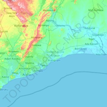
Name: Greater Accra Region topographic map, elevation, terrain.
Location: Greater Accra Region, Ghana (5.47065 -0.51970 6.10761 0.67226)
Average elevation: 62 m
Minimum elevation: -5 m
Maximum elevation: 665 m
Other topographic maps
Click on a map to view its topography, its elevation and its terrain.
Aburi
Ghana > Eastern Region > Akuapim South District
Due to the altitude of Aburi, the climate is a lot cooler than neighbouring Accra. The road which climbs the hillside to Aburi is a toll road, with the current toll being 0.50 Ghc for a car, 1.00 Ghc for a 4x4.
Average elevation: 277 m
Essaman
Ghana > Central Region > Komenda/Edina/Eguafo/Abirem Municipal District
Average elevation: 23 m
Lapaz
Ghana > Greater Accra Region > Okaikwei North Municipal District > Accra
Average elevation: 40 m
Oyarifa
Ghana > Greater Accra Region > La-Nkwantanang-Madina Municipal District
Average elevation: 108 m
Aburi
Ghana > Eastern Region > Akuapim South District
Due to the altitude of Aburi, the climate is a lot cooler than neighbouring Accra. The road which climbs the hillside to Aburi is a toll road, with the current toll being 0.50 Ghc for a car, 1.00 Ghc for a 4x4.
Average elevation: 277 m
Sekondi-Takoradi
Ghana > Western Region > Sekondi Takoradi Metropolitan District
Average elevation: 19 m
Dzorwulu
Ghana > Greater Accra Region > Ayawaso West Municipal District > Accra
Average elevation: 46 m
Komenda
Ghana > Central Region > Komenda/Edina/Eguafo/Abirem Municipal District
Average elevation: 5 m
Bibiani
Ghana > Western North Region > Bibiani Anhwiaso Bekwai Municipal District
Average elevation: 237 m
Agogo
Ghana > Ashanti Region > Asante-Akim North District
Agogo is located at 6.80004 (latitude in decimal degrees), -1.08193 (longitude in decimal degrees) at an elevation/altitude of 396 meters. The average elevation of Agogo in Asante Akim North Municipal is 396 meters.
Average elevation: 408 m
fiapre soccer field
Ghana > Bono Region > Sunyani Municipal District > Sunyani
Average elevation: 291 m