
Lahaul and Spiti topographic map
Interactive map
Click on the map to display elevation.
Lahaul and Spiti
The two valleys are quite different in character. Spiti is more barren and difficult to cross, with an average elevation of the valley floor of 4,270 m (14,010 ft). It is enclosed between lofty ranges, with the Spiti river rushing out of a gorge in the southeast to meet the Sutlej River. It is a typical mountain desert area with an average annual rainfall of only 170 mm (6.7 in).
About this map
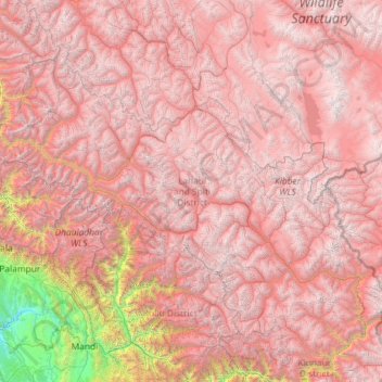
Name: Lahaul and Spiti topographic map, elevation, terrain.
Location: Lahaul and Spiti, Himachal Pradesh, India (31.74751 76.37292 33.25567 78.69266)
Average elevation: 4,281 m
Minimum elevation: 530 m
Maximum elevation: 6,629 m
Other topographic maps
Click on a map to view its topography, its elevation and its terrain.
Shikari Devi Wildlife Sanctuary
India > Himachal Pradesh > Thunag > Sangalwara
Average elevation: 2,518 m
Palampur
India > Himachal Pradesh > Palampur
Birni Devi Temple: Situated at an altitude of 2240 meters, offers a manageable day trek for visitors. Local residents along the route provide guidance through the forested path leading to the Birni top. The trek typically begins from Jakhani Mata temple, accessible by car, marking the starting point for the…
Average elevation: 1,764 m
Shimla
India > Himachal Pradesh > Shimla (urban)
Shimla is on the south-western ranges of the Himalayas at 31°37′N 77°06′E / 31.61°N 77.10°E / 31.61; 77.10. It has an average altitude of 2,206 metres (7,238 ft) above mean sea level and extends along a ridge with seven spurs. The city stretches nearly 9.2 kilometres (5.7 mi) from east to west.
Average elevation: 1,557 m
Darcha
India > Himachal Pradesh > Lahul
Darcha (elevation 3,360 m or 11,020 ft) is a pair of villages (Darcha Sumdo and Darach Dangma) on the Bhaga River in the Lahaul sub-division in the Lahaul and Spiti district in the Indian state of Himachal Pradesh. It is the northernmost permanent settlement in Himachal Pradesh along the Manali-Leh Highway.…
Average elevation: 3,702 m