
Namib topographic map
Interactive map
Click on the map to display elevation.
About this map
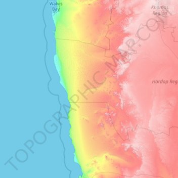
Name: Namib topographic map, elevation, terrain.
Location: Namib, Namibia (-26.70210 14.43302 -22.68153 16.45786)
Average elevation: 672 m
Minimum elevation: 0 m
Maximum elevation: 2,311 m
The Namib (/ˈnɑːmɪb/ NAH-mib; Portuguese: Namibe) is a coastal desert in Southern Africa. According to the broadest definition, the Namib stretches for more than 2,000 kilometres (1,200 mi) along the Atlantic coasts of Angola, Namibia, and South Africa, extending southward from the Carunjamba River in Angola, through Namibia and to the Olifants River in Western Cape, South Africa. The Namib's northernmost portion, which extends 450 kilometres (280 mi) from the Angola-Namibia border, is known as Moçâmedes Desert, while its southern portion approaches the neighboring Kalahari Desert. From the Atlantic coast eastward, the Namib gradually ascends in elevation, reaching up to 200 kilometres (120 mi) inland to the foot of the Great Escarpment. Annual precipitation ranges from 2 millimetres (0.079 in) in the aridest regions to 200 millimetres (7.9 in) at the escarpment, making the Namib the only true desert in southern Africa. Having endured arid or semi-arid conditions for roughly 55–80 million years, the Namib may be the oldest desert in the world and contains some of the world's driest regions, with only western South America's Atacama Desert to challenge it for age and aridity benchmarks.
Other topographic maps
Click on a map to view its topography, its elevation and its terrain.
Skeleton Coast Park
Skeleton Coast Park, Kunene Region, Namibia
Average elevation: 478 m
Fish River Canyon
Fish River Canyon, Fish River Canyon Hiking Trail, Karas, Namibia
Average elevation: 665 m
Helio (man-made water point)
Helio (man-made water point), Oshikoto, Namibia
Average elevation: 1,109 m
Damaraland
Namibia > Kunene Region > Vrede
Damaraland, C39, Vrede, Kunene Region, Namibia
Average elevation: 831 m
Katima Mulilo
Namibia > Zambezi > Katima Mulilo > Katima Mulilo
Katima Mulilo, Zambezi, 20001, Namibia
Average elevation: 968 m
Sesfontein
Namibia > Kunene Region > Sesfontein
Sesfontein, Kunene Region, Namibia
Average elevation: 608 m
Otjiwarongo
Namibia > Otjozondjupa > Otjiwarongo
Otjiwarongo, Otjozondjupa, 7151, Namibia
Average elevation: 1,471 m
Otjiwarongo
Otjiwarongo, Otjozondjupa, 12001, Namibia
Average elevation: 1,471 m
Kamanjab
Namibia > Kunene Region > Kamanjab
Kamanjab, Kunene Region, Namibia
Average elevation: 1,218 m
Gobabeb Research & Training
Namibia > Erongo Region > Gobabeb Research & Training
Gobabeb Research & Training, Erongo Region, Namibia
Average elevation: 410 m
Namib-Naukluft National Park
Namib-Naukluft National Park, Hardap, Namibia
Average elevation: 631 m