
Tafea topographic map
Interactive map
Click on the map to display elevation.
Tafea
The island of Tanna has the world's most accessible volcano, Mount Yasur, with 1,084 meters the highest peak of the province. Aniwa Island is the only coral island, the other four are volcanic and reach much higher elevations than Aniwa.
About this map
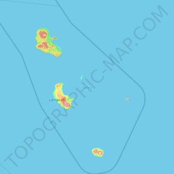
Name: Tafea topographic map, elevation, terrain.
Location: Tafea, Vanuatu (-20.46274 168.35376 -18.27167 170.44998)
Average elevation: 7 m
Minimum elevation: 0 m
Maximum elevation: 972 m
Other topographic maps
Click on a map to view its topography, its elevation and its terrain.
Pele
Vanuatu > Shefa Province > Pilliura
Pélé Island, sometimes spelled Pele in English, is a volcanic island located 11,2 miles north of the island of Éfaté in the Shefa Province of the Republic of Vanuatu. It has a total area of 1.7 square miles, Pélé is inhabited by about 200-220 Ni-Vanuatu villagers residing in the four villages: Worsiviu,…
Average elevation: 18 m
Tongariki Island
Vanuatu > Shefa Province > Port Vila
Tongariki is a small island of volcanic origin located in the eastern Shepherd Islands, having no beaches or reefs. Several small islands lie close to the south coast. The island is 3.8 km long and 1.7 km wide. The estimated terrain elevation above the sea level is some 20 metres. The uninhabited island of…
Average elevation: 49 m
Linua
Linua has a length of 2.8 km and diameter of 1 km. The estimated terrain elevation above sea level is 23 meters. Linua lies about 60 miles (100 km) north of Espiritu Santo Island between islands of Tegua and Lo. The island is surrounded by coral reefs. There is an airstrip on the island opened in 1983 that…
Average elevation: 5 m
Ambae
Traditional subsistence agriculture satisfies food needs, while most villagers engage in small-scale cash crop production as well. Often grown in large upland gardens (with good rainfall and safe from roving pigs), the primary crops are taro, banana, yam, and manioc. Kumala (sweet potatoes – a good tuber…
Average elevation: 175 m
Ambrym
While at higher elevations cinder cones predominate, the western tip of the island is characterized by a series of basaltic tuff rings, of which the largest is about 1 kilometre (0.62 mi) in diameter. These were produced by phreatic eruptions when magma contacted the water table and water-saturated sediments…
Average elevation: 121 m