
Rhode Island topographic map
Interactive map
Click on the map to display elevation.
About this map
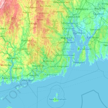
Name: Rhode Island topographic map, elevation, terrain.
Location: Rhode Island, United States (41.09583 -71.90743 42.01894 -71.08857)
Average elevation: 53 m
Minimum elevation: -8 m
Maximum elevation: 393 m
Rhode Island covers an area of 1,214 square miles (3,144 km2) within the New England region of the Northeastern United States and is bordered on the north and east by Massachusetts, on the west by Connecticut, and on the south by Rhode Island Sound and the Atlantic Ocean. It shares a narrow maritime border with New York State between Block Island and Long Island. The state's mean elevation is 200 feet (61 m). It is only 37 miles (60 km) wide and 48 miles (77 km) long, yet the state has a tidal shoreline on Narragansett Bay and the Atlantic Ocean of 384 miles (618 km).
Other topographic maps
Click on a map to view its topography, its elevation and its terrain.
Albuquerque
United States > New Mexico > Bernalillo County
Albuquerque, Bernalillo County, New Mexico, United States
Average elevation: 1,688 m
Sarasota
United States > Florida > Sarasota County
Sarasota, Sarasota County, Florida, United States
Average elevation: 7 m
Houston
United States > Texas > Harris County
Houston, Harris County, Texas, United States
Average elevation: 25 m
Seattle
United States > Washington > King County
Seattle, King County, Washington, United States
Average elevation: 40 m
Los Angeles
Los Angeles, Los Angeles County, California, United States
Average elevation: 241 m
Cedar Rapids
United States > Iowa > Linn County
Cedar Rapids, Linn County, Iowa, United States
Average elevation: 245 m
Carmel
United States > Indiana > Hamilton County
Carmel, Hamilton County, Indiana, United States
Average elevation: 253 m
Madison
United States > Wisconsin > Dane County
Madison, Dane County, Wisconsin, United States
Average elevation: 284 m
New Orleans
United States > Louisiana > Orleans Parish
New Orleans, Orleans Parish, Louisiana, United States
Average elevation: 1 m
Jacksonville
United States > Florida > Duval County
Jacksonville, Duval County, Florida, United States
Average elevation: 10 m
Brooklyn
United States > New York > New York
Brooklyn, Kings County, New York, United States
Average elevation: 9 m
Cochise County
Cochise County, Arizona, United States
Average elevation: 1,410 m
Guilford County
United States > North Carolina
Guilford County, North Carolina, United States
Average elevation: 239 m
Saint Johns County
Saint Johns County, Florida, United States
Average elevation: 6 m
Cape Cod
United States > Massachusetts > Plymouth County
Cape Cod, Plymouth County, Massachusetts, United States
Average elevation: 2 m
Spokane
United States > Washington > Spokane County
Spokane, Spokane County, Washington, United States
Average elevation: 655 m
New Haven
United States > Connecticut > New Haven County > New Haven
New Haven, New Haven County, Connecticut, United States
Average elevation: 22 m
Fullerton
United States > California > Orange County
Fullerton, Orange County, CAL Fire Southern Region, California, United States
Average elevation: 79 m
Boulder County
Boulder County, Colorado, United States
Average elevation: 2,308 m
Knoxville
United States > Tennessee > Knox County
Knoxville, Knox County, East Tennessee, Tennessee, United States
Average elevation: 307 m
Norfolk
United States > Virginia > Norfolk
Norfolk, Virginia, 23510, United States
Average elevation: 4 m
Boston
United States > Massachusetts > Suffolk County
Boston, Suffolk County, Massachusetts, United States
Average elevation: 25 m
Clackamas County
Clackamas County, Oregon, United States
Average elevation: 660 m