
Gear up for your next adventure:
As an Amazon Associate, this site earns from qualifying purchases at no extra cost to you.
Make a donation
Sadar topographic map
Click on the map to display elevation.
Gear up for your next adventure:
As an Amazon Associate, this site earns from qualifying purchases at no extra cost to you.
Gear up for your next adventure:
As an Amazon Associate, this site earns from qualifying purchases at no extra cost to you.
Make a donation
About this map
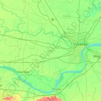
Name: Sadar topographic map, elevation, terrain.
Location: Sadar, Varanasi, Uttar Pradesh, India (25.16564 82.66944 25.44659 83.18517)
Average elevation: 81 m
Minimum elevation: 55 m
Maximum elevation: 166 m
Gear up for your next adventure:
As an Amazon Associate, this site earns from qualifying purchases at no extra cost to you.
Make a donation
Other topographic maps
Click on a map to view its topography, its elevation and its terrain.
Gear up for your next adventure:
As an Amazon Associate, this site earns from qualifying purchases at no extra cost to you.
Make a donation
Khurja
India > Uttar Pradesh > Khurja
Khurja is located at 28°15′N 77°51′E / 28.25°N 77.85°E / 28.25; 77.85. It has an average elevation of 197 metres (646 foot).
Average elevation: 198 m
Gear up for your next adventure:
As an Amazon Associate, this site earns from qualifying purchases at no extra cost to you.
Make a donation
Gear up for your next adventure:
As an Amazon Associate, this site earns from qualifying purchases at no extra cost to you.
Make a donation
Agra
India > Uttar Pradesh > Agra
The region around Agra consists almost entirely of a level plain, with hills in the extreme southwest. The rivers in the region include Yamuna and Chambal. The region is also watered by the Agra Canal. Millet, barley, wheat and cotton are among the crops grown in the surrounding countryside. Both Rabi and…
Average elevation: 166 m
Gear up for your next adventure:
As an Amazon Associate, this site earns from qualifying purchases at no extra cost to you.
Make a donation
Gear up for your next adventure:
As an Amazon Associate, this site earns from qualifying purchases at no extra cost to you.
Make a donation
Gear up for your next adventure:
As an Amazon Associate, this site earns from qualifying purchases at no extra cost to you.
Make a donation
Govardhan
India > Uttar Pradesh > Mathura District
Govardhana is located at 27°30′N 77°28′E / 27.5°N 77.47°E / 27.5; 77.47. It has an average elevation of 179 metres (587 feet). Govardhana has been made Tehsil in Mathura District by the Uttar Pradesh government.
Average elevation: 181 m
Gear up for your next adventure:
As an Amazon Associate, this site earns from qualifying purchases at no extra cost to you.
Make a donation
Baraut
India > Uttar Pradesh > Baraut
Baraut is located at 29.6°N 77.16°E, covering an area of 10.36 square kilometers (4.00 sq mi) and lying between the Ganga and Yamuna river plains. Its average elevation is 231 m (758 feet). Baraut is served by NH-709B and state highways SH-57 and SH-82.
Average elevation: 227 m
Gear up for your next adventure:
As an Amazon Associate, this site earns from qualifying purchases at no extra cost to you.
Make a donation
Gear up for your next adventure:
As an Amazon Associate, this site earns from qualifying purchases at no extra cost to you.
Make a donation
Gear up for your next adventure:
As an Amazon Associate, this site earns from qualifying purchases at no extra cost to you.
Make a donation
Gear up for your next adventure:
As an Amazon Associate, this site earns from qualifying purchases at no extra cost to you.
Make a donation
Robertsganj
India > Uttar Pradesh > Robertsganj
Robertsganj is located at 24°42′N 83°04′E / 24.7°N 83.07°E / 24.7; 83.07. It has an average elevation of 330 metres (1080 feet) from sea level. Robertsganj is located in the south-eastern ranges of the Vindhyachal mountain.
Average elevation: 313 m
Gear up for your next adventure:
As an Amazon Associate, this site earns from qualifying purchases at no extra cost to you.
Make a donation
Renukut
India > Uttar Pradesh > Dudhi > Renukut
Renukoot is located at 24°12′N 83°02′E / 24.2°N 83.03°E / 24.2; 83.03. It has an average elevation of 283 metres (931 feet). Renukoot lies in the southeast-most part of Uttar Pradesh and sits next to Shakti Nagar, Anpara, ((Dalla)) and Obra. Renukoot is in Sonebhadra district which is the only…
Average elevation: 285 m
Gear up for your next adventure:
As an Amazon Associate, this site earns from qualifying purchases at no extra cost to you.
Make a donation
Gear up for your next adventure:
As an Amazon Associate, this site earns from qualifying purchases at no extra cost to you.
Make a donation
Gear up for your next adventure:
As an Amazon Associate, this site earns from qualifying purchases at no extra cost to you.
Make a donation
Gear up for your next adventure:
As an Amazon Associate, this site earns from qualifying purchases at no extra cost to you.
Make a donation
Gear up for your next adventure:
As an Amazon Associate, this site earns from qualifying purchases at no extra cost to you.
Make a donation
Gear up for your next adventure:
As an Amazon Associate, this site earns from qualifying purchases at no extra cost to you.
Make a donation
Dibai
India > Uttar Pradesh > Debai
Dibai is located at 28°13′N 78°15′E / 28.22°N 78.25°E / 28.22; 78.25. It has an average elevation of 184 metres (603 feet).
Average elevation: 190 m
Gear up for your next adventure:
As an Amazon Associate, this site earns from qualifying purchases at no extra cost to you.
Make a donation
Gear up for your next adventure:
As an Amazon Associate, this site earns from qualifying purchases at no extra cost to you.
Make a donation