
Brazil topographic map
Interactive map
Click on the map to display elevation.
Brazil
Brazil's topography is diverse and characterized by a range of landforms, from vast lowlands to rugged plateaus and coastal ranges. The Amazon Basin, occupying over 60% of the country, is the largest drainage basin in the world, with flat, expansive terrain that receives immense rainfall, feeding the Amazon River. In contrast, the southeastern part of Brazil is dominated by the Brazilian Highlands, a region of ancient, eroded mountains and plateaus, where average elevations are around 3,300 feet (1,000 meters). The highest point in the country is Pico da Neblina, which rises to nearly 9,900 feet (3,014 meters) along the northern border. The country's coastal region features dramatic escarpments, with steep cliffs and tropical beaches along the Atlantic, while further inland, sedimentary basins and plains, such as the Pampas, provide fertile land for agriculture. This varied terrain shapes Brazil's ecosystems, from the tropical rainforests in the north to more temperate climates in the south.
About this map
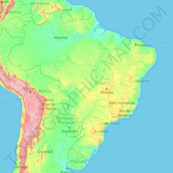
Name: Brazil topographic map, elevation, terrain.
Location: Brazil (-33.86943 -73.98306 5.26958 -28.62896)
Average elevation: 368 m
Minimum elevation: -2 m
Maximum elevation: 6,497 m
Other topographic maps
Click on a map to view its topography, its elevation and its terrain.
Europe
Europe's topography is characterized by a striking contrast between its rugged southern mountains and the expansive plains of the north. The continent is often described as a "peninsula of peninsulas," featuring major peninsulas like the Iberian, Italian, and Balkan, each with unique geological features. In…
Average elevation: 223 m
Istanbul
Istanbul, located in northwestern Turkey, is a city that is uniquely situated across two continents, Europe and Asia, divided by the Bosphorus Strait. The city’s topography is characterized by a complex blend of hills, valleys, and coastal plains, which create a varied and scenic landscape. The European side…
Average elevation: 57 m
Africa
Africa's topography is a complex tapestry of plateaus, mountains, valleys, and deserts. The continent is dominated by vast plateaus, with elevations averaging around 1,000 meters (3,281 feet), especially prominent in the south and east. The Ethiopian Highlands, often referred to as the "Roof of Africa," rise…
Average elevation: 462 m
North America
North America's topography is characterized by its diverse and dramatic landscapes, stretching from the towering Rocky Mountains in the west to the expansive Great Plains in the central region, and the rugged Appalachian Mountains in the east. The Rocky Mountains, which include peaks exceeding 20,000 feet…
Average elevation: 294 m
Asia
Average elevation: 563 m
South America
The east-central Brazilian plateau has a humid and warm tropical climate. The northern and eastern parts of the Argentine pampas have a humid subtropical climate with dry winters and humid summers of the Chinese type, while the western and eastern ranges have a subtropical climate of the dinaric type. At the…
Average elevation: 283 m
Glasgow
United Kingdom > Scotland > Glasgow City
Glasgow itself was reputed to have been founded by the Christian missionary Saint Mungo in the 6th century. He established a church on the Molendinar Burn, where the present Glasgow Cathedral stands, and in the following years Glasgow became a religious centre. Glasgow grew over the following centuries. The…
Average elevation: 128 m
Edinburgh
United Kingdom > Scotland > Edinburgh
Some have called Edinburgh the Athens of the North for a variety of reasons. The earliest comparison between the two cities showed that they had a similar topography, with the Castle Rock of Edinburgh performing a similar role to the Athenian Acropolis. Both of them had flatter, fertile agricultural land…
Average elevation: 104 m
Ho Chi Minh City
Ho Chi Minh City is located in the south-eastern region of Vietnam, 1,760 km (1,090 mi) south of Hanoi. The average elevation is 5 m (16 ft) above sea level for the city center and 16 m (52 ft) for the suburb areas. It borders Tây Ninh Province and Bình Dương Province to the north, Đồng Nai Province and…
Average elevation: 6 m
Dhaka
In 2013, suburban services to Narayanganj and Gazipur cities were upgraded using diesel electric multiple unit trains. The Dhaka Metro Rail feasibility study has been completed. A 20.1-kilometre (12.5 mi), $2.8-billion Phase 1 metro route is being negotiated by the Government with Japan International…
Average elevation: 7 m
Pittsburgh
United States of America > Pennsylvania > Pittsburgh
The warmest month of the year in Pittsburgh is July, with a 24-hour average of 72.6 °F (22.6 °C). Conditions are often humid, and combined with highs reaching 90 °F (32 °C) on an average 9.5 days a year, a considerable heat index arises. The coolest month is January, when the 24-hour average is 28.4 °F…
Average elevation: 315 m
Kuala Lumpur
Located in the centre of Selangor state, Kuala Lumpur was a territory of Selangor State Government. In 1974, Kuala Lumpur was split off from Selangor to form the first Federal Territory governed directly by the Malaysian federal government. Its location in the most developed state on the west coast of…
Average elevation: 127 m
Kolkata
Spread roughly north–south along the east bank of the Hooghly River, Kolkata sits within the lower Ganges Delta of eastern India approximately 75 km (47 mi) west of the international border with Bangladesh; the city's elevation is 1.5–9 m (5–30 ft). Much of the city was originally a wetland that was…
Average elevation: 5 m
Pahang
The highest peak, Mount Tahan, reaches 2,187 m (7,175 ft) in elevation, which is also the highest point in the Peninsular Malaysia. The climate is temperate enough to have distinct temperature variations year round, and much of the highlands are covered with tropical rainforest. Pahang is home to Malaysia's…
Average elevation: 90 m
Sibu
Sibu is located near the Rajang delta at the confluence of Rajang and Igan rivers. Peat swamp forests and alluvial plains are particularly prevalent in the Sibu Division. Sibu is located on a deep peat soil, which has caused problems in infrastructure development because buildings and roads slowly sink into…
Average elevation: 10 m
Cluj-Napoca
A wide variety of flora grow in the Cluj-Napoca Botanical Garden; some animals have also found refuge there. The city has a number of other parks, of which the largest is the Central Park. This park was founded during the 19th century and includes an artificial lake with an island, as well as the largest…
Average elevation: 490 m
Weston-super-Mare
United Kingdom > England > North Somerset > Weston-super-Mare
Average elevation: 13 m
Kilimanjaro
Mount Kilimanjaro (/ˌkɪlɪmənˈdʒɑːroʊ/) is a dormant volcano in Tanzania. It is the highest mountain in Africa and the highest free-standing mountain above sea level in the world: 5,895 m (19,341 ft) above sea level and 4,900 m (16,100 ft) above its plateau base. It is also the highest volcano in the…
Average elevation: 1,537 m
Appalachian Mountains
United States > North Carolina > Yancey County
The Appalachian Mountains (French: Appalaches), often called the Appalachians, are a system of mountains in eastern to northeastern North America. The Appalachians first formed roughly 480 million years ago during the Ordovician Period. They once reached elevations similar to those of the Alps and the Rocky…
Average elevation: 1,463 m
City of London
United Kingdom > England > City of London > City of London
The elevation of the City ranges from sea level at the Thames to 21.6 metres (71 ft) at the junction of High Holborn and Chancery Lane. Two small but notable hills are within the historic core, Ludgate Hill to the west and Cornhill to the east. Between them ran the Walbrook, one of the many "lost" rivers or…
Average elevation: 42 m
Mombasa
Being a coastal town, Mombasa is characterised by a flat topography. The town of Mombasa is centred on Mombasa Island, but extends to the mainland. The island is separated from the mainland by two creeks, Port Reitz in the south and Tudor Creek in the north.
Average elevation: 18 m
Plymouth
United Kingdom > England > Devon > Plymouth
The River Plym, which flows off Dartmoor to the north-east, forms a smaller estuary to the east of the city called Cattewater. Plymouth Sound is protected from the sea by the Plymouth Breakwater, in use since 1814. In the Sound is Drake's Island which is seen from Plymouth Hoe, a flat public area on top of…
Average elevation: 81 m
Shattuckville
United States > Michigan > Saginaw County > Saginaw Charter Township
Average elevation: 187 m
Abha
Abha is located in the southern region of Asir at an elevation of about 2,270 metres (7,450 feet) above sea level. Abha lies on the western edge of Mount Al-Hijaz, near Jabal Sawda, the highest peak in Saudi Arabia. Treating the Asir Mountains as part of the Sarawat, the landscape is otherwise dominated by the…
Average elevation: 1,994 m
Mount Everest
Nepal > Eastern Development Region > Qutang > Khumjung
Mount Everest (Chinese: 珠穆朗玛 Zhūmùlǎngmǎ; Nepali: सगरमाथा, romanized: Sagarmāthā; Tibetan: Chomolungma ཇོ་མོ་གླང་མ) is Earth's highest mountain above sea level, located in the Mahalangur Himal sub-range of the Himalayas. The China–Nepal border runs across its…
Average elevation: 7,841 m
Cuzco
Cusco is the seventh-most populous city in Peru; in 2017, it had a population of 428,450. It is also the largest city in the Peruvian Andes and the region is the seventh-most populous metropolitan area of Peru. Its elevation is around 3,400 m (11,200 ft). The largest district in the city is the Cusco District,…
Average elevation: 3,790 m
Cambridge
United Kingdom > England > Cambridge
The city, like most of the UK, has a maritime climate highly influenced by the Gulf Stream. Located in the driest region of Britain, Cambridge's rainfall averages around 570 mm (22.44 in) per year, around half the national average, with some years occasionally falling into the semi-arid (under 500 mm (19.69…
Average elevation: 18 m
Vicar Water Country Park
United Kingdom > England > Nottinghamshire > Newark and Sherwood > Clipstone
Average elevation: 97 m
San Diego
United States > California > San Diego County > San Diego
The climate in San Diego, like most of Southern California, often varies significantly over short geographical distances, resulting in microclimates. In San Diego, this is mostly because of the city's topography (the Bay, and the numerous hills, mountains, and canyons). Frequently, particularly during the "May…
Average elevation: 57 m
Antalya
While the city itself only has modest elevation changes, Antalya has high mountains in all directions to its interior. With moisture being trapped, the local climate thus has high winter rainfall, while the interior bay setting result in very hot summers for a coastal city.
Average elevation: 117 m
Medellín
Colombia > Antioquia > Medellín
Medellín has 16 comunas (districts), 5 corregimientos (townships), and 271 barrios (neighborhoods). The metropolitan area of Medellín lies within the Aburrá valley at an elevation of 1,500 metres (4,900 feet) above sea level and is bisected by the Medellín River (also called Porce), which flows northward.…
Average elevation: 2,098 m
Toronto
Despite its deep ravines, Toronto is not remarkably hilly, but its elevation does increase steadily away from the lake. Elevation differences range from 76.5 metres (251 ft) above sea level at the Lake Ontario shore to 209 m (686 ft) ASL near the York University grounds in the city's north end at the…
Average elevation: 113 m
Mexico City
Mexico is crossed from north to south by two mountain ranges known as Sierra Madre Oriental and Sierra Madre Occidental, which are the extension of the Rocky Mountains from northern North America. From east to west at the center, the country is crossed by the Trans-Mexican Volcanic Belt also known as the…
Average elevation: 2,321 m
Peterborough
United Kingdom > England > Cambridgeshire
The local topography is flat, and in some places, the land lies below sea level, for example in parts of the Fens to the east and to the south of Peterborough. Human settlement in the area began before the Bronze Age, as can be seen at the Flag Fen archaeological site to the east of the current city centre,…
Average elevation: 17 m
Chennai
Chennai is located on the south–eastern coast of India in the north–eastern part of Tamil Nadu on a flat coastal plain known as the Eastern Coastal Plains. Its average elevation is around 6.7 metres (22 ft), and its highest point is 60 m (200 ft). Chennai is 2,184 kilometres (1,357 mi) south of Delhi,…
Average elevation: 7 m
Santiago
Chile > Santiago Metropolitan Region > Provincia de Santiago > Santiago
The city lies in the center of the Santiago Basin, a large bowl-shaped valley consisting of broad and fertile lands surrounded by mountains. The city has a varying elevation, gradually increasing from 400 m (1,312 ft) in the western areas to more than 700 m (2,297 ft) in the eastern areas. Santiago's…
Average elevation: 724 m
Mount Everest
Nepal > Koshi Province > Solukhumbu
Mount Everest (Nepali: सगरमाथा, romanized: Sagarmāthā; Standard Tibetan: ཇོ་མོ་གླང་མ, romanized: Chomolungma; Chinese: 珠穆朗玛峰; pinyin: Zhūmùlǎngmǎ Fēng) is Earth's highest mountain above sea level, located in the Mahalangur Himal sub-range of the Himalayas.…
Average elevation: 7,847 m
Mecca
Saudi Arabia > Makkah Region > Makkah Al Mukarramah > Mecca
Mecca is at an elevation of 277 m (909 ft) above sea level, and approximately 80 km (50 mi) inland from the Red Sea. Central Mecca lies in a corridor between mountains, which is often called the "Hollow of Mecca". The area contains the valley of Al Taneem, the Valley of Bakkah and the valley of Abqar. This…
Average elevation: 313 m
Virginia Beach
United States > Virginia > Virginia Beach
According to the United States Census Bureau, the city has a total area of 497 square miles (1,290 km2), of which 249 square miles (640 km2) is land and 248 square miles (640 km2) (49.9%) is water. It is the largest city in Virginia by total area and third-largest city land area. The average elevation is 12…
Average elevation: 2 m
Karachi
Pakistan > Sindh > Karachi South District > Saddar Town
Karachi lies very close to a major fault line, where the Indian tectonic plate meets the Arabian tectonic plate. Within the city of Karachi are two small ranges: the Khasa Hills and Mulri Hills, which lie in the northwest and act as a barrier between North Nazimabad and Orangi. Karachi's hills are barren and…
Average elevation: 20 m
Mount Rushmore
United States > South Dakota > Pennington County
Mount Rushmore National Memorial is centered on a colossal sculpture carved into the granite face of Mount Rushmore (Lakota: Tȟuŋkášila Šákpe, or Six Grandfathers) in the Black Hills near Keystone, South Dakota. Sculptor Gutzon Borglum created the sculpture's design and oversaw the project's execution…
Average elevation: 1,562 m
Atlanta
United States > Georgia > Fulton County
Atlanta (/ætˈlæntə/ at-LAN-tə) is the capital and most populous city of the U.S. state of Georgia. It is the seat of Fulton County, the most populous county in Georgia. With a population of 498,715 living within the city limits, it is the eighth most populous city in the Southeast and 38th most populous…
Average elevation: 285 m
La Paz
Bolivia > La Paz > Pedro Domingo Murillo > La Paz
The city, in west-central Bolivia 68 km (42 mi) southeast of Lake Titicaca, is set in a canyon created by the Choqueyapu River. It is in a bowl-like depression, part of the Amazon basin, surrounded by the high mountains of the Altiplano. Overlooking the city is the towering, triple-peaked Illimani. Its peaks…
Average elevation: 4,087 m
Mount Vesuvius
Italy > Campania > Naples > Trecase
The volcano's slopes are scarred by lava flows, while the rest are heavily vegetated, with scrub and forests at higher altitudes and vineyards lower down.
Average elevation: 862 m
Gaza
Central Gaza is situated on a low-lying and round hill with an elevation of 14 metres (46 ft) above sea level. Much of the modern city is built along the plain below the hill, especially to the north and east, forming Gaza's suburbs. The beach and the port of Gaza are located 3 kilometres (1.9 mi) west of the…
Average elevation: 41 m
Seri Iskandar
Seri Iskandar (Jawi: سري إسكندر, Chinese: 斯里依斯干达) is a major town within the Perak Tengah District in the state of Perak, Malaysia. It is situated about 40 kilometers southwest of the city of Ipoh, the state capital. The town is at an average elevation of 29 meters above the sea level. The…
Average elevation: 29 m
Grand Staircase
United States > Connecticut > Northwest Hills Planning Region > Kent
Average elevation: 205 m
São Paulo
Brazil > São Paulo > Região Metropolitana de São Paulo > São Paulo
São Paulo is in Southeastern Brazil, in southeastern São Paulo State, approximately halfway between Curitiba and Rio de Janeiro. The city is on a plateau placed beyond the Serra do Mar (Portuguese for "Sea Range" or "Coastal Range"), itself a component of the vast region known as the Brazilian Highlands,…
Average elevation: 785 m
Chipping Barnet
Its name is very often abbreviated to just Barnet, which is also the name of the borough of which it forms a part; the town has been part of Greater London since 1965 after the abolition of Barnet Urban District then in Hertfordshire. Chipping Barnet is also the name of the Parliamentary constituency covering…
Average elevation: 95 m
Laurentian Mountains
One of Quebec's official regions is called Laurentides. The mountain range runs through four other regions; Capitale-Nationale, Outaouais, Lanaudière, and Mauricie. The elevation generally ranges from around 500 m (1,640 ft) to 1,000 m (3,280 ft) with Mont Raoul-Blanchard being its highest peak, at 1,166 m…
Average elevation: 348 m