
Brazil topographic map
Click on the map to display elevation.
Brazil
Brazil's topography is diverse and characterized by a range of landforms, from vast lowlands to rugged plateaus and coastal ranges. The Amazon Basin, occupying over 60% of the country, is the largest drainage basin in the world, with flat, expansive terrain that receives immense rainfall, feeding the Amazon River. In contrast, the southeastern part of Brazil is dominated by the Brazilian Highlands, a region of ancient, eroded mountains and plateaus, where average elevations are around 3,300 feet (1,000 meters). The highest point in the country is Pico da Neblina, which rises to nearly 9,900 feet (3,014 meters) along the northern border. The country's coastal region features dramatic escarpments, with steep cliffs and tropical beaches along the Atlantic, while further inland, sedimentary basins and plains, such as the Pampas, provide fertile land for agriculture. This varied terrain shapes Brazil's ecosystems, from the tropical rainforests in the north to more temperate climates in the south.
About this map
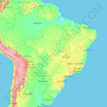
Name: Brazil topographic map, elevation, terrain.
Location: Brazil (-33.86943 -73.98306 5.26958 -28.62896)
Average elevation: 368 m
Minimum elevation: -2 m
Maximum elevation: 6,497 m
Other topographic maps
Click on a map to view its topography, its elevation and its terrain.
Europe
Europe's topography is characterized by a striking contrast between its rugged southern mountains and the expansive plains of the north. The continent is often described as a "peninsula of peninsulas," featuring major peninsulas like the Iberian, Italian, and Balkan, each with unique geological features. In…
Average elevation: 223 m
Mexico City
Mexico is crossed from north to south by two mountain ranges known as Sierra Madre Oriental and Sierra Madre Occidental, which are the extension of the Rocky Mountains from northern North America. From east to west at the center, the country is crossed by the Trans-Mexican Volcanic Belt also known as the…
Average elevation: 2,321 m
North America
North America's topography is characterized by its diverse and dramatic landscapes, stretching from the towering Rocky Mountains in the west to the expansive Great Plains in the central region, and the rugged Appalachian Mountains in the east. The Rocky Mountains, which include peaks exceeding 20,000 feet…
Average elevation: 294 m
Africa
Africa's topography is a complex tapestry of plateaus, mountains, valleys, and deserts. The continent is dominated by vast plateaus, with elevations averaging around 1,000 meters (3,281 feet), especially prominent in the south and east. The Ethiopian Highlands, often referred to as the "Roof of Africa," rise…
Average elevation: 462 m
Istanbul
Istanbul, located in northwestern Turkey, is a city that is uniquely situated across two continents, Europe and Asia, divided by the Bosphorus Strait. The city’s topography is characterized by a complex blend of hills, valleys, and coastal plains, which create a varied and scenic landscape. The European side…
Average elevation: 57 m
United Kingdom
Scotland accounts for just under a third (32 per cent) of the total area of the UK, covering 78,772 square kilometres (30,410 sq mi). This includes nearly eight hundred islands, predominantly west and north of the mainland; notably the Hebrides, Orkney Islands and Shetland Islands. Scotland is the most…
Average elevation: 79 m
Columbus
United States > Ohio > Franklin County > Columbus
The confluence of the Scioto and Olentangy rivers is just north-west of Downtown Columbus. Several smaller tributaries course through the Columbus metropolitan area, including Alum Creek, Big Walnut Creek, and Darby Creek. Columbus is considered to have relatively flat topography thanks to a large glacier that…
Average elevation: 255 m
South America
The east-central Brazilian plateau has a humid and warm tropical climate. The northern and eastern parts of the Argentine pampas have a humid subtropical climate with dry winters and humid summers of the Chinese type, while the western and eastern ranges have a subtropical climate of the dinaric type. At the…
Average elevation: 283 m
Amman
Jordan > Amman > Amman Sub-District
Amman is situated on the East Bank Plateau, an upland characterized by three major wadis which run through it. Originally, the city had been built on seven hills. Amman's terrain is typified by its mountains. The most important areas in the city are named after the hills or mountains they lie on. The area's…
Average elevation: 800 m
Johannesburg
South Africa > Gauteng > City of Johannesburg Metropolitan Municipality
Johannesburg is located in the eastern plateau area of South Africa known as the Highveld, at an elevation of 1,753 metres (5,751 ft). The former Central Business District is located on the southern side of the prominent ridge called the Witwatersrand (English: White Water's Ridge) and the terrain falls to the…
Average elevation: 1,615 m
Edinburgh
United Kingdom > Scotland > Edinburgh
Some have called Edinburgh the Athens of the North for a variety of reasons. The earliest comparison between the two cities showed that they had a similar topography, with the Castle Rock of Edinburgh performing a similar role to the Athenian Acropolis. Both of them had flatter, fertile agricultural land…
Average elevation: 104 m
Appalachian Mountains
United States > North Carolina > Yancey County
The Appalachian Mountains (French: Appalaches), often called the Appalachians, are a system of mountains in eastern to northeastern North America. The Appalachians first formed roughly 480 million years ago during the Ordovician Period. They once reached elevations similar to those of the Alps and the Rocky…
Average elevation: 1,463 m
Glasgow
United Kingdom > Scotland > Glasgow City
Glasgow itself was reputed to have been founded by the Christian missionary Saint Mungo in the 6th century. He established a church on the Molendinar Burn, where the present Glasgow Cathedral stands, and in the following years Glasgow became a religious centre. Glasgow grew over the following centuries. The…
Average elevation: 128 m
Asia
Average elevation: 563 m
Guadalajara
Mexico > Jalisco > Guadalajara
Under the Köppen climate classification, Guadalajara has a humid subtropical climate (Cwa), a temperate climate that is quite close to a tropical climate, featuring dry warm winters and wet, mildly hot summers. Guadalajara's climate is influenced by its high altitude and the general seasonality of…
Average elevation: 1,572 m
Karachi
Pakistan > Sindh > Karachi South District > Saddar Town
Karachi lies very close to a major fault line, where the Indian tectonic plate meets the Arabian tectonic plate. Within the city of Karachi are two small ranges: the Khasa Hills and Mulri Hills, which lie in the northwest and act as a barrier between North Nazimabad and Orangi. Karachi's hills are barren and…
Average elevation: 20 m
Athens
Greece > Attica > Regional Unit of Central Athens
Owing to the rain shadow of the Pindus Mountains, annual precipitation of Athens is lower than most other parts of Greece, especially western Greece. As an example, Ioannina receives around 1,300 mm (51 in) per year, and Agrinio around 800 mm (31 in) per year. Daily average highs for July have been measured…
Average elevation: 168 m
Scottsdale
United States > Arizona > Maricopa County > Scottsdale
The city is in the Salt River Valley, or the "Valley of the Sun," in the northern reaches of the Sonoran Desert. Scottsdale, 31 mi (50 km) long and 11.4 mi (18.3 km) wide at its widest point, shares boundaries with many other municipalities and entities. On the west, Scottsdale is bordered by Phoenix, Paradise…
Average elevation: 414 m
Bogota
The city is located in the center of Colombia, on a high plateau known as the Bogotá savanna, part of the Altiplano Cundiboyacense located in the Eastern Cordillera of the Andes. Its altitude averages 2,640 meters (8,660 ft) above sea level. Subdivided into 20 localities, Bogotá has an area of 1,587 square…
Average elevation: 2,735 m
Cape Town
South Africa > Western Cape > City of Cape Town
The Cape Peninsula is 52 km long from Mouille Point in the north to Cape Point in the south, with an area of about 470 km2, and it displays more topographical variety than other similar sized areas in southern Africa, and consequently spectacular scenery. There are diverse low-nutrient soils, large rocky…
Average elevation: 53 m
Baltimore
United States > Maryland > Baltimore
Baltimore is in north-central Maryland on the Patapsco River close to where it empties into the Chesapeake Bay. The city is also located on the fall line between the Piedmont Plateau and the Atlantic coastal plain, which divides Baltimore into "lower city" and "upper city". The city's elevation ranges from sea…
Average elevation: 65 m
Cambridge
United Kingdom > England > Cambridge
The city, like most of the UK, has a maritime climate highly influenced by the Gulf Stream. Located in the driest region of Britain, Cambridge's rainfall averages around 570 mm (22.44 in) per year, around half the national average, with some years occasionally falling into the semi-arid (under 500 mm (19.69…
Average elevation: 18 m
Ho Chi Minh City
Ho Chi Minh City is located in the south-eastern region of Vietnam, 1,760 km (1,090 mi) south of Hanoi. The average elevation is 5 m (16 ft) above sea level for the city center and 16 m (52 ft) for the suburb areas. It borders Tây Ninh Province and Bình Dương Province to the north, Đồng Nai Province and…
Average elevation: 6 m
Mount Washington
United States > New Hampshire > Coos County
Mount Washington, also known as Agiocochook, is an ultra-prominent mountain in the state of New Hampshire. It is the highest peak in the Northeastern United States at 6,288.2 ft (1,916.6 m) and the most topographically prominent mountain east of the Mississippi River.
Average elevation: 1,568 m
Cluj-Napoca
A wide variety of flora grow in the Cluj-Napoca Botanical Garden; some animals have also found refuge there. The city has a number of other parks, of which the largest is the Central Park. This park was founded during the 19th century and includes an artificial lake with an island, as well as the largest…
Average elevation: 490 m
Murree
Pakistan > Punjab > Murree District
Murree (Punjabi, Urdu: مری) is a mountain resort city, located in the Galyat region of the Pir Panjal Range, within the Muree District of Punjab, Pakistan. It forms the outskirts of the Islamabad-Rawalpindi metropolitan area, and is about 30 km (19 mi) northeast of Islamabad. It has average altitude of…
Average elevation: 1,718 m
Dhaka
Bangladesh > Dhaka Division > Dhaka Metropolitan
In 2013, suburban services to Narayanganj and Gazipur cities were upgraded using diesel electric multiple unit trains. The Dhaka Metro Rail feasibility study has been completed. A 20.1-kilometre (12.5 mi), $2.8-billion Phase 1 metro route is being negotiated by the Government with Japan International…
Average elevation: 7 m
Swindon
United Kingdom > England > Swindon
Swindon has an oceanic climate (Cfb in the Köppen climate classification), like the vast majority of the British Isles, with cool winters and warm summers. The nearest official weather station is RAF Lyneham, about 10 miles (16 km) west southwest of Swindon town centre. The weather station's elevation is 145…
Average elevation: 108 m
Islamabad
Pakistan > Islamabad Capital Territory
Islamabad is located at 33°26′N 73°02′E / 33.43°N 73.04°E / 33.43; 73.04 at the northern edge of the Pothohar Plateau and at the foot of the Margalla Hills in Islamabad Capital Territory. Its elevation is 540 metres (1,770 ft). The modern capital and the ancient Gakhar city of Rawalpindi form…
Average elevation: 666 m
Haifa
Haifa is the center of liberal Arabic-speaking culture, as it was under British colonial rule. The Arabic-speaking neighborhoods, which are mixed Muslim and Christian, are in the lowlands near the sea, while Jewish neighborhoods are at higher elevation. An active Arab cultural life has developed in the 21st…
Average elevation: 100 m
Kuala Lumpur
Located in the centre of Selangor state, Kuala Lumpur was a territory of Selangor State Government. In 1974, Kuala Lumpur was split off from Selangor to form the first Federal Territory governed directly by the Malaysian federal government. Its location in the most developed state on the west coast of…
Average elevation: 127 m
La Paz
Bolivia > La Paz > Pedro Domingo Murillo > La Paz
The city, in west-central Bolivia 68 km (42 mi) southeast of Lake Titicaca, is set in a canyon created by the Choqueyapu River. It is in a bowl-like depression, part of the Amazon basin, surrounded by the high mountains of the Altiplano. Overlooking the city is the towering, triple-peaked Illimani. Its peaks…
Average elevation: 4,087 m
Berlin
Berlin straddles the banks of the River Spree, which flows into the River Havel (a tributary of the River Elbe) in the western borough of Spandau. Among the city's main topographical features are the many lakes in the western and southeastern boroughs formed by the Spree, Havel, and Dahme rivers (the largest…
Average elevation: 47 m
Leeds
Lying in the eastern foothills of the Pennines, there is a significant variation in elevation within the city's built-up area. The district ranges from 1,115 feet (340 m) in the far west on the slopes of Ilkley Moor to about 33 feet (10 m) where the rivers Aire and Wharfe cross the eastern boundary. Land rises…
Average elevation: 94 m
Virginia Beach
United States > Virginia > Virginia Beach
According to the United States Census Bureau, the city has a total area of 497 square miles (1,290 km2), of which 249 square miles (640 km2) is land and 248 square miles (640 km2) (49.9%) is water. It is the largest city in Virginia by total area and third-largest city land area. The average elevation is 12…
Average elevation: 2 m
Kolkata
Spread roughly north–south along the east bank of the Hooghly River, Kolkata sits within the lower Ganges Delta of eastern India approximately 75 km (47 mi) west of the international border with Bangladesh; the city's elevation is 1.5–9 m (5–30 ft). Much of the city was originally a wetland that was…
Average elevation: 5 m
Jerusalem
Jerusalem is situated on the southern spur of a plateau in the Judaean Mountains, which include the Mount of Olives (East) and Mount Scopus (North East). The elevation of the Old City is approximately 760 m (2,490 ft). The whole of Jerusalem is surrounded by valleys and dry riverbeds (wadis). The Kidron,…
Average elevation: 520 m
Santiago
Chile > Santiago Metropolitan Region > Provincia de Santiago
The city lies in the center of the Santiago Basin, a large bowl-shaped valley consisting of broad and fertile lands surrounded by mountains. The city has a varying elevation, gradually increasing from 400 m (1,312 ft) in the western areas to more than 700 m (2,297 ft) in the eastern areas. Santiago's…
Average elevation: 722 m
Scandinavian Mountains
The mountain chain's highest summits are mostly concentrated in an area (of mean altitude of over 1,000 m) between Stavanger and Trondheim in South Norway, with numerous peaks over 1,300 m and some peaks over 2,000 m. Around Trondheim Fjord, peaks decrease in altitude to about 400–500 m rising again to…
Average elevation: 2,050 m
Cuernavaca
Mexico > Morelos > Cuernavaca
The city is located in a tropical region, but its temperature is fairly constant at 21–26 °C (70–79 °F). It is located on the southern slope of the Sierra de Chichinautzin mountains. In the morning, warm air flows up the mountains from the valley below and in the late afternoon, cooler air flows down…
Average elevation: 1,822 m
Riyadh
Riyadh has a hot desert climate (Köppen Climate Classification BWh), with long, extremely hot summers and short, very mild winters. The average high temperature in August is 43.6 °C (110.5 °F). If it was not for the elevation the city was on, Riyadh would experience an even hotter climate. The city…
Average elevation: 630 m
Medellín
Colombia > Antioquia > Medellín
Medellín has 16 comunas (districts), 5 corregimientos (townships), and 271 barrios (neighborhoods). The metropolitan area of Medellín lies within the Aburrá valley at an elevation of 1,500 metres (4,900 feet) above sea level and is bisected by the Medellín River (also called Porce), which flows northward.…
Average elevation: 2,098 m
Srinagar
India > Jammu and Kashmir > Srinagar (South)
Under the Köppen climate classification, Srinagar has a four-season humid subtropical climate (Cfa) with hot summers and cool winters. The valley is surrounded by the Himalayas on all sides. Due to influence from Himalayan rain shadow and western disturbances, Srinagar has year-round precipitation; the spring…
Average elevation: 1,805 m
Kefalonia
Greece > Peloponnese, Western Greece and the Ionian > Kefallonia Regional Unit
Average elevation: 60 m
Salisbury
United Kingdom > England > Salisbury
Bishop of Salisbury Hubert Walter was instrumental in the negotiations with Saladin during the Third Crusade, but he spent little time in his diocese prior to his elevation to archbishop of Canterbury. The brothers Herbert and Richard Poore succeeded him and began planning the relocation of the cathedral into…
Average elevation: 96 m
High Cup Nick
United Kingdom > England > Cumbria > Murton
The Pennine Way skirts the valley on its northern side by a traditional route known as Narrow Gate as it runs from Forest in Teesdale west via Cauldron Snout and Maize Beck to Dufton. This national trail briefly splits into two separate routes on either bank of Maize Beck; it is the southerly of the two which…
Average elevation: 601 m
Littleborough
In the late 18th century, the low-altitude Summit Gap between Littleborough and Walsden was approved as the best route over the Pennines for the Rochdale Canal and the Manchester to Leeds railway; Hollingworth Lake was built at Littleborough's south side as a feeder reservoir to regulate the waters of the…
Average elevation: 266 m