
Tibesti topographic map
Interactive map
Click on the map to display elevation.
About this map
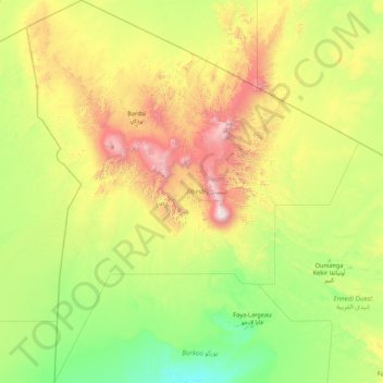
Name: Tibesti topographic map, elevation, terrain.
Location: Tibesti, Chad (16.94907 14.99858 23.45080 21.02467)
Average elevation: 665 m
Minimum elevation: 166 m
Maximum elevation: 3,353 m
Other topographic maps
Click on a map to view its topography, its elevation and its terrain.
Tibesti Mountains
Tibesti, which means "place where the mountain people live", is the domain of the Toubou people. The Toubou live mainly along the wadis, on rare oases where palm trees and limited grains grow. They harness the water that collects in gueltas, the supply of which is highly variable from year-to-year and…
Average elevation: 955 m
Tibesti Mountains
The highest peak in the Tibesti Mountains, as well as the highest point in Chad and the Sahara Desert, is the 3,415-meter (11,204 ft) Emi Koussi, located at the southern end of the range. Other prominent peaks include Pic Toussidé at 3,296 m (10,814 ft) and the 3,012-meter (9,882 ft) Timi on its western side,…
Average elevation: 1,430 m
Emi Koussi
Emi Koussi (also known as Emi Koussou) is a high pyroclastic shield volcano that lies at the southeast end of the Tibesti Mountains in the central Sahara, in the northern Borkou Region of northern Chad. The highest mountain of the Sahara, the volcano is one of several in the Tibesti range, and reaches an…
Average elevation: 2,904 m
Tibesti
Tibesti, which means "place where the mountain people live", is the domain of the Toubou people. The Toubou live mainly along the wadis, on rare oases where palm trees and limited grains grow. They harness the water that collects in gueltas, the supply of which is highly variable from year-to-year and…
Average elevation: 801 m
Moundou
Chad > Logone Occidental > Moundou
The first cadastral map of the town of Moundou was manufactured on 2 February 1926. Since there were not, at the time, the materials for substantial topographical surveys, the drainage pipeline of the town was facing the river in the belief that the natural inclination would head toward the river, when in…
Average elevation: 438 m