Geolocate

Karthikappally topographic map

Click on the map to display elevation.

About this map

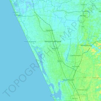
Name: Karthikappally topographic map, elevation, terrain.

Location: Karthikappally, Alappuzha District, Kerala, India (9.12428 76.38573 9.35283 76.54368)

Average elevation: 4 m

Minimum elevation: -4 m

Maximum elevation: 27 m

Other topographic maps

Click on a map to view its topography, its elevation and its terrain.

Kottayam

India > Kerala > Kottayam

Kottayam has an average elevation of 3 metres (9.8 ft) above sea level. and is situated in the basin of the Meenachil River and in the basin of the Vembanad backwaters, which are formed from several streams in the Western Ghats in Idukki district. According to the division of places in Kerala based on…

Average elevation: 19 m

Kochi

India > Kerala > Kochi

Average elevation: 4 m

Poopara

India > Kerala > Udumbanchola

Average elevation: 1,140 m

Kakkanad

India > Kerala > Kanayannur > Kakkanad

Average elevation: 13 m

Palakkad

India > Kerala > Palakkad

Average elevation: 205 m

Agali

India > Kerala > Mannarkad

Average elevation: 589 m

Panickankudy

India > Kerala > Idukki

Average elevation: 758 m

Vadakara

India > Kerala > Vadakara

Vatakara is located at 11°36′N 75°35′E / 11.60°N 75.58°E / 11.60; 75.58 and has an average elevation of 15 m (49 ft). It is situated about 49 km to the north of Kozhikode City, approximately 44 km to the south of Kannur City, and adjacent to Mahé. The town lies by the side of a river…

Average elevation: 12 m

Kolenchery

India > Kerala > Kunnathunad

Average elevation: 24 m

Mattom

India > Kerala > Kunnamkulam

Average elevation: 13 m

Velliangiri

India > Kerala > Mannarkad

Average elevation: 1,307 m

Silent Valley National Park

India > Kerala > Mannarkad

Average elevation: 1,103 m

Thiruvalla

India > Kerala > Thiruvalla

Thiruvalla lies at an altitude of 9 meters above sea level on the basin of the Pamba and Manimala rivers. Thiruvalla is dotted with several natural canal streams (called "thodu" in Malayalam) like Chanthathodu, Manippuzha, Mullelithodu, and several others. The city area has riverine alluvial soil, and eastern…

Average elevation: 10 m

Chithirapuram

India > Kerala > Devikulam

Average elevation: 1,063 m

Chevayur

India > Kerala > Kozhikode > Kozhikode

Average elevation: 32 m

Nooranad

India > Kerala > Mavelikkara

Average elevation: 30 m

Adivaram

India > Kerala > Thamarassery

Average elevation: 301 m

Kayamkulam

India > Kerala > Karthikappally > Kayamkulam

Average elevation: 8 m

Puthuppally

India > Kerala > Kottayam

Average elevation: 18 m

Ramapuram

India > Kerala > Meenachil

Average elevation: 60 m

Cheruthoni

India > Kerala > Idukki

Average elevation: 717 m

Thamarassery

India > Kerala > Thamarassery

Average elevation: 49 m

Valakom

India > Kerala > Kottarakkara

Average elevation: 79 m

Muttukadu colony

India > Kerala > Udumbanchola

Average elevation: 1,193 m

Vagamon Lake

India > Kerala > Peerumade > Vagamon

Average elevation: 976 m

Vattappara

India > Kerala > Nedumangad

Average elevation: 87 m

Periyar National Park Tiger Reserve

India > Kerala > Peerumade

Periyar National Park lies in the middle of a mountainous area of the Cardamom Hills. In the north, the boundary commences from the point nearest to the Medaganam in the interstate boundary up to Vellimalai. To the east the boundary follows the inter-state boundary from Vellimalai to Kallimalai Peak (1615 m)…

Average elevation: 929 m

Vazhakulam

India > Kerala > Muvattupuzha

Average elevation: 41 m

Edathode

India > Kerala > Vellarikkundu

Average elevation: 195 m

Chundale

India > Kerala

Average elevation: 798 m

Dwaraka

India > Kerala > Mananthavady

Average elevation: 746 m

Kolayad

India > Kerala > Thalassery

Average elevation: 81 m

Kattakada

India > Kerala > Kattakkada

Average elevation: 76 m

Rajakumari

India > Kerala > Udumbanchola

Average elevation: 1,001 m

Kodumbu

India > Kerala > Palakkad

Average elevation: 95 m

Kundara

India > Kerala > Kollam

Average elevation: 33 m

Chettapalam

India > Kerala > Mananthavady

Average elevation: 748 m

Kattangal

India > Kerala > Kozhikode

Average elevation: 41 m

Appachimedu

India > Kerala > Konni > Pamba

Average elevation: 301 m

Udiyankulangara

India > Kerala > Neyyattinkara

Average elevation: 39 m

Upputhara

India > Kerala > Upputhara

Upputhara is a village in Idukki district in the Indian state of Kerala. Upputhara panchayat, belonging to the block panchayat of Kattappana, is situated in the southern part of Idukki district in the Peermade taluk. The panchayat is bordered by the Periyar River in the east, the Meenmutti Lake in the west,…

Average elevation: 801 m

Manjeshwar

India > Kerala > Manjeswaram

Average elevation: 12 m

Thiruvambady

India > Kerala > Thamarassery

Average elevation: 46 m

Bharanikkavu

India > Kerala > Kunnathur

Average elevation: 23 m

Manakadavu

India > Kerala > Taliparamba

Average elevation: 272 m

Ulanadu

India > Kerala > Kozhencherry

Average elevation: 24 m

Moorthimon

India > Kerala > Konni > Thekkuthodu

Average elevation: 278 m

Idukki

India > Kerala > Idukki

Average elevation: 61 m

Vithura

India > Kerala > Nedumangad > Vithura

Average elevation: 132 m

Sakthikulangara

India > Kerala > Kollam

Average elevation: 4 m

Chirangara

India > Kerala > Chalakkudy

Average elevation: 20 m

Attingal

India > Kerala > Chirayinkeezhu

Average elevation: 25 m

Ottappalam

India > Kerala > Ottappalam

Ottapalam is located at 10°46′N 76°23′E / 10.77°N 76.38°E / 10.77; 76.38. It has an average elevation of 54 m (177 ft).

Average elevation: 41 m

Pathivayal

India > Kerala > Mananthavady > Mananthavady

Average elevation: 736 m

Kondotty

India > Kerala > Kondotty

Average elevation: 66 m

Nallur

India > Kerala > Kozhikode > Feroke

Average elevation: 13 m

Thaloor

India > Kerala > Sulthanbathery

Average elevation: 881 m

Kallanchira

India > Kerala > Hosdurg

Average elevation: 12 m

Changaleeri

India > Kerala > Mannarkad

Average elevation: 71 m

Kanjiramkulam

India > Kerala > Neyyattinkara

Average elevation: 51 m

Josegiri

India > Kerala > Taliparamba

Average elevation: 415 m

Angadipuram

India > Kerala > Perinthalmanna

Average elevation: 50 m

Thrippunithura

India > Kerala > Kanayannur

In the south, Thrippunithura borders the Vembanad, the longest lake in India. The lake provides facilities for inland water navigation, with the Champakkara canal stretch of the National Waterway 3 forming its western boundary with Kochi and Maradu. The canal then merges with the Chithrapuzha river in the…

Average elevation: 8 m

Elanthoor

India > Kerala > Kozhencherry

Average elevation: 38 m

Kallooppara

India > Kerala > Mallappally

The old Vemolinad was separated into "Vadakumkoor" and "Thekkumkoor" in AD 1100. Kottayam, Chenganacherry, Thiruvalla, Kanjirapally and some places of high range were included in Thekkumkoor kingdom. Kallooppara was under the control of the Thekkumkoor dynasty. It had Kalari (training center for martial arts)…

Average elevation: 19 m

Kodungallur

India > Kerala > Kodungallur

Average elevation: 5 m

Meenachil

India > Kerala > Kottayam > Pulikuttisseri

Average elevation: 6 m

Ramapuram

India > Kerala > Payyannur Taluk

Average elevation: 18 m

Kozhimala

India > Kerala > Idukki

Average elevation: 801 m

Mankada

India > Kerala > Perinthalmanna

Average elevation: 71 m

Vettichira

India > Kerala > Tirur

Average elevation: 68 m

Angamoozhy

India > Kerala > Konni

Angamoozhy is geographically a high-range area (Malanadu) situated in the south eastern part of Kerala and very close to the Western ghats mountain ranges. It has an average elevation of 18 m (59 ft) above sea level.

Average elevation: 233 m

Chennappara

India > Kerala > Udumbanchola > Thookkupalam

Average elevation: 933 m

Manathoor

India > Kerala > Meenachil > Pala

Average elevation: 102 m

Nellappara

India > Kerala > Meenachil

Average elevation: 496 m

basins

India > Kerala > Kunnathur > Kunnathur

Average elevation: 15 m

Vedikkuzhi

India > Kerala > Peerumade > Kolahalamedu

Average elevation: 1,004 m

Idukki Dam

India > Kerala > Idukki

Average elevation: 701 m

Thiruvanchoor

India > Kerala > Kottayam > Thiruvanchoor

Average elevation: 11 m

Ramamangalam

India > Kerala > Muvattupuzha > Ramamangalam

Average elevation: 25 m

Thirunelli

India > Kerala > Mananthavady

Average elevation: 969 m

Anjukunnu

India > Kerala > Mananthavady

Average elevation: 745 m

Peruva

India > Kerala > Vaikom

Average elevation: 25 m

Mannarkkad

India > Kerala > Mannarkad

Mannarkkad is located at 10°59′N 76°28′E / 10.98°N 76.47°E / 10.98; 76.47. It has an average elevation of 76 m (249 ft). Mannarkkad is located 36 km north-west of district headquarters Palakkad, along National Highway 966 and 100 km north west of Kozhikode. Mannarkkad is located in the…

Average elevation: 80 m

Charakadvu

India > Kerala > Hosdurg > Karuvakkode

Average elevation: 25 m

chullimanoor

India > Kerala > Nedumangad

Average elevation: 94 m

Pilathara

India > Kerala > Payyannur Taluk

Average elevation: 15 m

Paruthumpara

India > Kerala > Kottayam

Average elevation: 16 m

Karimugal

India > Kerala > Kunnathunad

Average elevation: 25 m

Pathanamthitta

India > Kerala

Pathanamthitta has an average elevation of 18 metres (62 ft) above sea level.

Average elevation: 63 m

Mullankunnu

India > Kerala > Vadakara

Average elevation: 49 m

Krishnapuram

India > Kerala > Karthikappally

Average elevation: 11 m

Morayur

India > Kerala > Kondotty

Average elevation: 65 m

Omassery

India > Kerala > Thamarassery

Average elevation: 42 m

Attappallam

India > Kerala > Peerumade > Kumily

Average elevation: 1,025 m

Kundala Dam

India > Kerala > Devikulam

Average elevation: 1,814 m

Arakkunnam

India > Kerala > Kanayannur

Average elevation: 29 m

Chaliyangod

India > Kerala > Kasaragod

Average elevation: 23 m

Gear up for your next adventure:

🧗Locking Carabiners - Secure gear to your pack or for light technical use
🛰️Satellite Messengers - Emergency communication devices for areas without mobile signal
🪓Outdoor Multitools - Versatile tools for hiking and camping
🛰️Handheld GPS Devices - Reliable GPS units for hiking and outdoor navigation
🌄Outdoor Binoculars - Compact binoculars for landscape observation

As an Amazon Associate, this site earns from qualifying purchases at no extra cost to you.