
Gedo topographic map
Interactive map
Click on the map to display elevation.
About this map
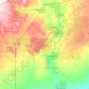
Name: Gedo topographic map, elevation, terrain.
Location: Gedo, Jubaland, Somalia (1.23078 40.98918 4.30698 43.14000)
Average elevation: 304 m
Minimum elevation: 41 m
Maximum elevation: 981 m
Other topographic maps
Click on a map to view its topography, its elevation and its terrain.
Mogadishu
Somalia > Banaadir > Hamar Weyne District
Mogadishu is located in or near the tropical thorn woodland biome of the Holdridge global bioclimatic scheme. The mean temperature in the city year-round is 27 °C (81 °F), with an average maximum of 30 °C (86 °F) and an average minimum of 24 °C (75 °F). Mean temperature readings per month vary by 3 °C…
Average elevation: 43 m
Somali Peninsula
Somalia > Bari > Qardho District
In Somalia, there is not much seasonal variation in climate. Hot conditions prevail year-round along with periodic monsoon winds and irregular rainfall. Mean daily maximum temperatures range from 28 to 43 °C (82 to 109 °F), except at higher elevations along the eastern seaboard, where the effects of a cold…
Average elevation: 840 m
Baidoa
Somalia > Bay > Baidoa District
Air transportation in Baidoa is served by the Baidoa Airport. Sitting at an elevation of 1,520 feet (463 m), it has a 9843 × 131 ft (3000 × 40 m) asphalt runway. The airport has fuel services, a terminal building, storage container, on-site warehouse, and radio towers.
Average elevation: 435 m
Mogadishu
Somalia > Banaadir > Hamar Weyne District
Mogadishu is located in or near the tropical thorn woodland biome of the Holdridge global bioclimatic scheme. The mean temperature in the city year round is 27 °C (81 °F), with an average maximum of 30 °C (86 °F) and an average minimum of 24 °C (75 °F). Mean temperature readings per month vary by 3 °C…
Average elevation: 43 m
Burao
Somalia > Togdheer > Burao District
Weather in Burao, much like other inland towns in Somaliland, is very warm to hot and dry year-round. The city has a hot arid climate (Köppen BWh) in common with most of Somalia, although Burao's weather is moderated by altitude. The average daytime temperatures during the summer months of June and August can…
Average elevation: 1,051 m
Bari
Somalia > Bari > Iskushuban
In terms of landmass, Bari is the largest province in the Federal Republic of Somalia. The highest point in this region is Mount Bahaya, the third tallest mountain in Somalia with an elevation of 2120 meters; other notable peaks include Karkaar and Cal Miskaad mountains.
Average elevation: 503 m
Mogadishu
Somalia > Banaadir > Hamar Weyne District
Mogadishu is located in or near the tropical thorn woodland biome of the Holdridge global bioclimatic scheme. The mean temperature in the city year round is 27 °C (81 °F), with an average maximum of 30 °C (86 °F) and an average minimum of 24 °C (75 °F). Mean temperature readings per month vary by 3 °C…
Average elevation: 43 m