
Make a donation
Gear up for your next adventure:
As an Amazon Associate, this site earns from qualifying purchases at no extra cost to you.
Austria topographic map
Click on the map to display elevation.
Gear up for your next adventure:
As an Amazon Associate, this site earns from qualifying purchases at no extra cost to you.
Austria
According to the Köppen Climate Classification Austria has the following climate types: Oceanic (Cfb), Cool/Warm-summer humid continental (Dfb), Subarctic/Subalpine (Dfc), Tundra/Alpine (ET) and Ice-Cap (EF). It is important to note though that Austria may experience very cold, severe winters, but most of the time they are only around as cold as those in somewhat comparable climate zones, for example Southern Scandinavia or Eastern Europe. As well, at higher altitudes, summers are usually considerably cooler than in the valleys/lower altitudes. The subarctic and tundra climates seen around the Alps are much warmer in winter than what is normal elsewhere due in part to the Oceanic influence on this part of Europe.
Make a donation
Gear up for your next adventure:
As an Amazon Associate, this site earns from qualifying purchases at no extra cost to you.
About this map
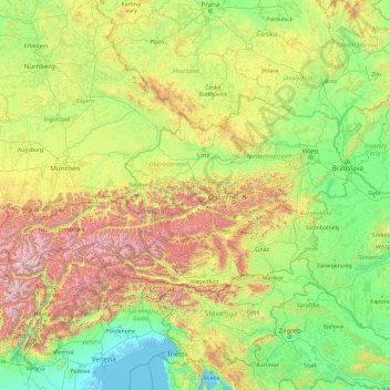
Name: Austria topographic map, elevation, terrain.
Location: Austria (46.37230 9.53075 49.02052 17.16077)
Average elevation: 595 m
Minimum elevation: -5 m
Maximum elevation: 3,694 m
Make a donation
Gear up for your next adventure:
As an Amazon Associate, this site earns from qualifying purchases at no extra cost to you.
Other topographic maps
Click on a map to view its topography, its elevation and its terrain.
Europe
Europe's topography is characterized by a striking contrast between its rugged southern mountains and the expansive plains of the north. The continent is often described as a "peninsula of peninsulas," featuring major peninsulas like the Iberian, Italian, and Balkan, each with unique geological features. In…
Average elevation: 223 m
Africa
Africa's topography is a complex tapestry of plateaus, mountains, valleys, and deserts. The continent is dominated by vast plateaus, with elevations averaging around 1,000 meters (3,281 feet), especially prominent in the south and east. The Ethiopian Highlands, often referred to as the "Roof of Africa," rise…
Average elevation: 462 m
Istanbul
Istanbul, located in northwestern Turkey, is a city that is uniquely situated across two continents, Europe and Asia, divided by the Bosphorus Strait. The city’s topography is characterized by a complex blend of hills, valleys, and coastal plains, which create a varied and scenic landscape. The European side…
Average elevation: 57 m
Make a donation
Gear up for your next adventure:
As an Amazon Associate, this site earns from qualifying purchases at no extra cost to you.
Edinburgh
United Kingdom > Scotland > Edinburgh
Some have called Edinburgh the Athens of the North for a variety of reasons. The earliest comparison between the two cities showed that they had a similar topography, with the Castle Rock of Edinburgh performing a similar role to the Athenian Acropolis. Both of them had flatter, fertile agricultural land…
Average elevation: 104 m
Little Saint James Island
United States > United States Virgin Islands > Saint Thomas - Saint John District
Average elevation: 1 m
Make a donation
Gear up for your next adventure:
As an Amazon Associate, this site earns from qualifying purchases at no extra cost to you.
Hull
United Kingdom > England > Kingston upon Hull
Kingston upon Hull is on the northern bank of the Humber Estuary. The city centre is west of the River Hull and close to the Humber. The city is built upon alluvial and glacial deposits which overlie chalk rocks but the underlying chalk has no influence on the topography. The land within the city is generally…
Average elevation: 21 m
Make a donation
Gear up for your next adventure:
As an Amazon Associate, this site earns from qualifying purchases at no extra cost to you.
Addis Ababa
Ethiopia > Addis Ababa > Arada
Moreover, the city held strong social organizations pattern prior Italian invasion. According to Richard Pankhurst (1968), the city accelerated population growth due to factors of provisional governors and their troops, the 1892 famine, eventually the Battle of Adwa. Another include the 1907 land act,…
Average elevation: 2,517 m
Make a donation
Gear up for your next adventure:
As an Amazon Associate, this site earns from qualifying purchases at no extra cost to you.
Glasgow
United Kingdom > Scotland > Glasgow City
Glasgow itself was reputed to have been founded by the Christian missionary Saint Mungo in the 6th century. He established a church on the Molendinar Burn, where the present Glasgow Cathedral stands, and in the following years Glasgow became a religious centre. Glasgow grew over the following centuries. The…
Average elevation: 128 m
Central Park
United States > New York > New York County > New York
In June 1856, Fernando Wood appointed a "consulting board" of seven people, headed by author Washington Irving, to inspire public confidence in the proposed development. Wood hired military engineer Egbert Ludovicus Viele as the park's chief engineer, tasking him with a topographical survey of the site. The…
Average elevation: 26 m
Portsmouth
United Kingdom > England > Hampshire > Portsmouth
By road, Portsmouth lies 73.5 miles (118.3 km) from Central London, 49.5 miles (79.7 km) west of Brighton, and 22.3 miles (35.9 km) east of Southampton. Portsmouth is situated primarily on Portsea Island and is the United Kingdom's only island city, although parts of it have expanded onto the mainland. Gosport…
Average elevation: 28 m
Make a donation
Gear up for your next adventure:
As an Amazon Associate, this site earns from qualifying purchases at no extra cost to you.
Berlin
Berlin straddles the banks of the River Spree, which flows into the River Havel (a tributary of the River Elbe) in the western borough of Spandau. Among the city's main topographical features are the many lakes in the western and southeastern boroughs formed by the Spree, Havel, and Dahme rivers (the largest…
Average elevation: 47 m
Riverside
United States of America > California > Riverside
Riverside is the 59th largest city in the United States, the 12th largest city in California, and the largest city in California's Inland Empire metro area. According to the United States Census Bureau, the city has a total area of 81.4 square miles (210.8 km2), of which 81.1 square miles (210 km2) is land and…
Average elevation: 351 m
Make a donation
Gear up for your next adventure:
As an Amazon Associate, this site earns from qualifying purchases at no extra cost to you.
Atlanta
United States > Georgia > Fulton County
Atlanta (/ætˈlæntə/ at-LAN-tə) is the capital and most populous city of the U.S. state of Georgia. It is the seat of Fulton County, the most populous county in Georgia. With a population of 498,715 living within the city limits, it is the eighth most populous city in the Southeast and 38th most populous…
Average elevation: 285 m
Mexico City
Mexico is crossed from north to south by two mountain ranges known as Sierra Madre Oriental and Sierra Madre Occidental, which are the extension of the Rocky Mountains from northern North America. From east to west at the center, the country is crossed by the Trans-Mexican Volcanic Belt also known as the…
Average elevation: 2,321 m
Make a donation
Gear up for your next adventure:
As an Amazon Associate, this site earns from qualifying purchases at no extra cost to you.
Cambridge
United Kingdom > England > Cambridge
The city, like most of the UK, has a maritime climate highly influenced by the Gulf Stream. Located in the driest region of Britain, Cambridge's rainfall averages around 570 mm (22.44 in) per year, around half the national average, with some years occasionally falling into the semi-arid (under 500 mm (19.69…
Average elevation: 18 m
Makrichori
Greece > Thessaly > Larisa Regional Unit > Municipal Unit of Makrichori
Average elevation: 139 m
Make a donation
Gear up for your next adventure:
As an Amazon Associate, this site earns from qualifying purchases at no extra cost to you.
Make a donation
Gear up for your next adventure:
As an Amazon Associate, this site earns from qualifying purchases at no extra cost to you.
Karachi
Pakistan > Sindh > Karachi South District > Saddar Town
Karachi lies very close to a major fault line, where the Indian tectonic plate meets the Arabian tectonic plate. Within the city of Karachi are two small ranges: the Khasa Hills and Mulri Hills, which lie in the northwest and act as a barrier between North Nazimabad and Orangi. Karachi's hills are barren and…
Average elevation: 20 m
Mediterranean Sea
Average elevation: 0 m
Make a donation
Gear up for your next adventure:
As an Amazon Associate, this site earns from qualifying purchases at no extra cost to you.
Bratislava
Slovakia > Region of Bratislava > District of Bratislava I > Old Town
The Carpathian mountain range begins in city territory with the Little Carpathians (Malé Karpaty). The Záhorie and Danubian lowlands stretch into Bratislava. The city's lowest point is at the Danube's surface at 126 metres (413 ft) above mean sea level, and the highest point is Devínska Kobyla at 514 metres…
Average elevation: 175 m
Asia
Average elevation: 563 m
Islamabad
Pakistan > Islamabad Capital Territory
Islamabad is located at 33°26′N 73°02′E / 33.43°N 73.04°E / 33.43; 73.04 at the northern edge of the Pothohar Plateau and at the foot of the Margalla Hills in Islamabad Capital Territory. Its elevation is 540 metres (1,770 ft). The modern capital and the ancient Gakhar city of Rawalpindi form…
Average elevation: 666 m
Baltimore
United States > Maryland > Baltimore
Baltimore is in north-central Maryland on the Patapsco River close to where it empties into the Chesapeake Bay. The city is also located on the fall line between the Piedmont Plateau and the Atlantic coastal plain, which divides Baltimore into "lower city" and "upper city". The city's elevation ranges from sea…
Average elevation: 65 m
Make a donation
Gear up for your next adventure:
As an Amazon Associate, this site earns from qualifying purchases at no extra cost to you.
Swansea
United Kingdom > Wales > Swansea
Much of Swansea is hilly with the main area of upland being located in the council ward of Mawr. Areas up to 185 metres (607 ft) in elevation range across the central section: Kilvey Hill, Townhill and Llwynmawr separate the centre of Swansea from its northern suburbs. Cefn Bryn, a ridge of high land, is the…
Average elevation: 73 m
Snowdon
United Kingdom > Wales > Gwynedd
Snowdon (/ˈsnoʊdən/) or Yr Wyddfa (pronounced [ər ˈʊɨ̞̯ðva] (listen)), is the highest mountain in Wales, at an elevation of 1,085 metres (3,560 ft) above sea level, and the highest point in the British Isles outside the Scottish Highlands. It is located in Snowdonia National Park (Parc Cenedlaethol…
Average elevation: 692 m
United Kingdom
Scotland accounts for just under a third (32 per cent) of the total area of the UK, covering 78,772 square kilometres (30,410 sq mi). This includes nearly eight hundred islands, predominantly west and north of the mainland; notably the Hebrides, Orkney Islands and Shetland Islands. Scotland is the most…
Average elevation: 79 m
Make a donation
Gear up for your next adventure:
As an Amazon Associate, this site earns from qualifying purchases at no extra cost to you.
Matterhorn
Italy > Aosta Valley > Valtournenche
In 1999, the summit height was precisely determined to be at 4,477.54 m (14,690 ft) above sea level by using Global Positioning System technology as part of the TOWER Project (Top of the World Elevations Remeasurement) and to an accuracy of less than one centimetre, which allows future changes to be tracked.
Average elevation: 3,295 m
North America
North America's topography is characterized by its diverse and dramatic landscapes, stretching from the towering Rocky Mountains in the west to the expansive Great Plains in the central region, and the rugged Appalachian Mountains in the east. The Rocky Mountains, which include peaks exceeding 20,000 feet…
Average elevation: 294 m
Riyadh
Riyadh has a hot desert climate (Köppen Climate Classification BWh), with long, extremely hot summers and short, very mild winters. The average high temperature in August is 43.6 °C (110.5 °F). If it was not for the elevation the city was on, Riyadh would experience an even hotter climate. The city…
Average elevation: 630 m
Make a donation
Gear up for your next adventure:
As an Amazon Associate, this site earns from qualifying purchases at no extra cost to you.
Columbus
United States > Ohio > Franklin County > Columbus
The confluence of the Scioto and Olentangy rivers is just north-west of Downtown Columbus. Several smaller tributaries course through the Columbus metropolitan area, including Alum Creek, Big Walnut Creek, and Darby Creek. Columbus is considered to have relatively flat topography thanks to a large glacier that…
Average elevation: 255 m
Make a donation
Gear up for your next adventure:
As an Amazon Associate, this site earns from qualifying purchases at no extra cost to you.
Pittsburgh
United States of America > Pennsylvania > Pittsburgh
The warmest month of the year in Pittsburgh is July, with a 24-hour average of 72.6 °F (22.6 °C). Conditions are often humid, and combined with highs reaching 90 °F (32 °C) on an average 9.5 days a year, a considerable heat index arises. The coolest month is January, when the 24-hour average is 28.4 °F…
Average elevation: 315 m
South America
The east-central Brazilian plateau has a humid and warm tropical climate. The northern and eastern parts of the Argentine pampas have a humid subtropical climate with dry winters and humid summers of the Chinese type, while the western and eastern ranges have a subtropical climate of the dinaric type. At the…
Average elevation: 283 m
Scottish Highlands
United Kingdom > Scotland > Highland
The entire region was covered by ice sheets during the Pleistocene ice ages, save perhaps for a few nunataks. The complex geomorphology includes incised valleys and lochs carved by the action of mountain streams and ice, and a topography of irregularly distributed mountains whose summits have similar heights…
Average elevation: 907 m
Make a donation
Gear up for your next adventure:
As an Amazon Associate, this site earns from qualifying purchases at no extra cost to you.
Kolkata
Spread roughly north–south along the east bank of the Hooghly River, Kolkata sits within the lower Ganges Delta of eastern India approximately 75 km (47 mi) west of the international border with Bangladesh; the city's elevation is 1.5–9 m (5–30 ft). Much of the city was originally a wetland that was…
Average elevation: 5 m
Make a donation
Gear up for your next adventure:
As an Amazon Associate, this site earns from qualifying purchases at no extra cost to you.
Scottsdale
United States > Arizona > Maricopa County > Scottsdale
The city is in the Salt River Valley, or the "Valley of the Sun," in the northern reaches of the Sonoran Desert. Scottsdale, 31 mi (50 km) long and 11.4 mi (18.3 km) wide at its widest point, shares boundaries with many other municipalities and entities. On the west, Scottsdale is bordered by Phoenix, Paradise…
Average elevation: 414 m
Rome
Italy > Lazio > Roma Capitale
Although the city centre is about 24 km (15 mi) inland from the Tyrrhenian Sea, the city territory extends to the shore, where the south-western district of Ostia is located. The altitude of the central part of Rome ranges from 13 m (43 ft) above sea level (at the base of the Pantheon) to 139 m (456 ft) above…
Average elevation: 78 m
Make a donation
Gear up for your next adventure:
As an Amazon Associate, this site earns from qualifying purchases at no extra cost to you.
Make a donation
Gear up for your next adventure:
As an Amazon Associate, this site earns from qualifying purchases at no extra cost to you.
Hamburg
The neighborhoods of Neuenfelde, Cranz, Francop and Finkenwerder are part of the Altes Land (old land) region, the largest contiguous fruit-producing region in Central Europe. Neugraben-Fischbek has Hamburg's highest elevation, the Hasselbrack at 116.2 metres (381 ft) AMSL. Hamburg borders the states of…
Average elevation: 23 m
Gaza
Central Gaza is situated on a low-lying and round hill with an elevation of 14 metres (46 ft) above sea level. Much of the modern city is built along the plain below the hill, especially to the north and east, forming Gaza's suburbs. The beach and the port of Gaza are located 3 kilometres (1.9 mi) west of the…
Average elevation: 41 m
Make a donation
Gear up for your next adventure:
As an Amazon Associate, this site earns from qualifying purchases at no extra cost to you.
Johannesburg
South Africa > Gauteng > City of Johannesburg Metropolitan Municipality
Johannesburg is located in the eastern plateau area of South Africa known as the Highveld, at an elevation of 1,753 metres (5,751 ft). The former Central Business District is located on the southern side of the prominent ridge called the Witwatersrand (English: White Water's Ridge) and the terrain falls to the…
Average elevation: 1,615 m
Make a donation
Gear up for your next adventure:
As an Amazon Associate, this site earns from qualifying purchases at no extra cost to you.
Make a donation
Gear up for your next adventure:
As an Amazon Associate, this site earns from qualifying purchases at no extra cost to you.
Make a donation
Gear up for your next adventure:
As an Amazon Associate, this site earns from qualifying purchases at no extra cost to you.
Kuala Lumpur
Located in the centre of Selangor state, Kuala Lumpur was a territory of Selangor State Government. In 1974, Kuala Lumpur was split off from Selangor to form the first Federal Territory governed directly by the Malaysian federal government. Its location in the most developed state on the west coast of…
Average elevation: 127 m
Make a donation
Gear up for your next adventure:
As an Amazon Associate, this site earns from qualifying purchases at no extra cost to you.
Leeds
Lying in the eastern foothills of the Pennines, there is a significant variation in elevation within the city's built-up area. The district ranges from 1,115 feet (340 m) in the far west on the slopes of Ilkley Moor to about 33 feet (10 m) where the rivers Aire and Wharfe cross the eastern boundary. Land rises…
Average elevation: 94 m
San Diego
United States > California > San Diego County > San Diego
The climate in San Diego, like most of Southern California, often varies significantly over short geographical distances, resulting in microclimates. In San Diego, this is mostly because of the city's topography (the Bay, and the numerous hills, mountains, and canyons). Frequently, particularly during the "May…
Average elevation: 57 m
Make a donation
Gear up for your next adventure:
As an Amazon Associate, this site earns from qualifying purchases at no extra cost to you.
Mongewell
United Kingdom > England > Oxfordshire > South Oxfordshire > Crowmarsh Gifford
Average elevation: 59 m
Make a donation
Gear up for your next adventure:
As an Amazon Associate, this site earns from qualifying purchases at no extra cost to you.