
Kearny County topographic map
Interactive map
Click on the map to display elevation.
About this map
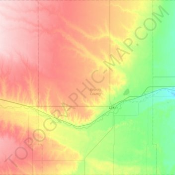
Name: Kearny County topographic map, elevation, terrain.
Location: Kearny County, Kansas, United States (37.73607 -101.54242 38.26401 -101.08963)
Average elevation: 971 m
Minimum elevation: 881 m
Maximum elevation: 1,082 m
Other topographic maps
Click on a map to view its topography, its elevation and its terrain.
Maple Hill
United States > Kansas > Wabaunsee County
Maple Hill was founded about 1882. It was named from a grove of maple trees growing upon an elevation.
Average elevation: 298 m
Scott City
United States > Kansas > Scott County
According to the United States Census Bureau, the city has a total area of 2.63 square miles (6.81 km2), all land. It is located in the Great Plains and at the elevation of 2979 ft.
Average elevation: 903 m
Lawrence
United States > Kansas > Douglas County
Lawrence is located at coordinates 38.9716689, -95.2352501 in the state of Kansas, approximately 25 miles (40 kilometers) east of Topeka, and 35 mi (56 km) west of Kansas City, Kansas. Though Lawrence has a designated elevation of 866 feet (264 m), the highest elevation is Mount Oread on the University of…
Average elevation: 265 m
Wichita
United States > Kansas > Sedgwick County
The city lies on the Arkansas River near the western edge of the Flint Hills in the Wellington-McPherson Lowlands region of the Great Plains. The area's topography is characterized by the broad alluvial plain of the Arkansas River valley and the moderately rolling slopes that rise to the higher lands on either…
Average elevation: 408 m
Garden City
United States > Kansas > Finney County
Garden City is at 37°58′31″N 100°51′51″W / 37.97528°N 100.86417°W / 37.97528; -100.86417 at an elevation of 2,838 feet (865 m). The city lies on the north side of the Arkansas River in the High Plains region of the Great Plains. It is located in southwestern Kansas at the intersection of…
Average elevation: 870 m
Salina
United States > Kansas > Saline County
Salina is located at 38°50′25″N 97°36′41″W / 38.84028°N 97.61139°W / 38.84028; -97.61139 (38.8402805, -97.6114237) at an elevation of 1,224 feet (373 m). Located in North Central Kansas at the intersection of Interstate 70 and Interstate 135, it is 81 miles (130 km) north of Wichita,…
Average elevation: 383 m
Dodge City
United States > Kansas > Ford County
Dodge City is located at 37°45′35″N 100°1′6″W / 37.75972°N 100.01833°W / 37.75972; -100.01833 (37.759671, −100.018212) at an elevation of 2,493 ft (760 m). It lies on the Arkansas River in the High Plains region of the Great Plains. The city sits above one of the world's largest…
Average elevation: 777 m
Great Plains
United States > Kansas > Thomas County
The North American Environmental Atlas, produced by the Commission for Environmental Cooperation, a NAFTA agency composed of the geographical agencies of the Mexican, American, and Canadian governments, uses the "Great Plains" as an ecoregion synonymous with predominant prairies and grasslands rather than as…
Average elevation: 1,023 m
Leavenworth
United States > Kansas > Leavenworth County > Leavenworth
Leavenworth is located at 39°18′40″N 94°55′21″W / 39.31111°N 94.92250°W / 39.31111; -94.92250 (39.3111112, −94.9224637) at an elevation of 840 feet (256 m).[5] Located in northeastern Kansas at the junction of U.S. Route 73 and Kansas Highway 92 (K-92), Leavenworth is 25 mi (40 km)…
Average elevation: 277 m
Colby
United States > Kansas > Thomas County > Colby
Colby is located at 39°23′32″N 101°02′51″W / 39.392093°N 101.047532°W / 39.392093; -101.047532 (39.392093, -101.047532) at an elevation of 3,159 feet (963 m). It lies on the south side of Prairie Dog Creek, a tributary of the Republican River, in the High Plains region of the Great Plains.…
Average elevation: 970 m
Fort Scott
United States > Kansas > Bourbon County > Fort Scott
Fort Scott is located at 37°50′7″N 94°42′7″W / 37.83528°N 94.70194°W / 37.83528; -94.70194 (37.835180, −94.702015) at an elevation of 846 feet (258 m). It lies on the Osage Plains on the south side of the Marmaton River. Located at the intersection of U.S. Routes 54 and 69 in southeast…
Average elevation: 260 m