
Turkey topographic map
Interactive map
Click on the map to display elevation.
Turkey
Turkey's topography is a diverse tapestry of mountains, plateaus, and coastal plains that create a strikingly varied landscape. The country is predominantly characterized by the Anatolian Plateau, a semi-arid highland that stretches across central Turkey, with elevations ranging from 700 to 2,000 meters. This plateau is flanked by the Pontic Mountains to the north and the Taurus Mountains to the south, both of which run parallel to the respective coastlines. In the east, the terrain becomes more rugged and elevated, culminating in Mount Ararat, Turkey's highest peak at 5,137 meters. Coastal regions, such as the Aegean and Mediterranean shores, feature narrow plains that give way to rolling hills and steep mountains, while the Black Sea coast is lined with dense forests and receives the highest precipitation in the country. This complex terrain not only shapes Turkey's diverse climates and ecosystems but also influences human activities, from agriculture in the fertile basins to tourism in the picturesque valleys and mountains.
About this map
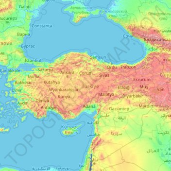
Name: Turkey topographic map, elevation, terrain.
Location: Turkey (35.80590 25.56563 42.29700 44.81766)
Average elevation: 487 m
Minimum elevation: -415 m
Maximum elevation: 5,225 m
Other topographic maps
Click on a map to view its topography, its elevation and its terrain.
Europe
Europe's topography is characterized by a striking contrast between its rugged southern mountains and the expansive plains of the north. The continent is often described as a "peninsula of peninsulas," featuring major peninsulas like the Iberian, Italian, and Balkan, each with unique geological features. In…
Average elevation: 223 m
Africa
Africa's topography is a complex tapestry of plateaus, mountains, valleys, and deserts. The continent is dominated by vast plateaus, with elevations averaging around 1,000 meters (3,281 feet), especially prominent in the south and east. The Ethiopian Highlands, often referred to as the "Roof of Africa," rise…
Average elevation: 462 m
Istanbul
Istanbul, located in northwestern Turkey, is a city that is uniquely situated across two continents, Europe and Asia, divided by the Bosphorus Strait. The city’s topography is characterized by a complex blend of hills, valleys, and coastal plains, which create a varied and scenic landscape. The European side…
Average elevation: 57 m
North America
North America's topography is characterized by its diverse and dramatic landscapes, stretching from the towering Rocky Mountains in the west to the expansive Great Plains in the central region, and the rugged Appalachian Mountains in the east. The Rocky Mountains, which include peaks exceeding 20,000 feet…
Average elevation: 294 m
Edinburgh
United Kingdom > Scotland > Edinburgh
Some have called Edinburgh the Athens of the North for a variety of reasons. The earliest comparison between the two cities showed that they had a similar topography, with the Castle Rock of Edinburgh performing a similar role to the Athenian Acropolis. Both of them had flatter, fertile agricultural land…
Average elevation: 104 m
United Kingdom
Scotland accounts for just under a third (32 per cent) of the total area of the UK, covering 78,772 square kilometres (30,410 sq mi). This includes nearly eight hundred islands, predominantly west and north of the mainland; notably the Hebrides, Orkney Islands and Shetland Islands. Scotland is the most…
Average elevation: 79 m
Ural Mountains
Russia > Khanty-Mansiysk Autonomous Okrug – Ugra > Beryozovsky District
The Ural Mountains (/ˈjʊərəl/ YOOR-əl; Russian: Ура́льские го́ры, tr. Uralskiye gory, IPA: [ʊˈralʲskʲɪjə ˈɡorɨ]; Bashkir: Урал тауҙары) or simply the Urals, are a mountain range in Eurasia that runs north-south mostly through Russia, from the coast of the Arctic Ocean to…
Average elevation: 1,435 m
Mount Washington
United States > New Hampshire > Coos County
Mount Washington, also known as Agiocochook, is an ultra-prominent mountain in the state of New Hampshire. It is the highest peak in the Northeastern United States at 6,288.2 ft (1,916.6 m) and the most topographically prominent mountain east of the Mississippi River.
Average elevation: 1,568 m
City of London
United Kingdom > England > City of London > City of London
The elevation of the City ranges from sea level at the Thames to 21.6 metres (71 ft) at the junction of High Holborn and Chancery Lane. Two small but notable hills are within the historic core, Ludgate Hill to the west and Cornhill to the east. Between them ran the Walbrook, one of the many "lost" rivers or…
Average elevation: 42 m
Kuala Lumpur
Located in the centre of Selangor state, Kuala Lumpur was a territory of Selangor State Government. In 1974, Kuala Lumpur was split off from Selangor to form the first Federal Territory governed directly by the Malaysian federal government. Its location in the most developed state on the west coast of…
Average elevation: 127 m
Columbus
United States > Ohio > Franklin County > Columbus
The confluence of the Scioto and Olentangy rivers is just north-west of Downtown Columbus. Several smaller tributaries course through the Columbus metropolitan area, including Alum Creek, Big Walnut Creek, and Darby Creek. Columbus is considered to have relatively flat topography thanks to a large glacier that…
Average elevation: 255 m
Riverside
United States of America > California > Riverside
Riverside is the 59th largest city in the United States, the 12th largest city in California, and the largest city in California's Inland Empire metro area. According to the United States Census Bureau, the city has a total area of 81.4 square miles (210.8 km2), of which 81.1 square miles (210 km2) is land and…
Average elevation: 351 m
Swansea
United Kingdom > Wales > Swansea
Much of Swansea is hilly with the main area of upland being located in the council ward of Mawr. Areas up to 185 metres (607 ft) in elevation range across the central section: Kilvey Hill, Townhill and Llwynmawr separate the centre of Swansea from its northern suburbs. Cefn Bryn, a ridge of high land, is the…
Average elevation: 73 m
Reading
United Kingdom > England > Reading
Mary Russell Mitford lived in Reading for a number of years and then spent the rest of her life just outside the town at Three Mile Cross and Swallowfield. The fictional Belford Regis of her eponymous novel, first published in 1835, is largely based on Reading. Described with topographical accuracy, it is…
Average elevation: 56 m
Highlands
United States > North Carolina > Macon County > Highlands
Highlands was founded in 1875 after its two founders, Samuel Truman Kelsey and Clinton Carter Hutchinson, drew lines from Chicago to Savannah and from New Orleans to New York City. They felt that the place where these lines met would eventually become a great trading center and commercial crossroads. Highlands…
Average elevation: 1,090 m
Mrkovići
Bosnia and Herzegovina > Federation of Bosnia and Herzegovina > City of Sarajevo
Average elevation: 938 m
Piedra
United States > California > Fresno County
Piedra (Spanish for "Stone") is an unincorporated community in Fresno County, California. It is located on the south bank of the Kings River 23 miles (37 km) east of Fresno, at an elevation of 538 feet (164 m).
Average elevation: 263 m
Crescent City
United States > California > Del Norte County
The topography of the sea floor surrounding Crescent City has the effect of focusing tsunamis. According to researchers at Humboldt State University and the University of Southern California, the city experienced tsunami conditions 31 times between the years 1933 and 2008. Although many of these incidents were…
Average elevation: 31 m
Basingstoke
United Kingdom > England > Hampshire > Basingstoke and Deane
Situated in a valley through the Hampshire Downs at an average elevation of 88 metres (289 ft) Basingstoke is a major interchange between Reading, Newbury, Andover, Winchester, and Alton, and lies on the natural trade route between the southwest of England and London. The area had been something of an…
Average elevation: 110 m
Virginia Beach
United States > Virginia > Virginia Beach
According to the United States Census Bureau, the city has a total area of 497 square miles (1,290 km2), of which 249 square miles (640 km2) is land and 248 square miles (640 km2) (49.9%) is water. It is the largest city in Virginia by total area and third-largest city land area. The average elevation is 12…
Average elevation: 2 m
Scottsdale
United States > Arizona > Maricopa County > Scottsdale
The city is in the Salt River Valley, or the "Valley of the Sun," in the northern reaches of the Sonoran Desert. Scottsdale, 31 mi (50 km) long and 11.4 mi (18.3 km) wide at its widest point, shares boundaries with many other municipalities and entities. On the west, Scottsdale is bordered by Phoenix, Paradise…
Average elevation: 414 m
Pokhara
Pokhara is in the northwestern corner of the Pokhara Valley, which is a widening of the Seti Gandaki valley that lies in the region (Pahad) of the Himalayas. In this region the mountains rise very quickly, and within 30 kilometres (19 miles), the elevation rises from 1,000 to 7,500 metres (3,300 to 24,600…
Average elevation: 1,222 m
Berlin
Berlin straddles the banks of the River Spree, which flows into the River Havel (a tributary of the River Elbe) in the western borough of Spandau. Among the city's main topographical features are the many lakes in the western and southeastern boroughs formed by the Spree, Havel, and Dahme rivers (the largest…
Average elevation: 47 m
San Diego
United States > California > San Diego County > San Diego
The climate in San Diego, like most of Southern California, often varies significantly over short geographical distances, resulting in microclimates. In San Diego, this is mostly because of the city's topography (the Bay, and the numerous hills, mountains, and canyons). Frequently, particularly during the "May…
Average elevation: 57 m
Central Park
United States > New York > New York County > New York
In June 1856, Fernando Wood appointed a "consulting board" of seven people, headed by author Washington Irving, to inspire public confidence in the proposed development. Wood hired military engineer Egbert Ludovicus Viele as the park's chief engineer, tasking him with a topographical survey of the site. The…
Average elevation: 26 m
Perth
Australia > Western Australia > City of Perth
Perth, the capital of Western Australia, is situated on the Swan Coastal Plain, a flat expanse of sandy soil nestled between the Indian Ocean to the west and the Darling Scarp to the east. The Darling Scarp, also known as the Darling Range, is a low escarpment that extends north–south, marking a distinct…
Average elevation: 26 m
Murree
Pakistan > Punjab > Murree District
Murree (Punjabi, Urdu: مری) is a mountain resort city, located in the Galyat region of the Pir Panjal Range, within the Muree District of Punjab, Pakistan. It forms the outskirts of the Islamabad-Rawalpindi metropolitan area, and is about 30 km (19 mi) northeast of Islamabad. It has average altitude of…
Average elevation: 1,718 m
Baltimore
United States > Maryland > Baltimore
Baltimore is in north-central Maryland on the Patapsco River close to where it empties into the Chesapeake Bay. The city is also located on the fall line between the Piedmont Plateau and the Atlantic coastal plain, which divides Baltimore into "lower city" and "upper city". The city's elevation ranges from sea…
Average elevation: 65 m
Kolkata
Spread roughly north–south along the east bank of the Hooghly River, Kolkata sits within the lower Ganges Delta of eastern India approximately 75 km (47 mi) west of the international border with Bangladesh; the city's elevation is 1.5–9 m (5–30 ft). Much of the city was originally a wetland that was…
Average elevation: 5 m
Karachi
Pakistan > Sindh > Karachi South District > Saddar Town
Karachi lies very close to a major fault line, where the Indian tectonic plate meets the Arabian tectonic plate. Within the city of Karachi are two small ranges: the Khasa Hills and Mulri Hills, which lie in the northwest and act as a barrier between North Nazimabad and Orangi. Karachi's hills are barren and…
Average elevation: 20 m
Sochi
Russia > Krasnodar Krai > Resort Town of Sochi (municipal formation)
Sochi has a humid subtropical climate (Köppen climate classification Cfa), at the lower elevations. Its average annual temperature is 18.9 °C (66.0 °F) during the day and 11.5 °C (52.7 °F) at night. In the coldest months—January and February—the average temperature is about 10 °C (50 °F) during the…
Average elevation: 148 m
Snowdon
United Kingdom > Wales > Gwynedd
Snowdon (/ˈsnoʊdən/) or Yr Wyddfa (pronounced [ər ˈʊɨ̞̯ðva] (listen)), is the highest mountain in Wales, at an elevation of 1,085 metres (3,560 ft) above sea level, and the highest point in the British Isles outside the Scottish Highlands. It is located in Snowdonia National Park (Parc Cenedlaethol…
Average elevation: 692 m
Black Hills
United States > South Dakota > Pennington County
The Black Hills is an isolated mountain range rising from the Great Plains of North America in western South Dakota and extending into Wyoming, United States. Black Elk Peak, which rises to 7,242 feet (2,207 m), is the range's highest summit. The name of the range in Lakota is Pahá Sápa. It encompasses the…
Average elevation: 1,894 m
Panskura
India > West Bengal > Panskura
Panskura is located at 22°25′N 87°42′E / 22.42°N 87.7°E / 22.42; 87.7. It has an average elevation of 7 metres (26 feet). It is situated on the NH6 on the way from Kolkata to Kharagpur.
Average elevation: 7 m
Western Ghats
The range starts near south of the Tapti river and runs approximately 1,600 km (990 mi) through the states of Gujarat, Maharashtra, Karnataka, Goa, Kerala and Tamil Nadu ending at Marunthuvazh Malai, Swamithope near the southern tip of India. These hills cover 160,000 km2 (62,000 sq mi) and form the catchment…
Average elevation: 2,225 m
Asia
Average elevation: 563 m
Athens
Greece > Attica > Regional Unit of Central Athens
Owing to the rain shadow of the Pindus Mountains, annual precipitation of Athens is lower than most other parts of Greece, especially western Greece. As an example, Ioannina receives around 1,300 mm (51 in) per year, and Agrinio around 800 mm (31 in) per year. Daily average highs for July have been measured…
Average elevation: 168 m
Riyadh
Riyadh has a hot desert climate (Köppen Climate Classification BWh), with long, extremely hot summers and short, very mild winters. The average high temperature in August is 43.6 °C (110.5 °F). If it was not for the elevation the city was on, Riyadh would experience an even hotter climate. The city…
Average elevation: 630 m
Portsmouth
United Kingdom > England > Hampshire > Portsmouth
By road, Portsmouth lies 73.5 miles (118.3 km) from Central London, 49.5 miles (79.7 km) west of Brighton, and 22.3 miles (35.9 km) east of Southampton. Portsmouth is situated primarily on Portsea Island and is the United Kingdom's only island city, although parts of it have expanded onto the mainland. Gosport…
Average elevation: 28 m
Cambridge
United Kingdom > England > Cambridge
The city, like most of the UK, has a maritime climate highly influenced by the Gulf Stream. Located in the driest region of Britain, Cambridge's rainfall averages around 570 mm (22.44 in) per year, around half the national average, with some years occasionally falling into the semi-arid (under 500 mm (19.69…
Average elevation: 18 m
Glasgow
United Kingdom > Scotland > Glasgow City
Glasgow itself was reputed to have been founded by the Christian missionary Saint Mungo in the 6th century. He established a church on the Molendinar Burn, where the present Glasgow Cathedral stands, and in the following years Glasgow became a religious centre. Glasgow grew over the following centuries. The…
Average elevation: 128 m
Holbeach Marsh
United Kingdom > England > Lincolnshire > South Holland > Holbeach CP > Holbeach St Marks
Average elevation: 4 m