
Erdek topographic map
Click on the map to display elevation.
Erdek
Erdek (formerly known as Artàke, Greek: Αρτάκη) is a municipality and district of Balıkesir Province, Turkey. Its area is 307 km2, and its population is 31,902 (2022). Located on the Kapıdağ Peninsula, on the north coast of the Gulf of Erdek at the south of the Sea of Marmara, Erdek is a popular domestic holiday destination with several hotels dating back to the 1960s. The surrounding area has a rugged geology and topography with evergreen wooded areas and large olive groves. It is dominated by Mt Dindymus (782m).
About this map
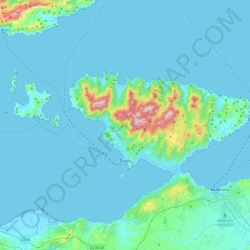
Name: Erdek topographic map, elevation, terrain.
Location: Erdek, Balıkesir, Marmara Region, 10500, Turkey (40.36778 27.56088 40.52833 28.03463)
Average elevation: 68 m
Minimum elevation: -1 m
Maximum elevation: 791 m
Other topographic maps
Click on a map to view its topography, its elevation and its terrain.
Mount Erciyes
The climate of the region is influenced by topography, with the Taurus and Kaçkar Mountains blocking the entry of moisture into Anatolia. Summers are dry and hot and winters wet and cold; in Kayseri, summer temperatures are about 19 °C (66 °F) and winter temperature about 0 °C (32 °F). Precipitation at…
Average elevation: 3,329 m
Hasan Dağı
The volcano has two summits, the 3,069 metres (10,069 ft) high eastern Small Hasan Dagi/Küçük Hasandağ and the 3,253 metres (10,673 ft) high Big Hasan Dagi/Büyük Hasandağ; both are located within a caldera and consist of lava domes and lava flows. Big Hasan Dagi has two nested craters with an 800 metres…
Average elevation: 2,707 m
Mount Suphan
Mount Süphan (Turkish: Süphan Dağı; Kurdish: Sîpanê Xelatê; Armenian: Սիփան, Sipan) is a stratovolcano located in eastern Turkey, immediately north of Lake Van. It is the second highest volcano in Turkey, with an elevation of 4,058 metres (13,314 feet), and has the third highest prominence of the…
Average elevation: 3,757 m
Pontic Mountains
Winter conditions are very harsh, and snow even in summer months isn't unusual above certain elevations.
Average elevation: 2,800 m
Keban Dam
The Keban Dam is a combined rockfill and concrete gravity hydroelectric dam operated by the State Hydraulic Works (DSİ). The dam is 1,097 metres (3,599 ft) long and its crest is 207 metres (679 ft) above the level of the river-bed (848 metres (2,782 ft) above sea-level). Its eight water turbines are capable…
Average elevation: 844 m
Konaklı
Misthi or Misti, was a Greek city in the region of Cappadocia, in what is now Turkey. It was situated 82 kilometres southwest of the regional capital of Caesarea (Greek: Καισαρεία), nowadays Kayseri, Turkey, and belonged administratively to the nearby city of Nigde, 26 kilometres north-northwest and…
Average elevation: 1,352 m
Mount Tahtali
Tahtalı Dağı lies on the east coast of the Teke Peninsula (Lycian Peninsula), dominating the landscape around Kemer. Located between Antalya and Finike and the dominant peak of the mountain range Bey Dağları (Turkish: Bey Mountains). From it, the start of the Taurus Mountains can be seen. Its close…
Average elevation: 1,790 m