
Peru topographic map
Click on the map to display elevation.
About this map
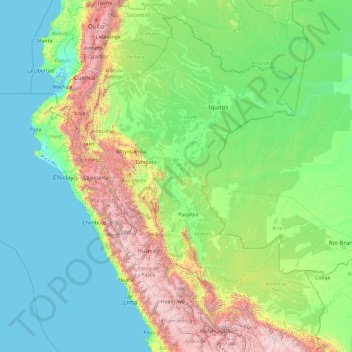
Name: Peru topographic map, elevation, terrain.
Location: Peru (-14.36997 -82.54585 0.63003 -67.54585)
Average elevation: 616 m
Minimum elevation: -3 m
Maximum elevation: 6,065 m
Other topographic maps
Click on a map to view its topography, its elevation and its terrain.
Machu Picchu
Peru > Cusco > Machupicchu > Intihuatana > San Miguel
Animals are also suspected to have migrated to Machu Picchu, as there were several bones found that were not native to the area. Most animal bones found were from llamas and alpacas. These animals naturally live at altitudes of 4,000 meters (13,000 ft) rather than the 2,400 meters (7,900 ft) elevation of Machu…
Average elevation: 2,225 m
Chachani Volcano
The volcano lies in the Andes of southern Peru, 22 kilometres (14 mi) northwest of Arequipa and north of the Arequipa Airport; the city of Arequipa is situated on the foot of Chachani and El Misti volcanoes. The road from Arequipa to Chivay runs along the southeastern foot of Chachani, and a dirt road reaches…
Average elevation: 5,562 m
Kuelap
Kuélap is located on a limestone ridge on top of a mountain at an elevation of 3000 metres, on the left bank of the Utcubamba River. It belongs to the district of Tingo, Luya Province, Amazonas. The area is covered with cloud forests, with a variety of trees, orchids and epiphytes. The protected zone covers…
Average elevation: 2,600 m
Nevado Coropuna
Coropuna is a dormant compound volcano located in the Andes mountains of southeast-central Peru. The upper reaches of Coropuna consist of several perennially snowbound conical summits, lending it the name Nevado Coropuna in Spanish. The complex extends over an area of 240 square kilometres (93 sq mi) and its…
Average elevation: 5,980 m
Laguna Aricota
Lake Aricota (possibly from Aymara ari pointed, sharp, quta lake) is a lake in Candarave Province, region of Tacna, Peru. It has an elevation of 2,800 metres (9,186 ft) above sea level.
Average elevation: 3,058 m
Yerupajá
Based on the elevation provided by the available Digital elevation models, SRTM2 (6558m with voids), SRTM filled with ASTER (6551m with voids), TanDEM-X(6110m with voids), Yerupaja is about 6635 meters above sea level. This altitude was considered due to the lack of topographic data or even handheld GPS data.
Average elevation: 5,637 m
Estrecho de Magallanes (Magallanes)
Peru > Loreto > Pebas > Estrecho de Magallanes (Magallanes)
Average elevation: 77 m