
Far-North topographic map
Interactive map
Click on the map to display elevation.
About this map
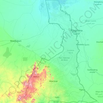
Name: Far-North topographic map, elevation, terrain.
Location: Far-North, Cameroon (9.93348 13.41220 13.08333 15.68910)
Average elevation: 357 m
Minimum elevation: 278 m
Maximum elevation: 1,312 m
These rivers all follow a tropical regime, fluctuating between high water in the wet season (May to September) and low water in the dry season (October to April). At the height of the dry season, many of the waterways disappear completely or else diminish to a mere trickle. The Logone all but disappears during the wet season. The low elevation of the Chad basin (200–500 metres) causes flooding during the wet season; the Logone is especially prone to this, and much of its basin is marshlike conditions along its length during the wet season. Even during the dry season, some of these remain, called Yaéré in Fulfulde. The El Beïd and Serbewel Rivers drain these marshy areas into Lake Chad. The Diamaré Plain, part of the Chad plain, occupies the southeastern third of the province. It is not as prone to flooding due to a number of inselbergs through the area.
Other topographic maps
Click on a map to view its topography, its elevation and its terrain.
Communauté urbaine de Bertoua
Cameroon > East > Lom-et-Djérem
Communauté urbaine de Bertoua, Lom-et-Djérem, East, Cameroon
Average elevation: 660 m
Carrefour Vogt
Cameroon > Centre > Mfoundi > Yaounde
Carrefour Vogt, Mvolye, Yaoundé III, Yaoundé, Mfoundi, Centre, Cameroon
Average elevation: 725 m
Mboméka
Cameroon > South > Dja-et-Lobo > Djoum
Mboméka, Djoum, Dja-et-Lobo, South, Cameroon
Average elevation: 639 m
Waza
Cameroon > Far-North > Logone-et-Chari
Waza, Logone-et-Chari, Far-North, Cameroon
Average elevation: 306 m
Mbankomo
Cameroon > Centre > Méfou-et-Akono
Mbankomo, Méfou-et-Akono, Centre, Cameroon
Average elevation: 723 m
Soa
Cameroon > Centre > Méfou-et-Afamba
Soa, Méfou-et-Afamba, Centre, Cameroon
Average elevation: 661 m
Douala III
Douala III, Communauté urbaine de Douala, Wouri, Littoral, Cameroon
Average elevation: 16 m
Sao
Cameroon > Far-North > Logone-et-Chari > Goulfey
Sao, Goulfey, Logone-et-Chari, Far-North, Cameroon
Average elevation: 293 m
Communauté urbaine de Ngaoundéré
Communauté urbaine de Ngaoundéré, Vina, Adamawa, Cameroon
Average elevation: 1,117 m
Pong
Cameroon > Littoral > Sanaga-Maritime > Ngambé
Pong, Ngambé, Sanaga-Maritime, Littoral, Cameroon
Average elevation: 525 m
Batchingou
Cameroon > West > Ndé > Bangangté
Batchingou, Bangangté, Ndé, West, Cameroon
Average elevation: 1,436 m
Bangang Fokam
Cameroon > West > Ndé > Bangangté
Bangang Fokam, Bangangté, Ndé, West, Cameroon
Average elevation: 1,341 m
Bandenkop
Cameroon > West > Hauts-Plateaux > Bangou
Bandenkop, Bangou, Hauts-Plateaux, West, Cameroon
Average elevation: 1,765 m
Mpagne
Cameroon > Centre > Mbam-et-Inoubou > Deuk
Mpagne, Deuk, Mbam-et-Inoubou, Centre, Cameroon
Average elevation: 669 m
Communauté urbaine d'Ebolowa
Communauté urbaine d'Ebolowa, Mvila, South, Cameroon
Average elevation: 629 m
Foreke Dschang
Cameroon > West > Menoua > Dschang
Foreke Dschang, Dschang, Menoua, West, Cameroon
Average elevation: 1,358 m
Carrefour MEEC
Cameroon > Centre > Mfoundi > Yaounde
Carrefour MEEC, Mvog-betsi, Yaoundé VI, Yaoundé, Mfoundi, Centre, Cameroon
Average elevation: 751 m
Meyos-Obam
Cameroon > South > Dja-et-Lobo > Djoum
Meyos-Obam, Djoum, Dja-et-Lobo, South, Cameroon
Average elevation: 665 m
Libolo
Cameroon > Centre > Nyong-et-Kéllé > Éséka
Libolo, Éséka, Nyong-et-Kéllé, Centre, Cameroon
Average elevation: 402 m
Balikumbat
Cameroon > Northwest > Ngoketunjia
Balikumbat, Ngoketunjia, Northwest, Cameroon
Average elevation: 1,368 m
Bamukumbit
Cameroon > Northwest > Ngoketunjia
Bamukumbit, Balikumbat, Ngoketunjia, Northwest, Cameroon
Average elevation: 1,269 m
Bafia
Cameroon > Centre > Mbam-et-Inoubou
Bafia, pk11, Mbam-et-Inoubou, Centre, Cameroon
Average elevation: 504 m
Kontcha
Cameroon > Adamawa > Faro-et-Déo
Kontcha, Faro-et-Déo, Adamawa, Cameroon
Average elevation: 435 m
Olamzé
Cameroon > South > Vallée-du-Ntem
Olamzé, Vallée-du-Ntem, South, Cameroon
Average elevation: 579 m
Éséka
Cameroon > Centre > Nyong-et-Kéllé
Éséka, Nyong-et-Kéllé, Centre, Cameroon
Average elevation: 330 m
Yagoua
Cameroon > Far-North > Mayo-Danay
Yagoua, Mayo-Danay, Far-North, Cameroon
Average elevation: 330 m