
Sumadija and Western Serbia topographic map
Interactive map
Click on the map to display elevation.
About this map
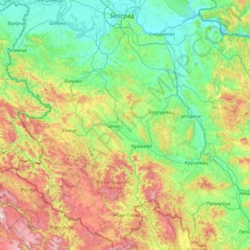
Name: Sumadija and Western Serbia topographic map, elevation, terrain.
Location: Sumadija and Western Serbia, Serbia (42.83225 19.10259 44.94169 21.82250)
Average elevation: 548 m
Minimum elevation: 65 m
Maximum elevation: 2,376 m
Other topographic maps
Click on a map to view its topography, its elevation and its terrain.
Ђаловића клисура
Serbia > Central Serbia > Zlatibor Administrative District > Sjenica Municipality > Crvsko
Average elevation: 1,091 m
Пуцкарош
Serbia > Vojvodina > South Backa Administrative District > Petrovaradin
Average elevation: 112 m
Stara planina
Serbia > Central Serbia > Pirot Administrative District > Topli Do
The park's herpetofauna includes 15 reptile and nine amphibian species. It hosts vital populations of common European adder (Vipera berus), European toad, grass snake (Natrix natrix), legless lizard, tessellated water snake, viviparous lizard and the common frog. Due to the park's high altitude, the…
Average elevation: 1,806 m
Rtanj
Serbia > Central Serbia > Zajecar Administrative District > Boljevac Municipality
Average elevation: 1,065 m
Baranda
Serbia > Vojvodina > South Banat Administrative District > Opovo Municipality
Average elevation: 75 m
Цигански логор
Serbia > Vojvodina > Srem Administrative District > Lezimir > Багрењак
Average elevation: 309 m
Zlatar
Serbia > Central Serbia > Zlatibor Administrative District > Prijepolje Municipality
Zlatar (Serbian Cyrillic: Златар, pronounced [zlǎtaːr]) is a mountain range in southwestern Serbia, lying between towns of Prijepolje and Nova Varoš. Its highest peak is Velika krseva, 1,627 meters tall, peak next to Golo brdo. It belongs to Stari Vlah group of Dinaric Alps. Zlatar is bounded by…
Average elevation: 1,438 m
Tara
Serbia > Central Serbia > Zlatibor Administrative District > Uzice
Tara (Serbian Cyrillic: Тара, pronounced [târa]) is a mountain in western Serbia. It is part of the Dinaric Alps and stands at 1,000 to 1,590 m (3,280 to 5,220 ft) above sea level. The mountain's slopes are clad in dense forests with numerous high-elevation clearings and meadows, steep cliffs, deep…
Average elevation: 1,325 m
Преслап
Serbia > Central Serbia > Nisava Administrative District > City of Niš
Average elevation: 508 m
Медведник
Serbia > Central Serbia > Kolubara Administrative District > Suvodanje
Medvednik (Serbian Cyrillic: Медведник) is a mountain in western Serbia, near the town of Valjevo. Its highest peak has an elevation of 1,247 meters above sea level.
Average elevation: 907 m
Корићани
Serbia > Central Serbia > Moravica Administrative District > Mrcajevci
Average elevation: 301 m
Думача
Serbia > Central Serbia > Macva Administrative District > Gornja Vranjska
Average elevation: 107 m
Bujanovac
Serbia > Central Serbia > Pcinja Administrative District > Bujanovac Municipality
Average elevation: 442 m
Subotica
Serbia > Vojvodina > North Backa Administrative District
It is located in the Pannonian Basin at 46.07° North, 19.68° East, at the altitude of 109m, about 10 kilometres (6 miles) from the border with Hungary, and is the northernmost city in Serbia. Lake Palić is in the immediate vicinity of the city. Sand dunes area Subotička Peščara is located north of the…
Average elevation: 115 m
Jastrebac
Serbia > Central Serbia > Rasina Administrative District > Srndalje
Jastrebac (Serbian Cyrillic: Јастребац) is a mountain in central Serbia, between cities of Niš, Kruševac and Prokuplje. It consists of two massifs, Great (Veliki) and Small (Mali) Jastrebac. Its highest peak Velika Đulica has an elevation of 1,491 meters above sea level. It is well-forested and…
Average elevation: 1,176 m
Subotica
Serbia > Vojvodina > North Backa Administrative District
It is located in the Pannonian Basin at 46.07° North, 19.68° East, at the altitude of 109m, about 10 kilometres (6 miles) from the border with Hungary, and is the northernmost city in Serbia. Lake Palić is in the immediate vicinity of the city. Sand dunes area Subotička Peščara is located north of the…
Average elevation: 115 m
Брдеж до
Serbia > Vojvodina > Srem Administrative District > Indjija Municipality > Cortanovci
Average elevation: 215 m
Kapit
Serbia > Central Serbia > Jablanica Administrative District > Medvedja Municipality
Average elevation: 530 m
Banstol
Serbia > Vojvodina > South Backa Administrative District > Sremski Karlovci Municipality
Average elevation: 222 m
Suvobor
Serbia > Central Serbia > Moravica Administrative District > Gornji Milanovac Municipality
Suvobor (Serbian Cyrillic: Сувобор) is a mountain in central Serbia, near the town of Gornji Milanovac. Its highest peak Suvobor has an elevation of 866 m (2,841 ft) above sea level.
Average elevation: 728 m
Горњи Бранетићи
Serbia > Central Serbia > Moravica Administrative District > Gornji Milanovac Municipality
Average elevation: 536 m
Gornji Milanovac
Serbia > Central Serbia > Moravica Administrative District > Gornji Milanovac Municipality
Gornji Milanovac and the villages of Varnice, Zagradje, Dragolj and Trudelj are dominated by the Ostrvica Massif. The elevation of Ostrvica is 758 metres (2,487 ft). Ostrvica is actually the remains of a destroyed volcanic cone. In May 2009, Ostrvica was declared a natural monument. In the middle of the last…
Average elevation: 412 m
Beska
Serbia > Vojvodina > Srem Administrative District > Indjija Municipality
Average elevation: 128 m
Indjija
Serbia > Vojvodina > Srem Administrative District > Indjija Municipality
Average elevation: 110 m
Maradik
Serbia > Vojvodina > Srem Administrative District > Indjija Municipality
Average elevation: 157 m
Stara Pazova
Serbia > Vojvodina > Srem Administrative District > Stara Pazova Municipality
Average elevation: 83 m
Prugovac
Serbia > Central Serbia > Nisava Administrative District > Aleksinac Municipality
Average elevation: 436 m
Begaljica
Serbia > Central Serbia > City of Belgrade > Grocka Urban Municipality
The village is located at the water source of the Begaljica river. The houses are located in the valley sides and flat areas nearer the river, while a large part is located on the hill as well. The highest elevations are at Gornji Kraj and Brđani. The atar (cadastral area) is large, while half of it is…
Average elevation: 182 m
Pranjani
Serbia > Central Serbia > Moravica Administrative District > Gornji Milanovac Municipality
Average elevation: 422 m
Despotovac
Serbia > Central Serbia > Pomoravlje Administrative District > Despotovac Municipality
Average elevation: 259 m
Bač
Serbia > Vojvodina > South Backa Administrative District > Bac Municipality
Average elevation: 83 m
Маслаћи
Serbia > Central Serbia > Zlatibor Administrative District > Pozega Municipality > Donja Dobrinja
Average elevation: 484 m
Dren
Serbia > Central Serbia > City of Belgrade > Obrenovac Urban Municipality
Average elevation: 98 m
Rudnik
Serbia > Central Serbia > Moravica Administrative District > Gornji Milanovac Municipality
Average elevation: 620 m
Deronje
Serbia > Vojvodina > West Backa Administrative District > Odzaci Municipality
Average elevation: 83 m
Prebreza
Serbia > Central Serbia > Toplica Administrative District > Blace Municipality
Average elevation: 432 m
Knjaževac
Serbia > Central Serbia > Zajecar Administrative District > Knjazevac Municipality
Average elevation: 307 m
Alibunar
Serbia > Vojvodina > South Banat Administrative District > Alibunar Municipality
Average elevation: 101 m
Краљев сто
Serbia > Central Serbia > Kolubara Administrative District > Mionica Municipality
Average elevation: 982 m
Velika Mostanica
Serbia > Central Serbia > City of Belgrade > Cukarica Urban Municipality
Average elevation: 174 m
Kopaonik
Serbia > Central Serbia > Rasina Administrative District > Brus Municipality
The national park is situated on a relatively flat region, at an altitude of about 1,700 m (5,577 ft). This central Kopaonik plateau is called Suvo Rudište. It is surrounded by mountain peaks. To the north and northwest of this plateau stretches Banjski Kopaonik, which is the location of Jošanička Banja…
Average elevation: 1,733 m
Rajac
Serbia > Central Serbia > Bor Administrative District > Negotin Municipality
Average elevation: 127 m
Ljig
Serbia > Central Serbia > Kolubara Administrative District > Ljig Municipality
Average elevation: 222 m
Mitrovac na Tari
Serbia > Central Serbia > Zlatibor Administrative District > Bajina Basta Municipality > Perucac
Average elevation: 1,135 m
Negotin
Serbia > Central Serbia > Bor Administrative District > Negotin Municipality
Average elevation: 86 m
Награмак
Serbia > Central Serbia > Zlatibor Administrative District > Bajina Basta Municipality > Beserovina
Average elevation: 1,206 m
Krusevica
Serbia > Central Serbia > Raska Administrative District > Raska Municipality
Average elevation: 809 m
Tresnja
Serbia > Central Serbia > City of Belgrade > Sopot Urban Municipality
Average elevation: 255 m
Usak
Serbia > Central Serbia > Zlatibor Administrative District > Sjenica Municipality
Average elevation: 1,095 m
Bor
Serbia > Central Serbia > Bor Administrative District
Crni Vrh is a mountain 30 km from the city center. Highest peak has an elevation of 1,043 m (3,422 ft) above sea level. It has several ski tracks anda ski lift. The main ski track is 1,100 m long and has height span of 260 m. Just 16 km from the city center there is another mountain Stol. Its highest peak has…
Average elevation: 474 m
Senta
Serbia > Vojvodina > North Banat Administrative District > Senta Municipality
Average elevation: 80 m
Backi Jarak
Serbia > Vojvodina > South Backa Administrative District > Temerin Municipality
Average elevation: 81 m
Cer
Serbia > Central Serbia > Macva Administrative District
Cer (pronounced [tsɛr]) is a mountain in western Serbia, 30 kilometers from Šabac, 100 kilometers west of Belgrade. The highest peak has an elevation of 689 m (2,260 ft) above sea level. Cer is rich in the Turkey oak forests after which it was named.
Average elevation: 480 m
Stolovi
Serbia > Central Serbia > Raska Administrative District > Kraljevo City
Stolovi (Serbian Cyrillic: Столови) is a mountain in central Serbia, near the city of Kraljevo. Its highest peak Usovica has an elevation of 1,356 meters above sea level.
Average elevation: 1,059 m
Gudurički vrh
Serbia > Vojvodina > South Banat Administrative District > City of Vršac
Average elevation: 330 m
Gučevo
Serbia > Central Serbia > Macva Administrative District > Loznica City > Banja Koviljaca
Gučevo (Serbian Cyrillic: Гучево, pronounced [ɡûːtʃeʋo]) is a mountain in western Serbia, near the town of Loznica, overlooking the Drina river and Banja Koviljača. Its highest peak Crni vrh has an elevation of 779 meters above sea level.
Average elevation: 526 m
Fruška gora
Serbia > Vojvodina > South Backa Administrative District > Beocin Municipality
Average elevation: 437 m
Vrnjacka Banja
Serbia > Central Serbia > Raska Administrative District > Vrnjacka Banja Municipality
Average elevation: 286 m
Homolje mountains
Serbia > Central Serbia > Branicevo Administrative District > Petrovac-na-Mlavi Municipality
Average elevation: 729 m
Ravna Gora
Serbia > Central Serbia > Jablanica Administrative District > Vlasotince Municipality
Average elevation: 877 m
Usce
Serbia > Central Serbia > City of Belgrade > Obrenovac Urban Municipality
Average elevation: 80 m
Mala Ivanca
Serbia > Central Serbia > City of Belgrade > Sopot Urban Municipality
Average elevation: 204 m
Pocuta
Serbia > Central Serbia > Kolubara Administrative District > Valjevo City
Average elevation: 515 m
Dobra Voda
Serbia > Central Serbia > Jablanica Administrative District > Bojnik Municipality
Average elevation: 772 m
Crna Glava
Serbia > Central Serbia > Raska Administrative District > Raska Municipality
The village is on the Kopaonik mountain range whose average elevation is 1,397 m (4,583 ft). The highest part of the village is Gobelja hill, easily identifiable from Kopaonik by its antenna. It is said that the village has the purest nature in Serbia, boasting clear waters and rare species of birds and…
Average elevation: 1,235 m
Kopaonik
Serbia > Central Serbia > Rasina Administrative District > Brus Municipality
The national park is situated on a relatively flat region, at an altitude of about 1,700 m (5,577 ft). This central Kopaonik plateau is called Suvo Rudište. It is surrounded by mountain peaks. To the north and northwest of this plateau stretches Banjski Kopaonik, which is the location of Jošanička Banja…
Average elevation: 1,733 m
Radan
Serbia > Central Serbia > Jablanica Administrative District > Bojnik Municipality
Radan (Serbian Cyrillic: Радан) is a mountain in southern Serbia, near the town of Kuršumlija. Its highest peak, Šopot, has an elevation of 1,408 meters above sea level.
Average elevation: 1,272 m
Рипањска капија
Serbia > Central Serbia > City of Belgrade > Sopot Urban Municipality
Average elevation: 245 m
Backi Petrovac
Serbia > Vojvodina > South Backa Administrative District > Backi Petrovac Municipality
Average elevation: 82 m
Prahovo
Serbia > Central Serbia > Bor Administrative District > Negotin Municipality
Average elevation: 48 m
Trstenik
Serbia > Central Serbia > Rasina Administrative District > Trstenik Municipality
Average elevation: 263 m
Apatin
Serbia > Vojvodina > West Backa Administrative District > Apatin Municipality
Average elevation: 85 m
Krnjesevci
Serbia > Vojvodina > Srem Administrative District > Stara Pazova Municipality
Average elevation: 76 m
Donja Vrbava
Serbia > Central Serbia > Moravica Administrative District > Gornji Milanovac Municipality
Average elevation: 537 m
Krupanj
Serbia > Central Serbia > Macva Administrative District > Krupanj Municipality
The town lies in western Serbia, at the southern border of the Pannonian plain and Mačva region. It is surrounded by the mountains Jagodnja, Boranja and Sokolska planina, in a valley intersected by several rivers and creeks. In the town itself, the rivers Bogoštica, Čađavica and Kržava conjoin into…
Average elevation: 484 m
Veliki Vetren
Serbia > Central Serbia > Rasina Administrative District > Varvarin Municipality
Average elevation: 527 m
Radalj
Serbia > Central Serbia > Macva Administrative District > Mali Zvornik Municipality
Average elevation: 287 m
Crni Lug
Serbia > Central Serbia > Pcinja Administrative District > City of Vranje
Average elevation: 431 m
Dobroselica
Serbia > Central Serbia > Zlatibor Administrative District > Cajetina Municipality
Average elevation: 971 m
Brezovice
Serbia > Central Serbia > Macva Administrative District > Krupanj Municipality
Average elevation: 240 m
Шетоње
Serbia > Central Serbia > Branicevo Administrative District > Petrovac-na-Mlavi Municipality
Average elevation: 192 m
Крилаш
Serbia > Central Serbia > Branicevo Administrative District > Petrovac-na-Mlavi Municipality
Average elevation: 468 m