
Make a donation
Gear up for your next adventure:
As an Amazon Associate, this site earns from qualifying purchases at no extra cost to you.
Palestinian Territories topographic map
Click on the map to display elevation.
Make a donation
Gear up for your next adventure:
As an Amazon Associate, this site earns from qualifying purchases at no extra cost to you.
About this map
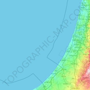
Name: Palestinian Territories topographic map, elevation, terrain.
Location: Palestinian Territories (31.22013 34.05469 32.54894 35.54036)
Average elevation: 44 m
Minimum elevation: 0 m
Maximum elevation: 896 m
Make a donation
Gear up for your next adventure:
As an Amazon Associate, this site earns from qualifying purchases at no extra cost to you.
Other topographic maps
Click on a map to view its topography, its elevation and its terrain.
Europe
Europe's topography is characterized by a striking contrast between its rugged southern mountains and the expansive plains of the north. The continent is often described as a "peninsula of peninsulas," featuring major peninsulas like the Iberian, Italian, and Balkan, each with unique geological features. In…
Average elevation: 223 m
Africa
Africa's topography is a complex tapestry of plateaus, mountains, valleys, and deserts. The continent is dominated by vast plateaus, with elevations averaging around 1,000 meters (3,281 feet), especially prominent in the south and east. The Ethiopian Highlands, often referred to as the "Roof of Africa," rise…
Average elevation: 462 m
Istanbul
Istanbul, located in northwestern Turkey, is a city that is uniquely situated across two continents, Europe and Asia, divided by the Bosphorus Strait. The city’s topography is characterized by a complex blend of hills, valleys, and coastal plains, which create a varied and scenic landscape. The European side…
Average elevation: 57 m
Make a donation
Gear up for your next adventure:
As an Amazon Associate, this site earns from qualifying purchases at no extra cost to you.
United Kingdom
Scotland accounts for just under a third (32 per cent) of the total area of the UK, covering 78,772 square kilometres (30,410 sq mi). This includes nearly eight hundred islands, predominantly west and north of the mainland; notably the Hebrides, Orkney Islands and Shetland Islands. Scotland is the most…
Average elevation: 79 m
North America
North America's topography is characterized by its diverse and dramatic landscapes, stretching from the towering Rocky Mountains in the west to the expansive Great Plains in the central region, and the rugged Appalachian Mountains in the east. The Rocky Mountains, which include peaks exceeding 20,000 feet…
Average elevation: 294 m
Edinburgh
United Kingdom > Scotland > Edinburgh
Some have called Edinburgh the Athens of the North for a variety of reasons. The earliest comparison between the two cities showed that they had a similar topography, with the Castle Rock of Edinburgh performing a similar role to the Athenian Acropolis. Both of them had flatter, fertile agricultural land…
Average elevation: 104 m
Make a donation
Gear up for your next adventure:
As an Amazon Associate, this site earns from qualifying purchases at no extra cost to you.
Appalachian Mountains
United States > North Carolina > Yancey County
The Appalachian Mountains (French: Appalaches), often called the Appalachians, are a system of mountains in eastern to northeastern North America. The Appalachians first formed roughly 480 million years ago during the Ordovician Period. They once reached elevations similar to those of the Alps and the Rocky…
Average elevation: 1,463 m
Asia
Average elevation: 563 m
Riyadh
Riyadh has a hot desert climate (Köppen Climate Classification BWh), with long, extremely hot summers and short, very mild winters. The average high temperature in August is 43.6 °C (110.5 °F). If it was not for the elevation the city was on, Riyadh would experience an even hotter climate. The city…
Average elevation: 630 m
Make a donation
Gear up for your next adventure:
As an Amazon Associate, this site earns from qualifying purchases at no extra cost to you.
South America
The east-central Brazilian plateau has a humid and warm tropical climate. The northern and eastern parts of the Argentine pampas have a humid subtropical climate with dry winters and humid summers of the Chinese type, while the western and eastern ranges have a subtropical climate of the dinaric type. At the…
Average elevation: 283 m
Cambridge
United Kingdom > England > Cambridge
The city, like most of the UK, has a maritime climate highly influenced by the Gulf Stream. Located in the driest region of Britain, Cambridge's rainfall averages around 570 mm (22.44 in) per year, around half the national average, with some years occasionally falling into the semi-arid (under 500 mm (19.69…
Average elevation: 18 m
Make a donation
Gear up for your next adventure:
As an Amazon Associate, this site earns from qualifying purchases at no extra cost to you.
Johannesburg
South Africa > Gauteng > City of Johannesburg Metropolitan Municipality
Johannesburg is located in the eastern plateau area of South Africa known as the Highveld, at an elevation of 1,753 metres (5,751 ft). The former Central Business District is located on the southern side of the prominent ridge called the Witwatersrand (English: White Water's Ridge) and the terrain falls to the…
Average elevation: 1,615 m
Mexico City
Mexico is crossed from north to south by two mountain ranges known as Sierra Madre Oriental and Sierra Madre Occidental, which are the extension of the Rocky Mountains from northern North America. From east to west at the center, the country is crossed by the Trans-Mexican Volcanic Belt also known as the…
Average elevation: 2,321 m
Bogota
The city is located in the center of Colombia, on a high plateau known as the Bogotá savanna, part of the Altiplano Cundiboyacense located in the Eastern Cordillera of the Andes. Its altitude averages 2,640 meters (8,660 ft) above sea level. Subdivided into 20 localities, Bogotá has an area of 1,587 square…
Average elevation: 2,735 m
Make a donation
Gear up for your next adventure:
As an Amazon Associate, this site earns from qualifying purchases at no extra cost to you.
Virginia Beach
United States > Virginia > Virginia Beach
According to the United States Census Bureau, the city has a total area of 497 square miles (1,290 km2), of which 249 square miles (640 km2) is land and 248 square miles (640 km2) (49.9%) is water. It is the largest city in Virginia by total area and third-largest city land area. The average elevation is 12…
Average elevation: 2 m
Baltimore
United States > Maryland > Baltimore
Baltimore is in north-central Maryland on the Patapsco River close to where it empties into the Chesapeake Bay. The city is also located on the fall line between the Piedmont Plateau and the Atlantic coastal plain, which divides Baltimore into "lower city" and "upper city". The city's elevation ranges from sea…
Average elevation: 65 m
Hull
United Kingdom > England > Kingston upon Hull
Kingston upon Hull is on the northern bank of the Humber Estuary. The city centre is west of the River Hull and close to the Humber. The city is built upon alluvial and glacial deposits which overlie chalk rocks but the underlying chalk has no influence on the topography. The land within the city is generally…
Average elevation: 21 m
Make a donation
Gear up for your next adventure:
As an Amazon Associate, this site earns from qualifying purchases at no extra cost to you.
Berlin
Berlin straddles the banks of the River Spree, which flows into the River Havel (a tributary of the River Elbe) in the western borough of Spandau. Among the city's main topographical features are the many lakes in the western and southeastern boroughs formed by the Spree, Havel, and Dahme rivers (the largest…
Average elevation: 47 m
Columbus
United States > Ohio > Franklin County > Columbus
The confluence of the Scioto and Olentangy rivers is just north-west of Downtown Columbus. Several smaller tributaries course through the Columbus metropolitan area, including Alum Creek, Big Walnut Creek, and Darby Creek. Columbus is considered to have relatively flat topography thanks to a large glacier that…
Average elevation: 255 m
Cape Town
South Africa > Western Cape > City of Cape Town
The Cape Peninsula is 52 km long from Mouille Point in the north to Cape Point in the south, with an area of about 470 km2, and it displays more topographical variety than other similar sized areas in southern Africa, and consequently spectacular scenery. There are diverse low-nutrient soils, large rocky…
Average elevation: 53 m
Western Ghats
The range starts near south of the Tapti river and runs approximately 1,600 km (990 mi) through the states of Gujarat, Maharashtra, Karnataka, Goa, Kerala and Tamil Nadu ending at Marunthuvazh Malai, Swamithope near the southern tip of India. These hills cover 160,000 km2 (62,000 sq mi) and form the catchment…
Average elevation: 2,225 m
Make a donation
Gear up for your next adventure:
As an Amazon Associate, this site earns from qualifying purchases at no extra cost to you.
Almaty
Almaty continues as the major commercial and cultural centre of Kazakhstan, as well as its most populous and most cosmopolitan city. The city is located in the mountainous area of southern Kazakhstan near the border with Kyrgyzstan in the foothills of the Trans-Ili Alatau at an elevation of 700–900 m…
Average elevation: 1,261 m
Make a donation
Gear up for your next adventure:
As an Amazon Associate, this site earns from qualifying purchases at no extra cost to you.
Glasgow
United Kingdom > Scotland > Glasgow City
Glasgow itself was reputed to have been founded by the Christian missionary Saint Mungo in the 6th century. He established a church on the Molendinar Burn, where the present Glasgow Cathedral stands, and in the following years Glasgow became a religious centre. Glasgow grew over the following centuries. The…
Average elevation: 128 m
Portsmouth
United Kingdom > England > Hampshire > Portsmouth
By road, Portsmouth lies 73.5 miles (118.3 km) from Central London, 49.5 miles (79.7 km) west of Brighton, and 22.3 miles (35.9 km) east of Southampton. Portsmouth is situated primarily on Portsea Island and is the United Kingdom's only island city, although parts of it have expanded onto the mainland. Gosport…
Average elevation: 28 m
Kolkata
Spread roughly north–south along the east bank of the Hooghly River, Kolkata sits within the lower Ganges Delta of eastern India approximately 75 km (47 mi) west of the international border with Bangladesh; the city's elevation is 1.5–9 m (5–30 ft). Much of the city was originally a wetland that was…
Average elevation: 5 m
São Paulo
Brazil > São Paulo > Região Metropolitana de São Paulo > São Paulo
São Paulo is in Southeastern Brazil, in southeastern São Paulo State, approximately halfway between Curitiba and Rio de Janeiro. The city is on a plateau placed beyond the Serra do Mar (Portuguese for "Sea Range" or "Coastal Range"), itself a component of the vast region known as the Brazilian Highlands,…
Average elevation: 785 m
Make a donation
Gear up for your next adventure:
As an Amazon Associate, this site earns from qualifying purchases at no extra cost to you.
Mediterranean Sea
Average elevation: 0 m
Central Park
United States > New York > New York County > New York
In June 1856, Fernando Wood appointed a "consulting board" of seven people, headed by author Washington Irving, to inspire public confidence in the proposed development. Wood hired military engineer Egbert Ludovicus Viele as the park's chief engineer, tasking him with a topographical survey of the site. The…
Average elevation: 26 m
Athens
Greece > Attica > Regional Unit of Central Athens
Owing to the rain shadow of the Pindus Mountains, annual precipitation of Athens is lower than most other parts of Greece, especially western Greece. As an example, Ioannina receives around 1,300 mm (51 in) per year, and Agrinio around 800 mm (31 in) per year. Daily average highs for July have been measured…
Average elevation: 168 m
Make a donation
Gear up for your next adventure:
As an Amazon Associate, this site earns from qualifying purchases at no extra cost to you.
Leeds
Lying in the eastern foothills of the Pennines, there is a significant variation in elevation within the city's built-up area. The district ranges from 1,115 feet (340 m) in the far west on the slopes of Ilkley Moor to about 33 feet (10 m) where the rivers Aire and Wharfe cross the eastern boundary. Land rises…
Average elevation: 94 m
Make a donation
Gear up for your next adventure:
As an Amazon Associate, this site earns from qualifying purchases at no extra cost to you.
Ural Mountains
Russia > Khanty-Mansiysk Autonomous Okrug – Ugra > Beryozovsky District
The Ural Mountains (/ˈjʊərəl/ YOOR-əl; Russian: Ура́льские го́ры, tr. Uralskiye gory, IPA: [ʊˈralʲskʲɪjə ˈɡorɨ]; Bashkir: Урал тауҙары) or simply the Urals, are a mountain range in Eurasia that runs north-south mostly through Russia, from the coast of the Arctic Ocean to…
Average elevation: 1,435 m
Hamburg
The neighborhoods of Neuenfelde, Cranz, Francop and Finkenwerder are part of the Altes Land (old land) region, the largest contiguous fruit-producing region in Central Europe. Neugraben-Fischbek has Hamburg's highest elevation, the Hasselbrack at 116.2 metres (381 ft) AMSL. Hamburg borders the states of…
Average elevation: 23 m
Make a donation
Gear up for your next adventure:
As an Amazon Associate, this site earns from qualifying purchases at no extra cost to you.
Chongqing
The central urban area of Chongqing, or Chongqing proper, is a city of unique features. Built on mountains and partially surrounded by the Yangtze and Jialing rivers, it is known as a "mountain city" and a "city on rivers". The night scene of the city is very illuminated, with millions of lights and their…
Average elevation: 318 m
Dundee
United Kingdom > Scotland > Dundee City
Dundee sits on the north bank of the Firth of Tay on the eastern, North Sea Coast of Scotland. The city lies 36.1 miles (58 km) NNE of Edinburgh and 360.6 miles (580 km) NNW of London. The built-up area occupies a roughly rectangular shape 8.3 miles (13 km) long by 2.5 miles (4 km) wide, aligned in an east to…
Average elevation: 82 m
Make a donation
Gear up for your next adventure:
As an Amazon Associate, this site earns from qualifying purchases at no extra cost to you.
Pittsburgh
United States of America > Pennsylvania > Pittsburgh
The warmest month of the year in Pittsburgh is July, with a 24-hour average of 72.6 °F (22.6 °C). Conditions are often humid, and combined with highs reaching 90 °F (32 °C) on an average 9.5 days a year, a considerable heat index arises. The coolest month is January, when the 24-hour average is 28.4 °F…
Average elevation: 315 m
Dubai
Dubai lies directly within the Arabian Desert. However, the topography of Dubai is significantly different from that of the southern portion of the UAE in that much of Dubai's landscape is highlighted by sandy desert patterns, while gravel deserts dominate much of the southern region of the country. The sand…
Average elevation: 7 m
Mount Hood
United States > Oregon > Hood River County
Timberline Lodge is a National Historic Landmark located on the southern flank of Mount Hood just below Palmer Glacier, with an elevation of about 6,000 ft (1,800 m).
Average elevation: 2,716 m
Make a donation
Gear up for your next adventure:
As an Amazon Associate, this site earns from qualifying purchases at no extra cost to you.
Make a donation
Gear up for your next adventure:
As an Amazon Associate, this site earns from qualifying purchases at no extra cost to you.
Medellín
Colombia > Antioquia > Medellín
Medellín has 16 comunas (districts), 5 corregimientos (townships), and 271 barrios (neighborhoods). The metropolitan area of Medellín lies within the Aburrá valley at an elevation of 1,500 metres (4,900 feet) above sea level and is bisected by the Medellín River (also called Porce), which flows northward.…
Average elevation: 2,098 m
Cluj-Napoca
A wide variety of flora grow in the Cluj-Napoca Botanical Garden; some animals have also found refuge there. The city has a number of other parks, of which the largest is the Central Park. This park was founded during the 19th century and includes an artificial lake with an island, as well as the largest…
Average elevation: 490 m
Make a donation
Gear up for your next adventure:
As an Amazon Associate, this site earns from qualifying purchases at no extra cost to you.
Scottsdale
United States > Arizona > Maricopa County > Scottsdale
The city is in the Salt River Valley, or the "Valley of the Sun," in the northern reaches of the Sonoran Desert. Scottsdale, 31 mi (50 km) long and 11.4 mi (18.3 km) wide at its widest point, shares boundaries with many other municipalities and entities. On the west, Scottsdale is bordered by Phoenix, Paradise…
Average elevation: 414 m
Make a donation
Gear up for your next adventure:
As an Amazon Associate, this site earns from qualifying purchases at no extra cost to you.
Haifa
Haifa is the center of liberal Arabic-speaking culture, as it was under British colonial rule. The Arabic-speaking neighborhoods, which are mixed Muslim and Christian, are in the lowlands near the sea, while Jewish neighborhoods are at higher elevation. An active Arab cultural life has developed in the 21st…
Average elevation: 100 m
Indianapolis
United States > Indiana > Indianapolis
Indianapolis is within the Tipton Till Plain, a flat to gently sloping terrain underlain by glacial deposits known as till. The lowest point in the city is about 650 feet (198 m) above mean sea level, with the highest natural elevation at about 900 feet (274 m) above sea level. Few hills or short ridges, known…
Average elevation: 241 m
Make a donation
Gear up for your next adventure:
As an Amazon Associate, this site earns from qualifying purchases at no extra cost to you.
Mount Everest
Nepal > Eastern Development Region > Qutang > Khumjung
Mount Everest (Chinese: 珠穆朗玛 Zhūmùlǎngmǎ; Nepali: सगरमाथा, romanized: Sagarmāthā; Tibetan: Chomolungma ཇོ་མོ་གླང་མ) is Earth's highest mountain above sea level, located in the Mahalangur Himal sub-range of the Himalayas. The China–Nepal border runs across its…
Average elevation: 7,841 m
Make a donation
Gear up for your next adventure:
As an Amazon Associate, this site earns from qualifying purchases at no extra cost to you.
Make a donation
Gear up for your next adventure:
As an Amazon Associate, this site earns from qualifying purchases at no extra cost to you.
Salisbury
United Kingdom > England > Salisbury
Bishop of Salisbury Hubert Walter was instrumental in the negotiations with Saladin during the Third Crusade, but he spent little time in his diocese prior to his elevation to archbishop of Canterbury. The brothers Herbert and Richard Poore succeeded him and began planning the relocation of the cathedral into…
Average elevation: 96 m
Swindon
United Kingdom > England > Swindon
Swindon has an oceanic climate (Cfb in the Köppen climate classification), like the vast majority of the British Isles, with cool winters and warm summers. The nearest official weather station is RAF Lyneham, about 10 miles (16 km) west southwest of Swindon town centre. The weather station's elevation is 145…
Average elevation: 108 m
Kilimanjaro
Mount Kilimanjaro (/ˌkɪlɪmənˈdʒɑːroʊ/) is a dormant volcano in Tanzania. It is the highest mountain in Africa and the highest free-standing mountain above sea level in the world: 5,895 m (19,341 ft) above sea level and 4,900 m (16,100 ft) above its plateau base. It is also the highest volcano in the…
Average elevation: 1,537 m
Make a donation
Gear up for your next adventure:
As an Amazon Associate, this site earns from qualifying purchases at no extra cost to you.
Snowdon
United Kingdom > Wales > Gwynedd
Snowdon (/ˈsnoʊdən/) or Yr Wyddfa (pronounced [ər ˈʊɨ̞̯ðva] (listen)), is the highest mountain in Wales, at an elevation of 1,085 metres (3,560 ft) above sea level, and the highest point in the British Isles outside the Scottish Highlands. It is located in Snowdonia National Park (Parc Cenedlaethol…
Average elevation: 692 m
Abha
Abha is located in the southern region of Asir at an elevation of about 2,270 metres (7,450 feet) above sea level. Abha lies on the western edge of Mount Al-Hijaz, near Jabal Sawda, the highest peak in Saudi Arabia. Treating the Asir Mountains as part of the Sarawat, the landscape is otherwise dominated by the…
Average elevation: 1,994 m
Make a donation
Gear up for your next adventure:
As an Amazon Associate, this site earns from qualifying purchases at no extra cost to you.
Gaziantep
The plan introduced several important changes to the city's transportation network. One of the most important was the addition of a rail line to connect Gaziantep to the national rail system. Up to now, Turkish railway construction had ignored Gaziantep (partly because of its mountainous surroundings); a…
Average elevation: 880 m
Make a donation
Gear up for your next adventure:
As an Amazon Associate, this site earns from qualifying purchases at no extra cost to you.
Quito
Quito (Spanish pronunciation: [ˈkito] (listen); Quechua: Kitu), formally San Francisco de Quito, is the capital and most populous city of Ecuador, with an estimated population of 2.8 million in its urban area. It is also the capital of the province of Pichincha. Quito is located in a valley on the eastern…
Average elevation: 2,930 m
Riverside
United States of America > California > Riverside
Riverside is the 59th largest city in the United States, the 12th largest city in California, and the largest city in California's Inland Empire metro area. According to the United States Census Bureau, the city has a total area of 81.4 square miles (210.8 km2), of which 81.1 square miles (210 km2) is land and…
Average elevation: 351 m
Karachi
Pakistan > Sindh > Karachi South District > Saddar Town
Karachi lies very close to a major fault line, where the Indian tectonic plate meets the Arabian tectonic plate. Within the city of Karachi are two small ranges: the Khasa Hills and Mulri Hills, which lie in the northwest and act as a barrier between North Nazimabad and Orangi. Karachi's hills are barren and…
Average elevation: 20 m
Make a donation
Gear up for your next adventure:
As an Amazon Associate, this site earns from qualifying purchases at no extra cost to you.
Aberdeen
United Kingdom > Scotland > Aberdeen
Two weather stations collect climate data for the area, Aberdeen/Dyce Airport, and Craibstone. Both are about 4 1⁄2 miles (7 km) to the north west of the city centre, and given that they are in close proximity to each other, exhibit very similar climatic regimes. Dyce tends to have marginally warmer daytime…
Average elevation: 52 m
Battle of Waterloo
Belgium > Walloon Brabant > Waterloo
Waterloo was the decisive engagement of the Waterloo Campaign and Napoleon's last. According to Wellington, the battle was "the nearest-run thing you ever saw in your life". Napoleon abdicated four days later, and coalition forces entered Paris on 7 July. The defeat at Waterloo ended Napoleon's rule as Emperor…
Average elevation: 121 m
Make a donation
Gear up for your next adventure:
As an Amazon Associate, this site earns from qualifying purchases at no extra cost to you.